
Canton of Châtel-sur-Moselle
| Former canton of Châtel-sur-Moselle |
|
|---|---|
| region | Lorraine |
| Department | Vosges |
| Arrondissement | Epinal |
| main place | Châtel-sur-Moselle |
| Dissolution date | March 29, 2015 |
| Residents | 19,871 (Jan 1, 2012) |
| Population density | 80 inhabitants / km² |
| surface | 247.94 km² |
| Communities | 23 |
| INSEE code | 8806 |
The Canton of Châtel-sur-Moselle was 2015 a French constituency in the district Epinal , in the Vosges department and in the region of Lorraine ; its main town was Châtel-sur-Moselle . The last representative in the General Council of the Département was Colette Marchal from 2008 to 2015 (initially DVD , now NC ).
location
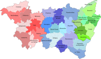
The canton was in the north of the Vosges department.

Location of the canton of Châtel-sur-Moselle within the arrondissement of Épinal
Location of the canton of Châtel-sur-Moselle within the Vosges department


Communities
The canton consisted of 23 municipalities:
| local community | Population year | Area km² | Population density | Code INSEE | Post Code |
|---|---|---|---|---|---|
| Badménil-aux-Bois | 146 (2013) | 9.14 | 16 inhabitants / km² | 88027 | 88330 |
| Bayecourt | 271 (2013) | 6.92 | 39 inhabitants / km² | 88040 | 88150 |
| Châtel-sur-Moselle | 1,680 (2013) | 11.86 | 142 inhabitants / km² | 88094 | 88330 |
| Chavelot | 1,472 (2013) | 6.16 | 239 inhabitants / km² | 88099 | 88150 |
| Damas-aux-Bois | 266 (2013) | 29.46 | 9 inhabitants / km² | 88121 | 88330 |
| Domèvre-sur-Durbion | 290 (2013) | 12.51 | 23 inhabitants / km² | 88143 | 88330 |
| Frizon | 496 (2013) | 11.75 | 42 inhabitants / km² | 88190 | 88440 |
| Gigney | 55 (2013) | 5.09 | 11 inhabitants / km² | 88200 | 88390 |
| Girmont | 993 (2013) | 12.73 | 78 inhabitants / km² | 88204 | 88150 |
| Hadigny-les-Verrières | 382 (2013) | 13.74 | 28 inhabitants / km² | 88224 | 88330 |
| Haillainville | 173 (2013) | 12.26 | 14 inhabitants / km² | 88228 | 88330 |
| Igney | 1,181 (2013) | 7.66 | 154 inhabitants / km² | 88247 | 88150 |
| Mazeley | 271 (2013) | 10.39 | 26 inhabitants / km² | 88294 | 88150 |
| Moriville | 429 (2013) | 25.05 | 17 inhabitants / km² | 88313 | 88330 |
| Nomexy | 2,192 (2013) | 7.95 | 276 inhabitants / km² | 88327 | 88440 |
| Oncourt | 185 (2013) | 3.94 | 47 inhabitants / km² | 88337 | 88150 |
| Pallegney | 176 (2013) | 5.93 | 30 inhabitants / km² | 88342 | 88330 |
| Rehaincourt | 331 (2013) | 15.22 | 22 inhabitants / km² | 88379 | 88330 |
| Sercoeur | 256 (2013) | 9.18 | 28 inhabitants / km² | 88454 | 88600 |
| Thaon-les-Vosges | 7,895 (2013) | 11.7 | 675 inhabitants / km² | 88465 | 88150 |
| Vaxoncourt | 527 (2013) | 8.43 | 63 inhabitants / km² | 88497 | 88330 |
| Villoncourt | 114 (2013) | 6.4 | 18 inhabitants / km² | 88509 | 88150 |
| Zincourt | 90 (2013) | 4.47 | 20 inhabitants / km² | 88532 | 88330 |
Population development
| 1962 | 1968 | 1975 | 1982 | 1990 | 1999 | 2006 | 2012 |
|---|---|---|---|---|---|---|---|
| 20,000 | 18,925 | 18,920 | 19,440 | 19,351 | 19,212 | 19,568 | 19,871 |