
Canton of Saulxures-sur-Moselotte
| Former canton of Saulxures-sur-Moselotte |
|
|---|---|
| region | Lorraine |
| Department | Vosges |
| Arrondissement | Epinal |
| main place | Saulxures-sur-Moselotte |
| Dissolution date | March 29, 2015 |
| Residents | 18,670 (Jan. 1, 2012) |
| Population density | 75 inhabitants / km² |
| surface | 249.34 km² |
| Communities | 10 |
| INSEE code | 8825 |
The canton of Saulxures-sur-Moselotte was a French canton in the Arrondissement Épinal , in the Département Vosges and in the Lorraine region until 2015 ; its main town was Saulxures-sur-Moselotte . The last representative in the General Council of the Département was (last re-elected in 2011) Guy Vaxelaire ( PS ).
history
The nationwide changes in the composition of the cantons resulted in the dissolution of the canton Saulxures-sur-Moselotte on January 1, 2015. The ten municipalities of the canton merged with five municipalities from the canton of Remiremont in the new canton of La Bresse .
location
The canton was on the eastern border of the Vosges department.
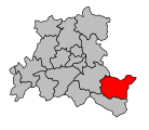
Location of the canton of Saulxures-sur-Moselotte within the arrondissement of Épinal
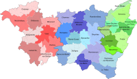
Location of the canton of Saulxures-sur-Moselotte within the Vosges department


Communities
The canton consisted of ten municipalities:
| local community | Population year | Area km² | Population density | Code INSEE | Post Code |
|---|---|---|---|---|---|
| Basse-sur-le-Rupt | 876 (2013) | 13.73 | 64 inhabitants / km² | 88037 | 88120 |
| La Bresse | 4,262 (2013) | 57.94 | 74 inhabitants / km² | 88075 | 88250 |
| Cornimont | 3,402 (2013) | 40.23 | 85 inhabitants / km² | 88116 | 88310 |
| Gerbamont | 371 (2013) | 9.69 | 38 inhabitants / km² | 88197 | 88120 |
| Rochesson | 708 (2013) | 21.49 | 33 inhabitants / km² | 88391 | 88120 |
| Sapois | 647 (2013) | 16.89 | 38 inhabitants / km² | 88442 | 88120 |
| Saulxures-sur-Moselotte | 2,721 (2013) | 31.87 | 85 inhabitants / km² | 88447 | 88290 |
| Thiéfosse | 609 (2013) | 7.62 | 80 inhabitants / km² | 88467 | 88290 |
| Vagney | 3,961 (2013) | 24.91 | 159 inhabitants / km² | 88486 | 88120 |
| Ventron | 883 (2013) | 24.97 | 35 inhabitants / km² | 88500 | 88310 |
Population development
| 1962 | 1968 | 1975 | 1982 | 1990 | 1999 | 2006 | 2012 |
|---|---|---|---|---|---|---|---|
| 20,868 | 20,939 | 21,471 | 20,862 | 20,151 | 19,644 | 19,318 | 18,670 |
swell
Coordinates: 47 ° 57 ' N , 4 ° 46' E