Avière
| Avière | ||
|
The river at Oncourt |
||
| Data | ||
| Water code | FR : A46-0200 | |
| location |
France
|
|
| River system | Rhine | |
| Drain over | Moselle → Rhine → North Sea | |
| source | in the parish of Renauvoid, 48 ° 8 ′ 1 ″ N , 6 ° 22 ′ 42 ″ E |
|
| Source height | approx. 410 m | |
| muzzle | in the municipality of Châtel-sur-Moselle Coordinates: 48 ° 19 ′ 22 ″ N , 6 ° 22 ′ 10 ″ E 48 ° 19 ′ 22 ″ N , 6 ° 22 ′ 10 ″ E |
|
| Mouth height | approx. 284 m | |
| Height difference | approx. 126 m | |
| Bottom slope | approx. 4.5 ‰ | |
| length | 28 km | |
| Catchment area | 108.2 km² | |
| Drain at the mouth |
MQ |
1.28 m³ / s |
| Reservoirs flowed through | Reservoir de Bouzey | |
|
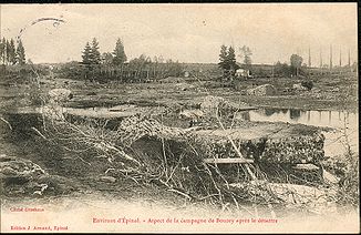
After the flood disaster in 1895 |
||
The Avière is a river in France that runs in the Vosges department in the Grand Est region .
geography
course
The Avière rises in the Forêt d'Avière , in the municipality of Renauvoid and generally drains in a northerly direction. The Avière is in Réservoir de Bouzey dammed and the water supply of the navigation channel of the Vosges Canal used. It crosses under the canal near Sanchey and a second time just before its confluence as a left tributary into the Moselle, which it reaches after 28 kilometers in the municipality of Châtel-sur-Moselle .
The Syndicat Mixte pour l'Aménagement du Bassin de l'Avière ( SMABA ) is responsible for the preservation and ecological rehabilitation of the Avière and its tributaries .
Catchment area
The catchment area of the Avière is 108.2 km² and consists of 52.17% agricultural area, 39.35% forest areas, 1.15% water surfaces and 7.57% built-up areas.
Area distribution

Tributaries
- Ruisseau de l'Etang Coster ( left ), 1.2 miles
- Ruisseau de l'Etang du Houe ( left ), 0.7 km
- Ruisseau de l'Etang de la Comtesse ( right ), 1.2 km
- Rigole d'alimentation du Reservoir de Bouzey (right), 41.5 km
- Canal de l'Est (South branch)
- Ruisseau du Breuil ( left ), 3.8 km
- Ruisseau de Devant la Souche ( left ), 2.5 km
- Ruisseau des Rayeux ( left ), 5.2 km
- Ruisseau des Roseaux ( left ), 3.5 km
- Ruisseau l'Epine ( right ), 2.7 km
- Ruisseau de Corbe ( left ), 4.2 km
- Ruisseau de Flauzey (Ruisseau de Mazeley) ( left ), 6.3 km
- Ruisseau le Poinsot ( left ), 4.4 km
Places on the river
Hydrology
At the confluence with the Moselle, the mean flow rate (MQ) is 1.28 m³ / s; the catchment area here covers 108.2 km².
In Frizon, the average annual runoff of the Avière was calculated over a period of 41 years (1970–2010) . The catchment area at this point corresponds to about 106 km², about 98% of the entire catchment area of the river.
The flow rate of the Avière in Frizon, with an annual average of 1.24 m³ / s, fluctuates relatively strongly in the course of the year. The highest water levels are measured between December and March. The flow rate reached its peak in February at 2.05 m³ / s. From April onwards, the discharge drops noticeably month after month and reaches its lowest level in August with 0.49 m³ / s, only to increase steadily from month to month in October.
Data calculated from the values for the years 1970 - 2010

history
The dam of the Réservoir de Bouzey was put into operation in 1880. It was founded on sandstone, but not deep enough to a stable rock. Back then, people did not have the necessary knowledge about the statics of dams. The wall was miscalculated by today's standards and was therefore much too slim. As early as 1884 there was damage from seepage water. This one tried unsuccessfully to seal.
In April 1895 the reservoir was completely dammed during a flood. Due to the load, the wall fell over in one piece over a length of 171 m and at a height of 12 m. About 100 to 200 people died and the damage to property was considerable. The surrounding villages on the upper reaches of the Avière were most severely damaged, and the industrial community of Nomexy, where the tidal wave hit the Moselle valley, was also affected.
Web links
- Débits caractéristiques de l'Avière (French; PDF; 14 kB)
- Course of the Avière at SANDRE
Individual evidence
- ↑ a b geoportail.fr (1: 16,000)
- ↑ a b c The information is based on information about the Avière at SANDRE (French).
- ↑ a b c see web link: Débits caractéristiques de l'Avière
- ↑ cc-olima-aviere.fr/environnement ( page no longer available , search in web archives ) Info: The link was automatically marked as defective. Please check the link according to the instructions and then remove this notice. (French)
- ↑ a b c Self-measurement on Géoportail
- ↑ lower course
- ↑ Banque Hydro - Station A4632010 L'Avière à Frizon [Basse Frizon (menu item: Synthèse)]

