Saint-Supplet
| Saint-Supplet | ||
|---|---|---|

|
|
|
| region | Grand Est | |
| Department | Meurthe-et-Moselle | |
| Arrondissement | Briey | |
| Canton | Mont-Saint-Martin | |
| Community association | Terre Lorraine du Longuyonnais | |
| Coordinates | 49 ° 23 ' N , 5 ° 44' E | |
| height | 243-323 m | |
| surface | 7.43 km 2 | |
| Residents | 139 (January 1, 2017) | |
| Population density | 19 inhabitants / km 2 | |
| Post Code | 54620 | |
| INSEE code | 54489 | |
| Website | http://www.saint-supplet.fr/ | |
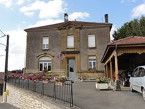
 Town Hall (Mairie) in Saint-Supplet |
||
Saint-Supplet is a French commune with 139 inhabitants (as of January 1, 2017) in the Meurthe-et-Moselle department in the Grand Est region (until 2015 Lorraine ). The municipality belongs to the arrondissement of Briey and the canton of Mont-Saint-Martin (until 2015: canton of Audun-le-Roman ).
geography
Saint-Supplet is about 50 kilometers southwest of Luxembourg . Saint-Supplet is surrounded by the neighboring communities of Han-devant-Pierrepont in the north, Mercy-le-Bas in the east, Xivry-Circourt in the south and south-east, Spincourt in the south and south-west and Saint-Pierrevillers in the west.
Population development
| year | 1962 | 1968 | 1975 | 1982 | 1990 | 1999 | 2006 | 2013 |
|---|---|---|---|---|---|---|---|---|
| Residents | 296 | 230 | 207 | 200 | 186 | 165 | 173 | 161 |
| Source: Cassini and INSEE | ||||||||
Attractions
- Saint-Sulpice church from the 14th / 15th centuries century
- General Guinot's burial chapel
Web links
Commons : Saint-Supplet - collection of images, videos and audio files

