
Mairy-Mainville
| Mairy-Mainville | ||
|---|---|---|

|
|
|
| region | Grand Est | |
| Department | Meurthe-et-Moselle | |
| Arrondissement | Briey | |
| Canton | Pays de Briey | |
| Community association | Pays de l'Audunois et du Bassin de Landres | |
| Coordinates | 49 ° 18 ′ N , 5 ° 50 ′ E | |
| height | 237-325 m | |
| surface | 12.42 km 2 | |
| Residents | 566 (January 1, 2017) | |
| Population density | 46 inhabitants / km 2 | |
| Post Code | 54150 | |
| INSEE code | 54334 | |

Mairy-Mainville is a French commune with 948 inhabitants (as of January 1, 2017) in the Meurthe-et-Moselle department in the Grand Est region (before 2016: Lorraine ). The municipality belongs to the Arrondissement of Briey and the canton of Pays de Briey (until 2015: canton of Audun-le-Roman ).
geography
Mairy-Mainville is located about 39 kilometers south-southwest of Luxembourg and 23 kilometers west-southwest of Thionville on the Woigot River . Mairy-Mainville is surrounded by the neighboring communities of Mont-Bonvillers in the north, Anderny in the north and northeast, Tucquegnieux in the east, Anoux in the south and Landres in the west.
Population development
| year | 1962 | 1968 | 1975 | 1982 | 1990 | 1999 | 2006 | 2013 |
|---|---|---|---|---|---|---|---|---|
| Residents | 615 | 572 | 531 | 456 | 468 | 479 | 536 | 557 |
| Source: Cassini and INSEE | ||||||||
Attractions
- Church of Saint Martin in Mairy from the 12th century, Monument historique
- Saint-Pierre church in Mainville from the 13th century
- Saint-Rémi church
- Sainte-Barbe Chapel in Mainville from the 18th century
- Mairy Castle, built between 1594 and 1602
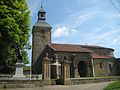
Saint Martin Church

Saint-Rémi church

Saint-Pierre church

Chapel of Sainte-Barbe

.JPG)


Web links
Commons : Mairy-Mainville - Collection of images, videos and audio files