
Gorcy
| Gorcy | ||
|---|---|---|

|
|
|
| region | Grand Est | |
| Department | Meurthe-et-Moselle | |
| Arrondissement | Briey | |
| Canton | Mont-Saint-Martin | |
| Community association | Longwy | |
| Coordinates | 49 ° 32 ' N , 5 ° 41' E | |
| height | 235-385 m | |
| surface | 4.1 km 2 | |
| Residents | 2,763 (January 1, 2017) | |
| Population density | 674 inhabitants / km 2 | |
| Post Code | 54730 | |
| INSEE code | 54234 | |
| Website | http://mairie.pagespro-orange.fr/mairie.gorcy | |
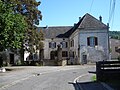
 Gorcy Town Hall |
||

Gorcy is a French commune with 2,763 inhabitants (as of January 1, 2017) in the Meurthe-et-Moselle department in the Grand Est region (until 2015 Lorraine ). It belongs to the Arrondissement of Briey and the canton of Mont-Saint-Martin . The inhabitants are called Gorcéens .
geography
Gorcy is on the Belgian border. Gorcy is surrounded by the neighboring communities of Musson in the north, Cosnes-et-Romain in the south and east and Ville-Houdlémont in the west.
history
The place was first mentioned in a document in 1082. A first blast furnace was built here in 1832. With the decline of the mining and steel industry, the last facility was closed in 1983.
Population development
| year | 1962 | 1968 | 1975 | 1982 | 1990 | 1999 | 2006 | 2012 |
| Residents | 2,228 | 2,364 | 2,686 | 2,473 | 2.168 | 2.130 | 2,333 | 2,529 |
Attractions
- Saint-Jean-Baptiste church
- Parivaux Castle, built from 1898 to 1900, badly damaged in World War II
- La Martinière Castle, built in the early 17th century
- Town hall, called “Castle of Gorcy”, built in the 16th century, badly damaged in 1671, renovated in the 18th century, expanded in the 19th century

Saint-Jean-Baptiste church
La Martinière Castle


Web links
Commons : Gorcy - collection of images, videos and audio files