Saint-Marcel (Meurthe-et-Moselle)
| Saint-Marcel | ||
|---|---|---|

|
|
|
| region | Grand Est | |
| Department | Meurthe-et-Moselle | |
| Arrondissement | Briey | |
| Canton | Jarny | |
| Community association | Orne Lorraine Confluences | |
| Coordinates | 49 ° 7 ' N , 5 ° 57' E | |
| height | 250-314 m | |
| surface | 11.35 km 2 | |
| Residents | 151 (January 1, 2017) | |
| Population density | 13 inhabitants / km 2 | |
| Post Code | 54800 | |
| INSEE code | 54478 | |
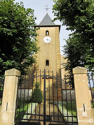
 Saint-Marcel village church |
||
Saint-Marcel is a French commune with 151 inhabitants (as of January 1, 2017) in the Meurthe-et-Moselle department in the Grand Est region (before 2016 Lorraine ). It belongs to the Arrondissement of Briey and the canton of Jarny (until 2015 Conflans-en-Jarnisy ).
geography
The municipality is located about 16 kilometers west of Metz on the border with the Moselle department . Neighboring municipalities are Jouaville in the north, Vernéville (in the Moselle department) in the east, Gravelotte (in the Moselle department) in the southeast, Rezonville-Vionville (in the Moselle department) in the south, Bruville in the west and Doncourt-lès-Conflans in the northwest. The parish consists of the village of Saint-Marcel and the hamlet of Caulre.
history
The place was called Ibliodurum in Roman times and was on the Roman road from Metz to Reims. Historically, Saint-Marcel belonged to the province of Trois-Évêchés (Three Bishoprics), which in fact fell to France in 1552. The municipality was in the old Moselle department until 1871, since then it has been part of the Meurthe-et-Moselle department . From 1871 to 1918 and from 1940 to 1944, Saint-Marcel was a border town with Germany due to its location.
Population development
| year | 1793 | 1800 | 1841 | 1962 | 1968 | 1975 | 1982 | 1990 | 1999 | 2007 | 2015 |
| Residents | 154 | 100 | 207 | 125 | 102 | 105 | 111 | 114 | 146 | 184 | 155 |
| Sources: Cassini and INSEE | |||||||||||
Attractions
- Castle ruins of Château de Villers-aux-Bois
- several farmhouses from the 18th and 19th centuries
- Saint-Marcel village church from the 18th and 19th centuries
- Sainte-Agathe chapel from the 18th century in Caulre
- several wayside crosses in the village center and in Caulre
- numerous interesting tombs in the village cemetery
- Commemorative plaque for the fallen
- Symbolic communal grave for fallen Germans from the Franco-German War
- 19th century Lavoir (wash house) on Route de Mars la Tour
Individual evidence
- ↑ fixed sights
- ↑ moving sights
- ↑ Commemorative plaque for the fallen
- ^ Symbolic communal grave for fallen Germans in the Franco-Prussian War in 1870
