Conflans-en-Jarnisy
| Conflans-en-Jarnisy | ||
|---|---|---|

|
|
|
| region | Grand Est | |
| Department | Meurthe-et-Moselle | |
| Arrondissement | Briey | |
| Canton | Jarny | |
| Community association | Orne Lorraine Confluences | |
| Coordinates | 49 ° 10 ′ N , 5 ° 51 ′ E | |
| height | 185-226 m | |
| surface | 8.71 km 2 | |
| Residents | 2,359 (January 1, 2017) | |
| Population density | 271 inhabitants / km 2 | |
| Post Code | 54800 | |
| INSEE code | 54136 | |
| Website | http://www.conflans-en-jarnisy.fr | |
 Town Hall ( Hôtel de ville ) |
||
Conflans-en-Jarnisy is a French commune with 2359 inhabitants (as of January 1, 2017) in the Meurthe-et-Moselle department in the Grand Est region (until 2015 Lorraine ). It belongs to the arrondissement of Briey and the canton of Jarny , until 2015 it was the capital of the canton of the same name . The inhabitants are called Conflanais .
geography
The municipality in the north of Lorraine is located 20 kilometers west of Metz on the A4 Autoroute in the vicinity of the municipality of Jarny .
history
There were settlements here in Gallo-Roman times. The existence of a castle was documented in 1093 and its destruction in 1636.
Population development
| year | 1962 | 1968 | 1975 | 1982 | 1990 | 1999 | 2009 | 2017 |
| Residents | 2802 | 2850 | 2593 | 2890 | 2728 | 2502 | 2427 | 2359 |
Attractions
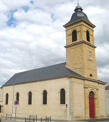
- Church Saint-Martin from 1844
traffic
The railway lines Saint-Hilaire-au-Temple-Hagondange , Longuyon-Pagny-sur-Moselle and Conflans-Jarny-Metz meet at Conflans-Jarny station .
Web links
- Official website of the municipality
- Conflans-en-Jarnisy - Morthomme - Photo comparison 1914–1918 and today

