
Villerupt
| Villerupt | ||
|---|---|---|

|
|
|
| region | Grand Est | |
| Department | Meurthe-et-Moselle | |
| Arrondissement | Briey | |
| Canton | Villerupt | |
| Community association | Pays Haut Val d'Alzette | |
| Coordinates | 49 ° 28 ' N , 5 ° 56' E | |
| height | 309-442 m | |
| surface | 6.56 km 2 | |
| Residents | 9,737 (January 1, 2017) | |
| Population density | 1,484 inhabitants / km 2 | |
| Post Code | 54190 | |
| INSEE code | 54580 | |
| Website | http://www.mairie-villerupt.fr/ | |
 Town Hall ( Hotel de ville ) |
||

Villerupt (German: Weiler or Wyler ) is a north-eastern French municipality with 9737 inhabitants (as of January 1, 2017) located on the Alzette near the border with Luxembourg in the Meurthe-et-Moselle department in the Grand Est region (until 2015 Lorraine ). It belongs to the Arrondissement of Briey and the Canton of Villerupt .
geography
Villerupt is located southeast of Longwy at an altitude between 309 and 442 m above sea level, the mean height is 380 m. The municipality covers 6.56 km². Villerupt includes the districts: Cantebonne (Kantelbronn), Micheville (1576: Micheweiler) and Tutange .
Population development
| year | 1962 | 1968 | 1975 | 1982 | 1990 | 1999 | 2007 | 2014 |
| Residents | 14,377 | 14,797 | 13,401 | 11,465 | 10,070 | 9686 | 9580 | 9430 |
Town twinning
Villerupt partnered with Riesa in Saxony in 1961, with Příbram in the Czech Republic in 1966 and with Aulla in Tuscany (Italy) in 1998.
Culture
The Festival du film italien de Villerupt was launched in 1976. It always takes place at the end of October, in 2013 for the thirty-sixth time.

former ballroom

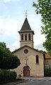
Church of the Nativity of the Virgin Mary ( Nativité-de-la-Vierge )
Holy Cross Chapel ( Sainte-Croix ) in the Cantebonne district

War memorial

Villerupt train station


Personalities
- Aurélie Filippetti (* 1973), French politician ( PS ) and writer
- Olivier Jacque (* 1973), motorcycle racer