
Colmey
| Colmey | ||
|---|---|---|

|
|
|
| region | Grand Est | |
| Department | Meurthe-et-Moselle | |
| Arrondissement | Briey | |
| Canton | Mont-Saint-Martin | |
| Community association | Terre Lorraine du Longuyonnais | |
| Coordinates | 49 ° 28 ' N , 5 ° 33' E | |
| height | 197-352 m | |
| surface | 9.9 km 2 | |
| Residents | 250 (January 1, 2017) | |
| Population density | 25 inhabitants / km 2 | |
| Post Code | 54260 | |
| INSEE code | 54134 | |

Colmey is a French commune with 250 inhabitants (as of January 1, 2017) in the Meurthe-et-Moselle department in the Grand Est region (until 2015 Lorraine ). It belongs to the arrondissement of Briey and the canton of Mont-Saint-Martin (until 2015: canton Longuyon ).
geography
Colmey is located about 80 kilometers north-west of Metz am Chiers . Neighboring municipalities of Colmey are Villette in the north, Longuyon in the east and northeast, Grand-Failly in the south, Petit-Failly in the southwest, Saint-Jean-lès-Longuyon in the west and Charency-Vezin in the northwest.
Population development
| year | 1962 | 1968 | 1975 | 1982 | 1990 | 1999 | 2006 | 2013 |
| Residents | 350 | 341 | 315 | 321 | 273 | 245 | 275 | 264 |
| Source: Cassini and INSEE | ||||||||
Attractions
- L'Assomption-de-la-Vierge church, rebuilt in 1878
- Saint-Hubert church in Flabeuville from the 16th century
- Saint-Hubert chapel, former ossuary, from the 15th / 16th centuries Century, since 1990 Monument historique
- Saint Joseph Chapel
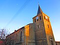
L'Assomption-de-la-Vierge church

Saint-Hubert church
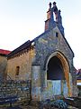
Saint-Hubert chapel

Saint Joseph Chapel


Web links
Commons : Colmey - collection of images, videos and audio files