
Montigny-sur-Chiers
| Montigny-sur-Chiers | ||
|---|---|---|

|
|
|
| region | Grand Est | |
| Department | Meurthe-et-Moselle | |
| Arrondissement | Briey | |
| Canton | Mont-Saint-Martin | |
| Community association | Terre Lorraine du Longuyonnais | |
| Coordinates | 49 ° 29 ′ N , 5 ° 40 ′ E | |
| height | 217-351 m | |
| surface | 9.36 km 2 | |
| Residents | 482 (January 1, 2017) | |
| Population density | 51 inhabitants / km 2 | |
| Post Code | 54870 | |
| INSEE code | 54378 | |
_%C3%A9coles_et_mairie.JPG) Town hall (Mairie) of Montigny-sur-Chiers |
||

Montigny-sur-Chiers is a French commune with 482 inhabitants (as of January 1, 2017) in the Meurthe-et-Moselle department in the Grand Est region (until 2015 Lorraine ). It belongs to the arrondissement of Briey and the canton of Mont-Saint-Martin (until 2015: canton Longuyon ).
Fermont belongs to the municipality .
geography
Montigny-sur-Chiers is located about 80 kilometers northwest of Metz am Chiers . Neighboring municipalities of Montigny-sur-Chiers are Fresnois-la-Montagne in the north, Villers-la-Chèvre in the northeast, Cons-la-Grandville in the east and northeast, Ugny in the east and southeast, Beuveille in the south and Viviers-sur-Chiers in the West and southwest.
Population development
| year | 1962 | 1968 | 1975 | 1982 | 1990 | 1999 | 2006 | 2013 |
| Residents | 665 | 622 | 574 | 511 | 507 | 443 | 465 | 490 |
| Source: Cassini and INSEE | ||||||||
Attractions
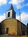
- Saint-Denys church from the 13th century
- Saint-Privat church in Fermont from 1734
- La Roche Chapel
- Fortress of Fermont

Saint-Denys church
Saint-Privat Church


Web links
Commons : Montigny-sur-Chiers - Collection of images, videos and audio files