
Jouaville
| Jouaville | ||
|---|---|---|

|
|
|
| region | Grand Est | |
| Department | Meurthe-et-Moselle | |
| Arrondissement | Briey | |
| Canton | Jarny | |
| Community association | Orne Lorraine Confluences | |
| Coordinates | 49 ° 10 ′ N , 5 ° 57 ′ E | |
| height | 205-322 m | |
| surface | 11.32 km 2 | |
| Residents | 298 (January 1, 2017) | |
| Population density | 26 inhabitants / km 2 | |
| Post Code | 54800 | |
| INSEE code | 54283 | |

Jouaville is a French commune with 298 inhabitants (as of January 1, 2017) in the Meurthe-et-Moselle department in the Grand Est region (until 2015 Lorraine ). It belongs to the Arrondissement of Briey and the Canton of Jarny (until 2015: Canton of Homécourt ).
geography
Jouaville is about 16 kilometers west-northwest of Metz . Jouaville is surrounded by the neighboring communities Moineville in the north and northwest, Batilly in the north, Saint-Ail in the east and northeast, Vernéville in the southeast, Saint-Marcel in the south, Doncourt-lès-Conflans in the southwest and Giraumont in the west.
Population development
| year | 1962 | 1968 | 1975 | 1982 | 1990 | 1999 | 2006 | 2012 |
| Residents | 312 | 305 | 283 | 249 | 268 | 260 | 290 | 319 |
| Source: Cassini and INSEE | ||||||||
Attractions
- Saint-Christophe Church
- Castle of Anoux-la-Grange, remains from the 11th and 12th centuries, in the 14th and 15th centuries. Re-erected in the 18th century, then in a manor during the 18th and 19th centuries. Rebuilt in the 19th century
- numerous crossroads

Saint-Christophe Church
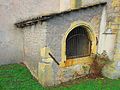
Ossuary at the church


Web links
Commons : Jouaville - collection of images, videos and audio files