
Herserange
| Herserange | ||
|---|---|---|

|
|
|
| region | Grand Est | |
| Department | Meurthe-et-Moselle | |
| Arrondissement | Briey | |
| Canton | Longwy | |
| Community association | Longwy | |
| Coordinates | 49 ° 31 ' N , 5 ° 47' E | |
| height | 258-445 m | |
| surface | 3.54 km 2 | |
| Residents | 4,390 (January 1, 2017) | |
| Population density | 1,240 inhabitants / km 2 | |
| Post Code | 54440 | |
| INSEE code | 54261 | |
| Website | www.mairie-herserange.fr | |
 Town hall ( Mairie ) of Herserange |
||

Herserange ( Luxembourgish Hiirkereng / Hierkeréng ) is a French commune with 4,390 inhabitants (as of January 1, 2017) in the Meurthe-et-Moselle department in the Grand Est region (until 2015 Lorraine ). It belongs to the Arrondissement of Briey and the canton of Herserange , the main town of which it was until 2015. Since then, the municipality has belonged to the Longwy Canton .
geography
Herserange is east of Longwy . Neighboring communities are Longlaville in the north, Saulnes in the east, Hussigny-Godbrange in the southeast and Haucourt-Moulaine and Mexy in the south.
history
The place was first mentioned in 1273 as Herselange (1475: Hertzerangen , 1611: Hersingen ). In 1553 a forge opens in the village. In 1912 six blast furnaces were built, which were shut down in 1988.
Population development
| year | 1962 | 1968 | 1975 | 1982 | 1990 | 1999 | 2006 | 2014 | ||||||
| Residents | 7,492 | 7,044 | 6,626 | 4,918 | 4,240 | 4,327 | 4,347 | 4,353 | ||||||
| Source: Cassini, EHESS and INSEE | ||||||||||||||
Infrastructure
The nearest train station is in Longwy on the Longuyon – Mont-Saint-Martin line .
Attractions
- Parish church of Saints-Pierre-et-Paul, built in 1755
- Parish Church of Notre-Dame-de-Senelle, built in 1924
- Landrivaux Church

Saints-Pierre-et-Paul church
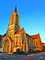
Notre-Dame-de-Senelle church

Landrivaux Church


