
Canton of Conflans-en-Jarnisy
| Former canton of Conflans-en-Jarnisy |
|
|---|---|
| region | Lorraine |
| Department | Meurthe-et-Moselle |
| Arrondissement | Briey |
| main place | Conflans-en-Jarnisy |
| Dissolution date | March 29, 2015 |
| Residents | 19,232 (Jan 1, 2012) |
| Population density | 83 inhabitants / km² |
| surface | 231.05 km² |
| Communities | 25th |
| INSEE code | 5411 |
The canton of Conflans-en-Jarnisy was a French canton in the Arrondissement Briey , in the Département Meurthe-et-Moselle and in the Lorraine region until 2015 ; its main town was Conflans-en-Jarnisy . The last representative in the general council of the department was Olivier Tritz from 2011 to 2015.
The canton of Conflans-en-Jarnisy was 23,105 hectares (231.05 km²) and had (1999) 18,369 inhabitants, which corresponds to a population density of 79.5 inhabitants per km². It was on average at 226 meters above sea level , between 183 m in Giraumont and 314 m in Saint-Marcel .
location
The canton was in the north of the Meurthe-et-Moselle department on its eastern border.

Location of the canton of Conflans-en-Jarnisy in the Meurthe-et-Moselle department
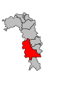
Location of the canton of Conflans-en-Jarnisy in the Arrondissement of Briey


Communities
The canton consisted of 25 municipalities:
| local community | Population year | Area km² | Population density | Code INSEE | Post Code |
|---|---|---|---|---|---|
| Abbéville-lès-Conflans | 225 (2013) | 7.73 | 29 inhabitants / km² | 54002 | 54800 |
| Affléville | 181 (2013) | 9.42 | 19 inhabitants / km² | 54004 | 54800 |
| Allamont | 154 (2013) | 9.06 | 17 inhabitants / km² | 54009 | 54800 |
| Béchamps | 90 (2013) | 9.28 | 10 inhabitants / km² | 54058 | 54800 |
| Boncourt | 196 (2013) | 6.73 | 29 inhabitants / km² | 54082 | 54800 |
| Brainville | 158 (2013) | 9.92 | 16 inhabitants / km² | 54093 | 54800 |
| Bruville | 237 (2013) | 10.81 | 22 inhabitants / km² | 54103 | 54800 |
| Conflans-en-Jarnisy | 2,375 (2013) | 8.71 | 273 inhabitants / km² | 54136 | 54800 |
| Doncourt-lès-Conflans | 1,202 (2013) | 7.34 | 164 inhabitants / km² | 54171 | 54800 |
| Fléville-Lixières | 294 (2013) | 14.38 | 20 inhabitants / km² | 54198 | 54150 |
| Friauville | 367 (2013) | 6.34 | 58 inhabitants / km² | 54213 | 54800 |
| Giraumont | 1,374 (2013) | 7.63 | 180 inhabitants / km² | 54227 | 54780 |
| Gondrecourt-Aix | 182 (2013) | 12.28 | 15 inhabitants / km² | 54231 | 54800 |
| Hannonville-Suzémont | 273 (2013) | 8.68 | 31 inhabitants / km² | 54249 | 54800 |
| Jarny | 8,383 (2013) | 15.60 | 537 inhabitants / km² | 54273 | 54800 |
| Jeandelize | 383 (2013) | 6.75 | 57 inhabitants / km² | 54277 | 54800 |
| Labry | 1,565 (2013) | 5.95 | 263 inhabitants / km² | 54286 | 54800 |
| Mouaville | 102 (2013) | 8.44 | 12 inhabitants / km² | 54389 | 54800 |
| Norroy-le-Sec | 412 (2013) | 13.77 | 30 inhabitants / km² | 54402 | 54150 |
| Olley | 261 (2013) | 9.48 | 28 inhabitants / km² | 54408 | 54800 |
| Ozerailles | 146 (2013) | 6.32 | 23 inhabitants / km² | 54413 | 54150 |
| Puxe | 105 (2013) | 5.89 | 18 inhabitants / km² | 54440 | 54800 |
| Saint-Marcel | 141 (2013) | 11.35 | 12 inhabitants / km² | 54478 | 54800 |
| Thumeréville | 91 (2013) | 7.89 | 12 inhabitants / km² | 54524 | 54800 |
| Ville-sur-Yron | 300 (2013) | 11.30 | 27 inhabitants / km² | 54581 | 54800 |
Population development
| 1962 | 1968 | 1975 | 1982 | 1990 | 1999 | 2006 | 2012 |
|---|---|---|---|---|---|---|---|
| 19,026 | 19,879 | 18,761 | 18,422 | 18,409 | 18,369 | 19,112 | 19,232 |