
Canton of Cirey-sur-Vezouze
| Former canton of Cirey-sur-Vezouze |
|
|---|---|
| region | Lorraine |
| Department | |
| Arrondissement | Luneville |
| main place | Cirey-sur-Vezouze |
| Dissolution date | March 29, 2015 |
| Residents | 3,275 (Jan 1, 2012) |
| Population density | 33 inhabitants / km² |
| surface | 98.65 km² |
| Communities | 7th |
| INSEE code | 5409 |
The canton of Cirey-sur-Vezouze was until 2015 a French canton in the Arrondissement Lunéville , in the Département Meurthe-et-Moselle and in the Lorraine region ; its main town was Cirey-sur-Vezouze , the last representative in the General Council of the department was Josiane Tallotte from 2008 to 2015.
The canton of Cirey-sur-Vezouze was 9,865 hectares (98.65 km²) and had (2006) 3,444 inhabitants, which corresponded to a population density of 35 inhabitants per km². It was on average at 335 meters above sea level , between 273 m in Cirey-sur-Vezouze and 715 m in Saint-Sauveur .
location
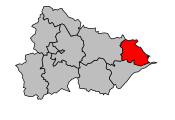
The canton was located in the very south-east of the Meurthe-et-Moselle department on its border.

Location of the canton of Cirey-sur-Vezouze in the Meurthe-et-Moselle department
Location of the canton of Cirey-sur-Vezouze in the Arrondissement of Lunéville


history
A canton of Cirey was first founded in 1790 and was part of the Blâmont district until 1795 . It included the municipalities of Bertrambois, Cirey-sur-Vezouze, Hattigny , Nonhigny , Parux, Petitmont, Raon-lès-Leau , Saint-Sauveur, Tanconville and Val-le-Bon-Moutier . When the administration was reorganized in IX (1800), the canton was dissolved and its previous district was merged with the canton of Lorquin . As a result of the war of 1870–71 , the reestablishment took place with seven communities in the canton of Lorquin (Lörchingen) that remained with France; the municipality of Raon-lès-Leau was attached to the canton of Badonviller (without the large forests that came under the German Empire).
In 2014, the canton was dissolved into the départemental council as part of the electoral reform and the associated municipalities - as well as those of the neighboring cantons of Baccarat, Badonviller and Blâmont - united to form the new canton of Baccarat .
Communities
The canton consisted of seven municipalities:
| local community | Population year | Area km² | Population density | Code INSEE | Post Code |
|---|---|---|---|---|---|
| Bertrambois | 345 (2013) | 18.46 | 19 inhabitants / km² | 54064 | 54480 |
| Cirey-sur-Vezouze | 1,702 (2013) | 16.39 | 104 inhabitants / km² | 54129 | 54480 |
| Parux | 71 (2013) | 4.38 | 16 inhabitants / km² | 54419 | 54480 |
| Petitmont | 339 (2013) | 17.60 | 19 inhabitants / km² | 54421 | 54480 |
| Saint-Sauveur | 56 (2013) | 19.16 | 3 inhabitants / km² | 54488 | 54480 |
| Tanconville | 105 (2013) | 4.09 | 26 inhabitants / km² | 54512 | 54480 |
| Val-et-Châtillon | 623 (2013) | 18.57 | 34 inhabitants / km² | 54540 | 54480 |
Population development
| 1962 | 1968 | 1975 | 1982 | 1990 | 1999 | 2006 | 2012 |
|---|---|---|---|---|---|---|---|
| 4,345 | 4,900 | 4,478 | 3,902 | 3,629 | 3,469 | 3,444 | 3,275 |