
Canton of Domèvre-en-Haye
| Former canton of Domèvre-en-Haye |
|
|---|---|
| region | Lorraine |
| Department | Meurthe-et-Moselle |
| Arrondissement | Toul |
| main place | Domèvre-en-Haye |
| Dissolution date | March 29, 2015 |
| Residents | 13,736 (Jan 1, 2012) |
| Population density | 51 inhabitants / km² |
| surface | 268.83 km² |
| Communities | 27 |
| INSEE code | 5412 |
The Canton Domèvre-en-Haye was 2015 a French canton in the Arrondissement of Toul , in Meurthe-et-Moselle and the region Lorraine ; its main town was Domèvre-en-Haye . The last representative in the General Council of the Département was Jean Loctin from 1994 to 2015.
The canton Domèvre-en-Haye was 26,883 hectares (268.83 km²) and had (1999) 13,233 inhabitants, which corresponded to a population density of 49 inhabitants per km². It was on average at 243 meters above sea level , between 187 m in Liverdun and 354 m in Mamey .
location
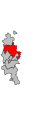
The canton was in the center of the Meurthe-et-Moselle department on its western border.

Location of the canton of Domèvre-en-Haye in the Meurthe-et-Moselle department
Location of the canton of Domèvre-en-Haye in the arrondissement of Toul

Communities
The canton consisted of 27 municipalities:
| local community | Population year | Area km² | Population density | Code INSEE | Post Code |
|---|---|---|---|---|---|
| Andilly | 285 (2013) | 7.12 | 40 inhabitants / km² | 54016 | 54200 |
| Ansauville | 84 (2013) | 6.97 | 12 inhabitants / km² | 54019 | 54470 |
| Avrainville | 198 (2013) | 9.73 | 20 inhabitants / km² | 54034 | 54385 |
| Beaumont | 65 (2013) | 3.11 | 21 inhabitants / km² | 54057 | 54470 |
| Bernécourt | 186 (2013) | 9.38 | 20 inhabitants / km² | 54063 | 54470 |
| Domèvre-en-Haye | 413 (2013) | 8.46 | 49 inhabitants / km² | 54160 | 54385 |
| Francheville | 283 (2013) | 10.94 | 26 inhabitants / km² | 54208 | 54200 |
| Gézoncourt | 170 (2013) | 5.34 | 32 inhabitants / km² | 54225 | 54380 |
| Griscourt | 125 (2013) | 3.74 | 33 inhabitants / km² | 54239 | 54380 |
| Grosrouvres | 54 (2013) | 4.61 | 12 inhabitants / km² | 54240 | 54470 |
| Hamonville | 94 (2013) | 6.66 | 14 inhabitants / km² | 54248 | 54470 |
| Jaillon | 450 (2013) | 7.47 | 60 inhabitants / km² | 54272 | 54200 |
| Liverdun | 5,960 (2013) | 25.25 | 236 inhabitants / km² | 54318 | 54460 |
| Mamey | 341 (2013) | 7.56 | 45 inhabitants / km² | 54340 | 54470 |
| Mandres-aux-Quatre-Tours | 178 (2013) | 10.24 | 17 inhabitants / km² | 54343 | 54470 |
| Manoncourt-en-Woëvre | 250 (2013) | 10.56 | 24 inhabitants / km² | 54346 | 54385 |
| Manonville | 243 (2013) | 9.43 | 26 inhabitants / km² | 54348 | 54385 |
| Martincourt | 95 (2013) | 10.66 | 9 inhabitants / km² | 54355 | 54380 |
| Minorville | 240 (2013) | 12.65 | 19 inhabitants / km² | 54370 | 54385 |
| Noviant-aux-Prés | 265 (2013) | 11.19 | 24 inhabitants / km² | 54404 | 54385 |
| Rogéville | 176 (2013) | 6.94 | 25 inhabitants / km² | 54460 | 54380 |
| Rosières-en-Haye | 245 (2013) | 10.74 | 23 inhabitants / km² | 54463 | 54385 |
| Royaumeix | 346 (2013) | 21.57 | 16 inhabitants / km² | 54466 | 54200 |
| Tremblecourt | 199 (2013) | 6.08 | 33 inhabitants / km² | 54532 | 54385 |
| Velaine-en-Haye | 1,671 (2013) | 17.87 | 94 inhabitants / km² | 54557 | 54840 |
| Villers-en-Haye | 185 (2013) | 7.29 | 25 inhabitants / km² | 54573 | 54380 |
| Villey-Saint-Etienne | 1,109 (2013) | 17.29 | 64 inhabitants / km² | 54584 | 54200 |
Population development
| 1962 | 1968 | 1975 | 1982 | 1990 | 1999 | 2006 | 2012 |
|---|---|---|---|---|---|---|---|
| 7,929 | 8,825 | 10,028 | 11,887 | 12,838 | 13,233 | 13,373 | 13,736 |