
Petite Seille
| Petite Seille | ||
|
|
||
| Data | ||
| Water code | FR : A76-0200 | |
| location |
France
|
|
| River system | Rhine | |
| Drain over | Seille → Moselle → Rhine → North Sea | |
| source | east of Racrange 48 ° 55 ′ 37 " N , 6 ° 40 ′ 45" E |
|
| Source height | approx. 250 m | |
| muzzle | south of Salonnes in the Seille coordinates: 48 ° 47 ′ 9 ″ N , 6 ° 29 ′ 29 ″ E 48 ° 47 ′ 9 ″ N , 6 ° 29 ′ 29 ″ E |
|
| Mouth height | approx. 199 m | |
| Height difference | approx. 51 m | |
| Bottom slope | approx. 2 ‰ | |
| length | approx. 26 km | |
| Catchment area | approx. 155.8 km² | |
| Discharge A Eo : 155.8 km² at the mouth |
MQ Mq |
1.35 m³ / s 8.7 l / (s km²) |
The Petite Seille is an approximately 26 km long right tributary of the Seille in the Moselle department .
geography
course
The Petite Seille rises at a height of about 250 m in two spring branches east of Racrange . After the union of the two spring branches, the Petite Seille flows in a southerly direction past the eastern edge of Racrange. At the Pfaffenhorst grove , which it touches at the western tip, it turns to the southwest and then backs up to the Étang du Moulin . Shortly thereafter, the Ruisseau de Baffel coming from the south flows towards it. It now runs north past Riche and is fed there on its right by the Ruisseau de Pévange coming from the north . At Haboudange she takes on the Ruisseau de la Bonne Fontaine . Downstream they are reinforced by the Ruisseau de Bellange , the Ruisseau de Dahlain and, a little later, the Ruisseau de Kemade . Your direction of flow is now south-southwest. It now reaches Burlioncourt , but flows around it extensively from the east and orientates its course to the south. A few kilometers south it reaches the Ruisseau de Tûche, which has been running parallel to it for a while . The path of the Petite Seille now leads west past Obreck , where its water masses unite with that of the Canal de Bride . North of Hampont , the Petite Seille turns to the west. Shortly before it reaches Hédival , the Ruisseau de Vannecourt, coming from the north, flows towards it. The Canal du Moulin branches off from it at Hédival. It now runs to the southwest and is reinforced by the Ruisseau de Champré and some time later by the Ruisseau de Chypré . It then changes its direction to the south and passes the town of Château-Salins and takes up the Ruisseau de Morville there. Later it crosses Salonnes and finally flows into the Seille at an altitude of 199 m .
Tributaries
- Baffle ( left ), 1.6 km
- Pévange ( right ), 5.2 km
- Bonne Fontaine ( right ), 2.4 miles
- Bellange ( right ), 4.4 km
- Dahlain ( right ), 2.2 miles
- Kemade ( right ), 2.2 km
- Tûche ( right )
- Vannecourt ( right ), 2.5 miles
- Champré ( right ), 2.3 km
- Chypré ( right ), 1.4 km
- Morville ( left ), 2.5 miles
Hydrology
At the confluence of the Petite Seille in the Seille , the mean flow rate (MQ) is 1.35 m³ / s; the catchment area here covers 155.8 km².
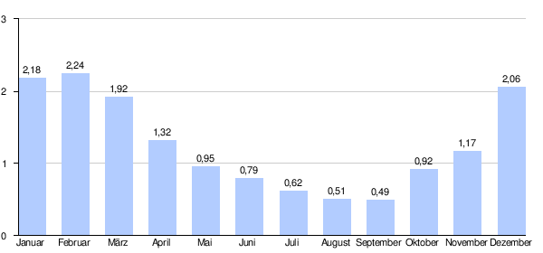
At the Château-Salins gauge, the average annual runoff of the Petite Seille was calculated over a period of 42 years (1969-2010) . The catchment area at this point corresponds to 143 km², which is about 92% of the entire catchment area of the river.
The highest water levels are measured between December and March. The flow rate reached its peak in February at 2.24 m³ / s. From April onwards, the discharge decreases noticeably month after month and reaches its lowest level in September with 0.49 m³ / s, only to increase again from month to month.
The monthly mean discharge (MQ) of the Petite Seille in m³ / s, measured at the hydrological station Château-Salins.
Data calculated from the values for the years 1969–2010
Web links
- Débits caractéristiques de la Petite Seille (French; PDF; 14 kB)
Individual evidence
- ↑ a b geoportail.fr
- ↑ Petite Seille at SANDRE (French)
- ↑ a b see web link: Débits caractéristiques de la Petite Seille
- ↑ Banque Hydro - A7642010 La Petite Seille à Château-Salins (menu item: Synthèse)