French Southern and Antarctic Lands
|
|||
| Basic data | |||
|---|---|---|---|
| Administrative headquarters : | Saint-Pierre on Réunion | ||
| Structure: | 5 districts | ||
| Official language: | French | ||
| Residents: | approx. 200 researchers (winter) | ||
| Surface: | 7676 km² (with Antarctic area 439,676 km²) | ||
| highest elevation: |
Mont Ross (1850 m) (without Antarctic area) |
||
| biggest island: | Île Kerguelen / Grande Terre (6675 km²) |
||
| Prefect : | Cécile Pozzo di Borgo | ||
| Time zones |
UTC + 4 ( Crozet Islands and Îles Éparses ) UTC + 5 ( Kerguelen , Sankt Paul and Amsterdam ) UTC + 10 ( Adélieland ) |
||
| Internet TLD | .tf | ||
| prefix | +262 | ||
| Website: | www.taaf.fr | ||
The French Southern and Antarctic Territories ( French Terres australes et antarctiques françaises , TAAF) are a French overseas territory .
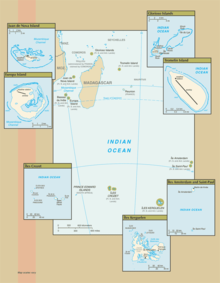
The territory includes the Kerguelen Archipelago, the islands of Amsterdam and Saint Paul , the Crozet Islands , the Adélieland and, since 2007, the tropical Îles Éparses . The fact that Adélieland belongs to the territory is not recognized under international law due to the Antarctic Treaty . In the area south of 60 degrees south latitude, France therefore only exercises its territorial sovereignty within the framework of the provisions of the Antarctic Treaty of 1959 and the Environmental Protection Protocol of the Antarctic Treaty of 1991.
The islands, with the exception of Îles Éparses, are located in the Indian Ocean southeast of Africa and have a total area of 7,633 km² (7,215 km², 352 km², 58 km² and 8 km²). The Antarctic region Adélieland covers an area of 432,000 km², the Îles Éparses are located near Madagascar and have a total area of 43 km².
Prefect and chief administrator of the territory has been Cécile Pozzo di Borgo since 2014, based in Saint-Pierre on Réunion outside the territory. The territory is not part of the European Union , but the euro is the official currency.
The territory has legal capacity , but is not considered a territorial body due to the lack of a permanent population . It has no elected assembly and does not send representatives to the French parliament .
Administrative division
The territory was created in 1955 when the islands of Saint Paul and Amsterdam, the Kerguelen, the Crozet Islands and Adélielands were spun off from what was then the French colony of Madagascar. It was divided into four, since 2007 with the Îles Éparses five districts, which are headed by district administrators. A district administrator's role is similar to that of a French mayor. This includes registration of births and deaths and police duties.
| District | INSEE code | main place | Population (1) | Area [km²] |
EEZ [km²] |
|---|---|---|---|---|---|
| Saint Paul and Amsterdam | 984 11 | Martin de Viviès Station (4) | 29 | 66 | 502,533 |
| Kerguelen | 984 12 | Port-aux-Français (4) | 60 | 7,215 | 563,869 |
| Crozet Islands | 984 13 | Alfred Faure Station (4) | 18th | 352 | 567,475 |
| Adelieland (2) | 984 14 | Dumont-d'Urville Station (4) | 33 | 432,000 | - |
| Iles Éparses (3) | 984 15 | Saint Pierre (5) | 48 | 43 | 640.964 |
| TAAF total | 984 | Saint Pierre (5) | 188 | 439,676 | 2,274,841 |
(1) esteemed personnel of the research stations during the Antarctic winter as well as the crew of the military bases
(2) Adélieland is located on the Antarctic mainland and is therefore subject to the Antarctic Treaty, through which territorial claims have been suspended.
(3) Since February 21, 2007, these islands are incorporated into the territory as the fifth district.
(4) Research station
(5) formal administrative headquarters, located outside the territory on the island of Reunion
geography
The climate is tropical, temperate, sub-Antarctic or Antarctic according to the respective geographical latitude. The islands are predominantly of volcanic origin. The highest point of the islands is the Mont Ross on the Kerguelen with 1850 m. Large parts of Adélieland reach heights of more than 2000 m because of the thickness of the Antarctic ice sheet .
Residents
The area has no permanent residents. Around 140 researchers spend the winter in four Antarctic and sub-Antarctic research stations. This number can double during the summer months.
In addition, there is the occupation of the military bases on three of the Îles Éparses, which total 45, and the three-man civilian crew on Tromelin .
economy
The economic life of the areas is very low. It mainly concerns the construction and maintenance of the research stations. The islands also serve as a starting point for fishing . The main trading partner is France. TAAF has been issuing its own postage stamps since 1955 .
Web links
- Terres australes et antarctiques françaises (TAAF). Official website of the French Southern and Antarctic Lands. Administration des Terres australes et antarctiques françaises (TAAF) (French).
- Terres australes et antarctiques françaises - Les TAAF. Website of the French overseas ministry, Ministère des Outre-mer (French).
- Terres Australes et Antarctiques. In: France.fr - official website for tourism in France. Atout France, the French tourist office.
- Philately - timbres. In: anciensite.taaf. Postal addresses of the eight stations in the area (French)
Individual evidence
- ↑ Taaf - presentation. In: anciensite.taaf. Administration des Terres australes et antarctiques françaises (TAAF), archived from the original on July 15, 2016 ; Retrieved on August 27, 2017 (French, old version of the TAAF official website).
- ↑ European Central Bank : FAQs on Circulation - Where is the Euro legal tender? ( Memento of February 27, 2007 in the Internet Archive ). Retrieved August 27, 2017.


