Saint-Pierre (Réunion)
| Saint-Pierre | |
|---|---|

|

|
| region | Reunion |
| Department | Reunion |
| Arrondissement | Saint-Pierre |
| Canton |
Saint-Pierre-1 Saint-Pierre-2 Saint-Pierre-3 |
| Community association | Villes Solidaires |
| Coordinates | 21 ° 21 ′ S , 55 ° 29 ′ E |
| height | 0-1,642 m |
| surface | 95.99 km 2 |
| Residents | 84,212 (January 1, 2017) |
| Population density | 877 inhabitants / km 2 |
| Post Code | 97410 |
| INSEE code | 97416 |
| Website | http://ville-saintpierre.fr/ |
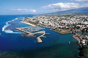
 View over Saint-Pierre |
|
Saint-Pierre is a commune in the overseas department of Réunion in France . It has been the main town ( sub-prefecture ) of the arrondissement of the same name since 1965 . Saint-Pierre has 84,212 inhabitants (as of January 1, 2017), making it one of the 50 most populous municipalities in France. Saint-Pierre is the center of the Communauté d'agglomération Communauté Intercommunale des Villes Solidaires (CIVIS).
geography
Saint-Pierre is located in the southwest of Réunion. It borders the municipalities of Entre-Deux , Petite-Île , Saint-Joseph , Saint-Louis and Le Tampon .
TAAF administrative headquarters
The Prefect and Chief Administrator of the French Southern and Antarctic Lands (TAAF), Pascal Bolot since 2012 , is based in Saint-Pierre and administers the area from Réunion.
Infrastructure
The port of Saint-Pierre was completed in 1882 after 30 years of construction. In the same year, a railway line was also opened that connects the municipality with Saint-Louis .
The city's Stade Michel-Volnay is home to the most successful football club on the island, JS Saint-Pierre .
sons and daughters of the town
- Michel Houellebecq (* 1956 or 1958), writer
- Jackson Richardson (born 1969), handball player
- Guillaume Hoarau (* 1984), football player
- Florent Sinama-Pongolle (* 1984), football player
- Valérie Bègue (* 1985), Miss France 2008
- Dimitri Payet (* 1987), football player
- Donavan Grondin (* 2000), cyclist
Web links
- Website of the municipality (French)