
Entre-Deux
| Entre-Deux | |
|---|---|
.svg)
|

|
| region | Reunion |
| Department | Reunion |
| Arrondissement | Saint-Pierre |
| Canton | Saint-Louis-2 |
| Community association | South |
| Coordinates | 21 ° 15 ′ S , 55 ° 28 ′ E |
| height | 109-2,352 m |
| surface | 66.83 km 2 |
| Residents | 6,902 (January 1, 2017) |
| Population density | 103 inhabitants / km 2 |
| Post Code | 97414 |
| INSEE code | 97403 |
| Website | www.village-entredeux.fr |
 View to the coast |
|
Entre-Deux is a French commune in the interior of the overseas department of La Réunion . It was the capital of the canton Entre-Deux until its dissolution in 2015 and has since been part of Saint-Louis-2 in the Arrondissement of Saint-Pierre and has 6902 inhabitants (as of January 1, 2017).
geography
The municipality is located in the interior of the island of Réunion between the two tributaries of the Rivière Saint-Étienne : the Bras de Cilaos in the west and the Bras de la Plaine in the east. It borders on the neighboring communities of Cilaos , Saint-Benoît , Saint-Louis , Saint-Pierre and Le Tampon .
History and administration
- In 1839 the area of today's municipality becomes the 5th section of St. Pierre
- 1882 Entre-Deux is founded
- Bachil Moussa Valy has been the mayor since 2001
Demographics
| year | 1967 | 1974 | 1981 | 1990 | 1999 | 2006 | 2009 |
|---|---|---|---|---|---|---|---|
| Residents | 3 723 | 3 745 | 3 705 | 4260 | 5 170 | 5 713 | 6 176 |
Infrastructure
There is the Collège Le Dimitile in the municipality , with 412 students
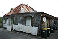
historic creole house


Web links
Commons : Entre-Deux - collection of images, videos and audio files
- Village-entredeux.fr Website of the municipality
- Site Tourist Office of Entre-Deux .
Individual evidence
- ↑ Entre-deux at the Insee statistics office ( page no longer available , search in web archives ) Info: The link was automatically marked as defective. Please check the link according to the instructions and then remove this notice.