Vailly-sur-Sauldre
| Vailly-sur-Sauldre | ||
|---|---|---|

|
|
|
| region | Center-Val de Loire | |
| Department | Cher | |
| Arrondissement | Bourges | |
| Canton | Sancerre | |
| Community association | Pays Fort Sancerrois Val de Loire | |
| Coordinates | 47 ° 28 ' N , 2 ° 39' E | |
| height | 188-273 m | |
| surface | 18.25 km 2 | |
| Residents | 654 (January 1, 2017) | |
| Population density | 36 inhabitants / km 2 | |
| Post Code | 18260 | |
| INSEE code | 18269 | |
| Website | www.vailly-sur-sauldre.com/accueil | |
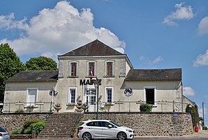
 Mairie Vailly-sur-Sauldre |
||
Vailly-sur-Sauldre is a French municipality with 654 inhabitants (at January 1, 2017) in the department of Cher in the region Center-Val de Loire . It belongs to the Arrondissement of Bourges and belongs to the canton of Sancerre .
geography
The municipality is crossed by the Sauldre river and its tributary Salereine also flows here. Neighboring municipalities of Vailly-sur-Sauldre are Pierrefitte-ès-Bois in the northeast, Sury-ès-Bois in the east, Thou in the south, Villegenon in the southwest, Dampierre-en-Crot in the west and Barlieu in the northwest.
Population development
| year | 1962 | 1968 | 1975 | 1982 | 1990 | 1999 | 2012 |
| Residents | 814 | 759 | 741 | 856 | 865 | 806 | 786 |
Attractions
- Castle ruins (13th to 16th centuries)
- Saint Martin Church
literature
- Le Patrimoine des Communes du Cher. Flohic Editions, Volume 2, Paris 2001, ISBN 2-84234-088-4 , pp. 1016-1021.
Web links
Commons : Vailly-sur-Sauldre - Collection of images, videos and audio files

