
Lunery
| Lunery | ||
|---|---|---|
|
||
| region | Center-Val de Loire | |
| Department | Cher | |
| Arrondissement | Bourges | |
| Canton | Chârost | |
| Community association | Fercher Pays Florentais | |
| Coordinates | 46 ° 56 ' N , 2 ° 16' E | |
| height | 121-173 m | |
| surface | 32.87 km 2 | |
| Residents | 1,570 (January 1, 2017) | |
| Population density | 48 inhabitants / km 2 | |
| Post Code | 18400 | |
| INSEE code | 18133 | |
 Town Hall (Mairie) of Lunery |
||

Lunery is a commune with 1,570 inhabitants (as of January 1 2017) in the department of Cher in the region Center-Val de Loire . It belongs to the Arrondissement of Bourges and the Canton of Chârost .
geography
Lunery is about 19 kilometers south-southwest of Bourges on the Cher . Lunery is surrounded by the neighboring communities of Saint-Florent-sur-Cher in the north, Saint-Caprais in the east and north-east, Lapan in the south and east, Primelles in the west and south-west and Civray in the west and north-west.
Population development
| year | 1962 | 1968 | 1975 | 1982 | 1990 | 1999 | 2006 | 2013 |
| Residents | 2,392 | 2,329 | 2,440 | 2,021 | 1,665 | 1,536 | 1,487 | 1,459 |
| Source: Cassini and INSEE | ||||||||
Attractions
- Saint-Privé church, originally from the 11th century, today's construction mainly from the 13th century
- Saint-Albert church from the 19th century
- Champroy Castle
- La Vergne mansion from the 15th century
- Ruins of a water mill from the 15th century

Saint-Privé church
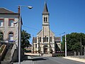
Saint Albert Church

Ruins of the watermill in Rosières


Personalities
- Georges Valbon (1924–2009), politician (PCF)
- Philippe Mahut (1956-2014), football player
literature
- Le Patrimoine des Communes du Cher. Flohic Editions, Volume 1, Paris 2001, ISBN 2-84234-088-4 , pp. 281-285.
Web links
Commons : Lunery - collection of pictures, videos and audio files