Baugy (Cher)
| Baugy | ||
|---|---|---|

|
|
|
| region | Center-Val de Loire | |
| Department | Cher | |
| Arrondissement | Bourges | |
| Canton | Avord | |
| Community association | La Septaine | |
| Coordinates | 47 ° 5 ' N , 2 ° 44' E | |
| height | 157-202 m | |
| surface | 47.78 km 2 | |
| Residents | 1,721 (January 1, 2017) | |
| Population density | 36 inhabitants / km 2 | |
| Post Code | 18800 | |
| INSEE code | 18023 | |
| Website | baugy18.com | |
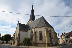
 Saint Martin Church |
||
Baugy is a commune with 1,721 inhabitants (as of January 1 2017) in the department of Cher in the region Center-Val de Loire . It belongs to the Arrondissement of Bourges and the Canton of Avord .
It was created as a Commune nouvelle of the same name with effect from January 1, 2019 through the amalgamation of the previous municipalities of Baugy , Laverdines and Saligny-le-Vif , which have the status of a Commune déléguée in the new municipality . The administrative headquarters are in Baugy.
structure
| District | former INSEE code |
Area (km²) | Population as of January 1, 2017 |
|---|---|---|---|
| Baugy (administrative headquarters) | 18023 | 22.60 | 1,501 |
| Laverdines | 18123 | 9.89 | 42 |
| Saligny-le-Vif | 18239 | 15.29 | 178 |
geography
Baugy is in the Berry countryside , about 25 kilometers east of Bourges . Baugy is surrounded by the neighboring municipalities of Villabon in the north and northwest, Gron in the north, Villequiers in the northeast, Chassy in the east, Nérondes in the southeast, Bengy-sur-Craon and Avord in the south and Farges-en-Septaine in the west.
Web links
Individual evidence
- ↑ Decree of the Prefecture No. 18-2018-10-18-001 on the formation of the Commune nouvelle Baugy of October 18, 2018.
- ↑ current population according to INSEE
