
Pliensauvorstadt
|
Pliensauvorstadt
City of Esslingen am Neckar
Coordinates: 48 ° 44 ′ 7 ″ N , 9 ° 17 ′ 50 ″ E
|
|
|---|---|
| Height : | 257 m |
| Residents : | 6735 (Jun. 30, 2016) |
| Postal code : | 73734 |
| Area code : | 0711 |
  Location of Pliensauvorstadt in Esslingen am Neckar
|
|
Pliensauvorstadt is a district of Esslingen am Neckar . It is somewhat isolated in the south of the city on the other side, the left bank of the Neckar . The Pliensau Bridge for pedestrians and cyclists and the Vogelsang Bridge for vehicles lead from the city center to the Pliensauvorstadt.
history
The historic Pliensauvorstadt
The area south of today's Wehrneckar was originally considered Pliensauvorstadt, which was drained, built on and finally incorporated into the city through an extension of the city wall in the 13th century as an extension of the Staufer city. The Pliensauvorstadt was accessible from the old town via the Inner Bridge, which was newly built from stone after 1286. At the same time, another bridge, the Äußere- or Pliensau Bridge, was built until 1296 as an extension of the Inner Bridge and the main river of the Neckar, which previously ran through today's Wehr- and Roßneckar, was moved under this bridge. The Pliensaustraße, or Pliensau for short, still reminds of this historic Pliensau suburb. The name 'Pliensau' goes back to an Alemannic leader named Pleono.

The Pliensau Bridge was built between 1286 and 1296 and integrated with three towers into the fortifications of the historic Pliensauvorstadt. It is one of the oldest preserved arch bridges north of the Alps. Its middle tower was demolished in 1819 and the outer one in 1837. In the course of the canalization of the Neckar in the 1970s, part of the bridge was demolished and replaced by a steel structure.
With the construction of the Pliensau Bridge, the road between Esslingen and Bad Cannstatt was relocated to the left bank of the Neckar, which gave the Pliensau Bridge a strategically important importance in the Middle Ages : Anyone who wanted to rule over access to the Inner Swabian region had to own the Pliensau Bridge and Esslingen. Because this bridge was now on the way of the long-distance traders on the way between the major economic centers of Flanders and Northern Italy .
The modern Pliensauvorstadt
At the time of the imperial city of Esslingen, the place of execution was the place of the modern Pliensauvorstadt .
From 1865 an industrial area was laid out there, around which the mansions of the manufacturers were initially grouped. Around 1900 the Pliensauvorstadt was a preferred residential area for wealthy families, as is still the case today. B. at the listed villa colony in Berkheimer Str. Can be seen. Workers' apartments followed and, after the Second World War , apartments for displaced persons. After most of the larger industrial companies moved away, a mixed area of apartments and smaller companies was created in Pliensauvorstadt.
With the construction of Bundesstraße 10 , the district's direct access to the Neckar was cut off and Pliensauvorstadt was long referred to as the “Gypsy Island”, and in the 1970s and 1980s also as “The Bronx”. In the meantime, however, due to extensive renovations and many new buildings, it has become a more attractive residential area close to the city center.
After pedestrians had only been able to reach the city via detours for over 2 years, there has been a direct connection between the Pliensauvorstadt and the Esslingen city center since October 2007 through a new bridge over the railway tracks. For this purpose, a new pedestrian bridge was laid on the night of July 21st to 22nd.
The Berber village

Since the mid-1980s, a small green space between the Neckar and the heavily frequented B 10 has served as a residential area for Berbers, tolerated by the city of Esslingen . Access is only possible from the Vogelsang Bridge. First a Berber erected a tent on a small area west of the Pliensau Bridge and covered it with tarpaulin in winter . In the following spring he erected a larger tent in the same place with a small flower-decked veranda , which he in turn protected from precipitation with several tarpaulins . In the period that followed, more homeless people were able to develop the area east of the Pliensau Bridge. The city then made construction trailers available to the Berbers in the winter months . In the summer months, the construction trailers were dismantled by the city and the Berbers had to pitch their tents again. An attempt was made to draw attention to the housing shortage and homelessness with a nationwide unique project : The Berbers built an eleven meter long and six meter wide catamaran and placed a 4.50 meter high red backpack on it instead of a cabin . This was erected as a memorial on the river side opposite in the park of the Villa Merkel and a trip to the former federal capital was planned. Despite financial difficulties, the trip over Neckar and Rhine to Bonn was successfully undertaken by the Berbers in 1991 as part of the action art of the Esslingen association Kultur am Rande . The catamaran was then docked under the Pliensau Bridge for a while, but was then recycled by the homeless, so that in the meantime only pieces of wreckage remained. Instead of the originally mobile construction trailers and tents, the Berbers were able to build barracks that could be used all year round .
politics
The contact person for the issues of the district for the city administration and the municipal council of Esslingen is the citizens' committee Pliensauvorstadt . At the district level, the citizens' committee helps shape community life. He is a member of the working group of citizens 'committees , which exists to exchange experiences and coordinate the individual citizens' committees of the city. The basis for the working method and the structure of the citizens' committee and the working group is the status adopted by the working group on February 21, 1991 . An agreement was reached as the basis for the cooperation between the citizens' committee, the municipal council and the administration . This was approved by the working group on July 17, 1990 and approved by the municipal council on December 10, 1990. In June 2000, both the status and the agreement were editorially revised.
The citizens 'committee is elected for 3 years in a public citizens' meeting held by the city of Esslingen .
schools
- Pliensau school (elementary school)
- Adalbert-Stifter School (Werkrealschule)
- Free Waldorf School Esslingen
- International Federation Education Center
Attractions
- The former Roser leather factory (built in 1875)
- The Pliensau School (built in 1913)
- The Evangelical South Church (built 1925/26)
- The Catholic Church of St. Elisabeth (built 1964 to 1966)
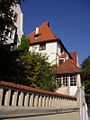
- The ten villas on Berkheimer Straße (built 1904 to 1910)
See also: Ehnisgasse

Former Roser leather goods factory

Pliensau school

South church

St. Elisabeth Church

Villa on Berkheimer Strasse
Villa on Berkheimer Strasse


Web links
- District guide Pliensauvorstadt
- Pictures from the Pliensauvorstadt
- District portrait: history - now - future
- Citizens Committee members and priorities
Individual evidence
- ↑ Development of the resident population in the districts 2006-2016 As of June 30th each year. City of Esslingen, accessed on April 28, 2017 .
- ↑ Kultura: " Culture is how the whole person lives: Backpack memorial 1990/91 " (September 25, 1991)
- ^ Citizens' committees in Esslingen am Neckar
- ^ Statute of the Citizens' Committees Esslingen am Neckar
- ^ Agreement on cooperation between the citizens' committees and the Esslingen am Neckar municipal council and administration

Berkheim | Brühl | Hegensberg | Hohenkreuz | Downtown | Kennenburg | Kimmichsweiler / Oberhof | Krummenacker | Liebersbronn | Mettingen | Neckarhalde | Oberesslingen | Obertal | Pliensauvorstadt | Rudders | Sankt Bernhardt | Zerach | Sirnau | Sulzgries | Wäldenbronn | Because | Wiflingshausen | Cell | Zollberg