Illerkanal
| Illerkanal | |
|---|---|
|
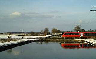
Bridge over the Illerkanal at Tannheim station (2006) |
|
| location | Germany: Bavaria and Baden-Württemberg |
| length | 41 km |
| Built | 1910 |
| Beginning | Junction from the Iller near Ferthofen |
| The End | Confluence with the Iller near Illerzell |
| Descent structures | Several locks between Ferthofen and Illerzell |
| Used river | Iller |
| Outstanding structures | Illerkraftwerke of EnBW |
As Illerkanal two water channels are called, which for energy parallel to the Iller were built in the years from 1910 and in the years 1919 to 1927. The EnBW , the LEW and other companies operate more with him hydroelectric power plants .
course
The upstream canal structure begins as a left branch from the Iller near Mooshausen , a district of Aitrach , and is returned to the Iller after about 20 kilometers near Kirchberg an der Iller . In this section there are four EnBW Illerkraftwerke : IKW II near Tannheim , IKW III near Unteropfingen , IKW IV near Dettingen and the small hydropower plant Mooshausen.
The second Illerkanal, which was completed in 1910, branches off approx. 900 meters downstream at Filzingen , a district of Altenstadt (Iller), to the right of the Iller and flows into the Danube after approx. 31 kilometers in Neu-Ulm . In the upper part, "Untere Iller AG" (UIAG), a subsidiary of LEW and E.ON Wasserkraft , operates three hydropower plants in Altenstadt , Untereichen and Au . After an outflow towards the Iller at canal kilometer 12, the Illerkanal is temporarily also referred to as the "Wieland Canal", as it runs directly through the premises of the Wieland works , which operate a company-owned hydropower plant on their premises. In the city of Neu-Ulm, the Stadtwerke Ulm / Neu-Ulm (SWU) operate the Ludwigsfeld hydropower plant and the Neu-Ulm hydropower plant.
In the last section, shortly before the confluence with the Danube, there is the canoe slalom course of the "Ulmer Paddler", which is also used by the association "Ulmer Kanufahrer eV".
history
In the years 2010 to 2012, the existing bridge over the left-hand Illerkanal and the A7 near Kirchdorf an der Iller was demolished and a new bridge was built for around 6 million euros . In the following year, 2013, the owner renewed the inlet structure on the Illerkanal near the Mooshausen weir. That is why the canal was drained to the Tannheim power station.
literature
- Albert Haug: Illerkanal cultural landscape . Süddeutsche Verlagsgesellschaft, Ulm 2010, ISBN 978-3-88294-411-2 .
Web links
- Regional Council Tübingen
- Non-profit supply of electricity - The District Association of Oberschwäbische Elektrizitätswerke (OEW) 1909–1939 By Kurt Diemer (PDF; 205 kB)
Individual evidence
- ↑ Program for the “100 Years Illerkanal Association” (PDF document). (PDF; 4 kB) Retrieved April 15, 2012 .
- ↑ EnBW is renewing the inlet structure on the Illerkanal at the Mooshausen weir. (No longer available online.) Archived from the original on July 14, 2014 ; Retrieved June 11, 2014 . Info: The archive link was inserted automatically and has not yet been checked. Please check the original and archive link according to the instructions and then remove this notice.
- ↑ Untere Iller AG (UIAG) invests in ecological measures on the Iller ( Memento of the original from July 14, 2014 in the Internet Archive ) Info: The archive link has been inserted automatically and has not yet been checked. Please check the original and archive link according to the instructions and then remove this notice. October 26, 2009, accessed June 11, 2014
- ↑ Wieland environmental statement 2012, Vöhringen plant, accessed on June 11, 2014
- ↑ The hydropower plants of the SWU ( Memento of the original from July 14, 2014 in the Internet Archive ) Info: The archive link was inserted automatically and has not yet been checked. Please check the original and archive link according to the instructions and then remove this notice. Retrieved June 11, 2014
- ↑ themenportal.de: EnBW is renewing the intake structure on the Illerkanal at the Mooshausen weir ( memento of the original from July 14, 2014 in the Internet Archive ) Info: The archive link was automatically inserted and not yet checked. Please check the original and archive link according to the instructions and then remove this notice. dated June 26, 2013, accessed July 20, 2013
Coordinates: 47 ° 59 ′ 11.1 ″ N , 10 ° 6 ′ 13.4 ″ E
