
Castle Schlossau
| Castle Schlossau | |
|---|---|
| limes | ORL 51 ( RLK ) |
| Route (RLK) | ORL route 10 Neckar-Odenwald-Limes Odenwald line |
| Dating (occupancy) |
Trajan until at least 158 AD |
| Type | Numerus fort |
| unit | Numerus Brittonum Triputiensium |
| size | 80 × 73 meters = 0.58 ha |
| Construction | a) wood-earth-wall b) stone wall |
| State of preservation | slight bump |
| place | Mudau- Schlossau |
| Geographical location | 49 ° 32 '26 " N , 9 ° 8' 58" E |
| height | 520 m above sea level NHN |
| Previous | Seitzenbuche small fort (northwest) |
| Subsequently | ORL 52 Oberscheidental Castle (south) |
The castle Schloßau was a Roman numerus fort of the older Odenwald line of the Neckar-Odenwald-Limes . It is located on the northern edge of the center of Schloßau, a district of the municipality of Mudau in the Neckar-Odenwald district in Baden-Württemberg . As a result of the archaeological excavations carried out in the first decade of the 21st century , the vicus of Schloßau is currently the best-researched civil settlement of a Roman fort on the Odenwald Limes.
location

The fort was built in a clear Limes bend at an extensive height, which forms large, steeply sloping land tongues to the west and northwest in the area of the Roman border system and flows into narrow valleys at its foot. Schloßau lies on a flat hilltop, descending to the east, which is at the beginning of a mountain spur stretching to the northwest. Coming from a somewhat more westerly direction, the Limes ran across this spur and turned south at the fort. The crew could make out the Limes watchtower Wp 10/38 at the highest point of the hilltop to the west and see several towers in the south. In the east, already outside the realm of the Reich, the access to a short, steeply to the northwest sloping terrain incision in the Ernsttaler Grund could be seen.
Due to the results of the excavations in the Roman camp village belonging to the garrison between 2003 and 2007, the course of the Limes near Schloßau assumed since 1926 is no longer valid. Otherwise it would not only have run directly on the north-western corner of the fort, in the area of the trench, but would have cut across the settlement south of the camp. It is now assumed that the border line ran around 120 meters to the east than previously thought.
Research history

The field name Burggewann already indicates a long tradition of this military site. Most likely, the town of Schloßau , mentioned in a document as Slozzahe in 1271, can still be brought into line with the old fort, the remains of which may have existed into the Middle Ages. A Heinrich uff der pfalcz zu Shoßauwe is mentioned for 1413 . This Palatinate could have existed in the area of the ancient garrison. Even during the first excavations, which were carried out in 1809 on behalf of Count Franz I of Erbach-Erbach , only a few remains of the Roman complex could be found. Further excavations were carried out in 1863 and 1866 by the Buchener Altertumsverein and around 1900 by the Imperial Limes Commission . The fort vicus , the typical camp village for Roman military installations , was located between the camp and today's town center . In this area, about 60 meters south of the camp fence, the antiquity association discovered the fort bath as early as 1863, which was re-examined in 1897. From 2003 to 2007, the State Monuments Office of Baden-Württemberg conducted new investigations in the area of the vicus under the direction of Britta Rabold . The excavation results indicate at least three phases of construction or use. Thanks to these excavations, the vicus of Schloßau is the best-researched fort vicus on the Odenwald Limes.
Building history
The rectangular, 80 × 73 meter (= 0.58 hectare) castle Schloßau is a typical numerus castle. A wood-earth warehouse built in the Trajan period was later followed by a stone structure at this point. The garrison was given up no later than when the Limes moved forward around 159 AD.
The garrison's defensive wall, which was once surely crowned by battlements, was measured to be between 0.90 and 1.20 meters wide. The floor plan has the rounded corners typical of forts from the middle imperial era, in which no traces of possible stone towers were apparent during the excavations. Only at the single-lane Porta praetoria , the main gate of the complex, and at the structurally very similar south gate, the Porta principalis dextra , could at least traces of the two flanking gate towers be made out. The camp had a total of three gates; In addition to the Porta praetoria facing east towards the Limes, the Porta principalis sinistra, likewise with only one driveway and two towers, was located opposite the south gate on the north enclosure of the camp . The fort was surrounded by a five to six meter wide moat that was 1.5 meters deep when it was excavated. The excavation of the trench was poured onto the defensive wall inside the camp and used as a battlement path in the form of an earth ramp. To prevent this ramp from sliding down, the Roman workers built a small wall at the foot of the rampart. Along this little wall in Schloßau the Via sagularis , the Lagerringstraße completely encircling the fort, is assumed.
Inside the camp, only a few traces of the former interior buildings have survived. As usual for military buildings of this time, the center of the fort was dominated by an administration and staff building, the Principia . The excavators were only able to find a few traces of this largely standardized structure in Schloßau. A four-walled area open to the east can be seen as a demarcation of the former rectangular inner courtyard, which in Roman times was surrounded by longitudinal administrative wings. Only the 5 × 5 meter large and solidly walled flag sanctuary to the west, in the rear part of the Principia , as well as the two adjacent rooms on the left and right are other known architectural remains. A well was uncovered between the staff building and the east gate. Otherwise only small traces of the half-timbered interior could be found.
Today the fort shows itself only as a weak track in the ground.
Fort bath

The 25 meter long bathing building was located around 60 meters southeast of the Porta principalis dextra . The excavated remains are designed in the manner of Roman baths in a row, as they are known in a similar form from other border fort sites. The fort baths were most likely also used by the local residents of the camp villages. During his excavation, brick stamps of the Legio XXII Primigenia pia fidelis (22nd Legion "Primigenia", dutiful and faithful ) stationed in Mogontiacum (Mainz) and the Legio VIII Augusta (8th Legion "Augusta") located in Argentoratum (Strasbourg) were found . It can be assumed that these legions were either on site with construction crews or at least supplied building materials. The bathroom was entered from the north, a possible apodyterium (changing room) is missing. During the excavations of the 19th century it was mostly not possible to identify wooden extensions in the ground. Due to newer excavation methods it is now known that a number of military baths had half-timbered extensions. Perhaps such an extension with changing facilities was in front of the Schloßauer Bad. After entering, those looking for relaxation stood in the rectangular frigidarium (cold bath). To the east there was still a small annex room , also a cold bath, to the west a large, heated semicircular apse, the sudatorium (sweat bath), could be entered. Further south there was a narrow corridor that ran across the longitudinal axis of the thermal bath. In its underground a large sewer ran from the building to the east. The next room was a tepidarium (leaf bath) , followed by a caldarium (warm bath). Behind the south wall of the caldarium was the praefurnium (boiler room), from which the rooms were heated. Due to the slight slope, the builders erected four support pillars on the east facade in the form of protruding wall pillars.
Troops and military personnel

A remarkable find is a consecration altar discovered in 1850, which provides valuable information about the auxiliary troops stationed in Schloßau . According to the inscription, it was donated by Centurion Titus Manius Magnus , who came from Sinope , a Black Sea town in Paphlagonia . This officer was of the niedermösischen Troesmis lying Legio V Macedonica (5th Macedonian Legion) on the lower Danube to Legio XXII Primigenia in Mainz (Mogontiacum) came and was well off from there as commander of Schloßau. Here he commanded the local crew, an auxiliary force called Numerus Brittonum Triputiensium .
On the basis of different findings, the research discusses that the Brittonen units, in contrast to the other troop units, during and after the construction of the new border fortifications, some 20 to 30 kilometers further east, possibly until at least 158 AD, on Odenwald Limes remained. An altar of the Elzbrittonen in the Odenwald fort bath Neckarburken dates from this year . It seems that the Odenwald towers were at least partially kept up in the early second half of the 2nd century, as indicated by ceramic finds from the Limes watchtower Wp 10/54, which are generally dated to the period after 150 AD . Eventually, organizational stage services for the new Limes line had to be done and the final evacuation of the old military installations had to be prepared. The assumption that the Brittons and the other auxiliary troops were brought forward separately stands or falls with the assumption that the surviving inscription of the governor Gaius Popilius Carus Pedo, who was in office from 152 to 155 AD, which mentions special military tasks for these years, is actually the Reorganize and move the troops forward to the new, Vorderen Limes thinks. The fact is that the oldest absolutely datable dendrochronological data in the area of the new border line comes from the Osterburkener station of the local road police ( beneficiaries ) and shows this for the year 159 AD. What is certain is that the Schloßauer Numerus Brittonum Triputiensium was brought forward to the newly built fort of Miltenberg on the Main ( Fort Miltenberg-Altstadt ) at the latest by 159/160 AD .
Vicus
.jpg)


The vicus , the civil settlement of the fort, in which the entourage of the troops, members of soldiers, traders, craftsmen, innkeepers, joy girls and other service providers settled, extended in Schloßau primarily south of the fort. It had already been suspected there by the Reichs-Limeskommission and could be proven by the excavations from 2003 to 2007 up to a distance of almost 400 m south of the Porta principalis dextra and up to a width of almost 200 m. The central axis was the up to six meters wide, paved arterial road that came from the fort, passed the thermal baths, crossed the vicus and then continued to the Oberscheidental fort. The previously uncovered settlement area began approximately at the level of the fort thermal baths. A total of three construction phases could be distinguished.
Phase 1
The first phase included the fort bath, blacksmiths' dinners as well as a few pottery kilns and a 19.50 meter long brick kiln excavated in 2003. The twenty stamped bricks recovered from the backfill and the chimney of the brick kiln point to a construction team of Legio XII Primigenia , who probably moved into quarters here to build the fort. Interestingly, most of the stamps have a completely different appearance. The first, three to four meter wide construction phase of Vicusstrasse, as well as a larger building of unknown purpose south of the street, also belong to the stage of early settlement. In 2004, a rectangular furnace with two chambers was uncovered, which according to the experts is to be assigned to the first phase of use and which was used for metal processing, as forge slag was also preserved there.
Phase 2
Probably only in the second construction phase was the vicus occupied by its later residents. This is supported by some 20-meter-long strip houses erected in this phase , which were built using half-timbered construction technology along the paved street, which is now five to six meters wide. The uniformity of the hearths in the houses speaks in favor of a schematically planned system, similar to today's row house construction.
Phase 3
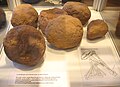
For phase 3, four perfectly preserved pottery ovens with perforated tennis courts, which also came to light in 2003, are expected. The good state of preservation was due to the fact that the ovens were sunk into the rock. The archaeologists found 20 deformed pots, known as false fires, in one of the ovens . Apparently the stove had overheated and was destroyed. In another of these ovens, a small terracotta figure was found in the backfill of its service pit, depicting a rooster and which was most likely made as a children's toy.
The grave field was mainly to the east of the arterial road, according to Roman custom outside of the populated area.
The Vicus was on the task of the fort and the laying of the humerus to the Upper Germanic Limes continued to be inhabited probably mainly of artisans. In connection with this there could be a sanctuary a few kilometers north in the Gewann Schneidershecke.

Overview of excavation work (as of 2005)

In April 2003, extensive excavations began in the previously almost unknown vicus

Status of excavation work in August 2004

The very well-preserved remains of the road leading from the south gate of the fort through the vicus, which was uncovered in 2005
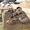
Misfire from a pottery kiln in the camp village that was uncovered in 2004
In Vicus Schloßau bullet bullets found and sling stones brownstone
Finds from the vicus


Limes course between the castles Schloßau and Oberscheidental
At Schloßau, the Limes fundamentally changes its course and structure. If it had adapted to the topographical conditions of the Odenwald Limes north of the place and had last run in a south-easterly direction (from the small fort Zwing to Schloßau), it now bends sharply in an almost southerly direction and keeps the following 35 kilometers - in dead straight, the Course that does not take into account the topography of the landscape - this orientation. In so doing, he anticipated the later construction of the Vorderen Limes . As far as Oberscheidental, the next fort village, it runs over a plateau with only slight differences in altitude and only drops by a total of around ten meters. On this path, which is now partly wooded and partly used for agriculture, it passes four more tower points, three of which are only suspected. This can be caused by the destruction of the tower parts by plowing over, but it can also be due to the fact that the course of the Limes can be assumed to be further east than had long been assumed.
| ORL | Name / place | Description / condition |
| ORL 51 | Castle Schlossau | see above |
| Wp 10/39 / | "Im Striet" | Due to the nature of the terrain, suspected but not archaeologically proven tower site. |
| Wp 10/40 | "Am Galmbacher Weg" | On the basis of older rock finds suspected but not archaeologically verifiable tower site. Possibly gone. |
| Wp 10/41 | "In the Heunenhaus" | Already at the time of the Reich Limes Commission no longer verifiable tower site. Gone by stone robbery. |
| Wp 10/42 | "In the Säubaumack" |
Tower site with at least one wooden tower and one stone tower.
By William Conrady a square stone tower with a side length of 5.60 m was detected 1,883th Karl Zangemeister reported on finely crafted cornice pieces in this context. Finally, aerial photographs from the 20th century show the dark discoloration of the moat of a wooden tower. |
| ORL 52 | Fort Oberscheidental | see main article Kastell Oberscheidental |

Monument protection
The castle of Schloßau and the mentioned ground monuments are protected as cultural monuments according to the Monument Protection Act of the State of Baden-Württemberg (DSchG) . Investigations and targeted collection of finds are subject to approval, and accidental finds are reported to the monument authorities.
See also
literature
- Dietwulf Baatz : The Roman Limes. Archaeological excursions between the Rhine and the Danube. 4th edition. Gebrüder Mann, Berlin 2000, ISBN 3-7861-2347-0 .
- Ernst Fabricius , Felix Hettner , Oscar von Sarwey (ed.): The Upper Germanic-Raetian Limes of the Roemerreiches , Department A, Volume 5: Route 10 (The Odenwald Limes from Wörth am Main to Wimpfen am Neckar). Petters, Berlin and Leipzig, 1926 and 1935, pp. 94–96 and plate 12, fig. 1.
- Britta Rabold: Civil settlement of the Roman numerus fort in Schloßau . In Dieter Planck (ed.): The Romans in Baden-Württemberg . Theiss, Stuttgart 2005, ISBN 3-8062-1555-3 , pp. 212-214.
- Britta Rabold: A new Roman brick factory and pottery on the Odenwald Limes in Mudau-Schlossau, Neckar-Odenwald district. In: Archaeological excavations in Baden-Württemberg 2003, Theiss, Stuttgart 2004, pp. 103-107.
- Britta Rabold: The Odenwald Limes in a new light. Research status 2005 on the fort vicus of Mudau-Schloßau . In: Gabriele Seitz (Ed.): In the service of Rome. Festschrift for Hans Ulrich Nuber . Greiner, Remshalden 2006, ISBN 3-935383-49-5 , pp. 279-284.
- Britta Rabold: Five years of archaeological excavations in Mudau-Schloßau, Neckar-Odenwald district . In: Archaeological excavations in Baden-Württemberg 2007 (2008), pp. 105ff.
- Britta Rabold: New research on the middle Odenwald Limes. Eight years of excavations in the fort vicus of Schloßau . In: Egon Schallmayer (Ed.): The Odenwald Limes. Latest research results. Contributions to the scientific colloquium on March 19, 2010 in Michelstadt . Saalburg Schriften 8, Bad Homburg 2012, ISBN 978-3-931267-07-0 , pp. 49-62.
- Egon Schallmayer : The Odenwald Limes. Along the Roman border between the Main and Neckar. Theiss, Stuttgart 2010, ISBN 978-3-8062-2309-5 , pp. 115-121.
- Karl Schumacher in The Upper Germanic-Raetian Limes of the Roemerreiches (Eds. Ernst Fabricius , Felix Hettner , Oscar von Sarwey ): Department B, Volume 5, Fort No. 51 (1900)
- Bruno Trunk: Roman traces in Schloßau and the surrounding area . Odenwälder, Buchen 2007, ISBN 978-3-936866-17-9 .
Web links
- Archaeological excavations 2004 ( Memento from March 14, 2007 in the Internet Archive ) in the online edition of the Fränkische Nachrichten
- Archaeological excavations 2005 ( Memento from March 14, 2007 in the Internet Archive ) in the online edition of the Fränkische Nachrichten
Individual evidence
- ↑ Egon Schallmayer: The Odenwald Limes. Along the Roman border between the Main and Neckar. Theiss, Stuttgart 2010, ISBN 978-3-8062-2309-5 . Pp. 26-27.
- ↑ Egon Schallmayer: The Odenwald Limes. Along the Roman border between the Main and Neckar. Theiss, Stuttgart 2010, ISBN 978-3-8062-2309-5 . P. 115 (drawing), 118.
- ↑ Egon Schallmayer: The Odenwald Limes. Along the Roman border between the Main and Neckar. Theiss, Stuttgart 2010, ISBN 978-3-8062-2309-5 . P. 115.
- ↑ Egon Schallmayer: The Odenwald Limes. Along the Roman border between the Main and Neckar. Theiss, Stuttgart 2010, ISBN 978-3-8062-2309-5 . P. 15.
- ↑ Britta Rabold: The Odenwald Limes in a new light. Research status 2005 on the fort vicus of Mudau-Schloßau . In: Gabriele Seitz (Ed.): In the service of Rome. Festschrift for Hans Ulrich Nuber . Greiner, Remshalden 2006, ISBN 3-935383-49-5 , pp. 279-284.
- ^ Britta Rabold: Five years of archaeological excavations in Mudau-Schloßau, Neckar-Odenwald district . In: Archaeological excavations in Baden-Württemberg 2007 (2008), pp. 105ff.
- ^ A b Egon Schallmayer: The Odenwald Limes. Along the Roman border between the Main and Neckar. Theiss, Stuttgart 2010, ISBN 978-3-8062-2309-5 . P. 116.
- ↑ Egon Schallmayer: The Odenwald Limes. From the Main to the Neckar. Konrad Theiß Verlag, Stuttgart 1984. ISBN 3-8062-0328-8 . P. 107.
- ↑ CIL 13, 06504
- ↑ Egon Schallmayer: The Odenwald Limes. Along the Roman border between the Main and Neckar. Theiss, Stuttgart 2010, ISBN 978-3-8062-2309-5 . Pp. 25-28.
- ^ Britta Rabold: A new Roman brickworks and pottery on the Odenwald Limes in Mudau-Schlossau, Neckar-Odenwald district. In: Archaeological excavations in Baden-Württemberg 2003, Theiss, Stuttgart 2004, pp. 103-107; here: p. 104.
- ^ Britta Rabold: A new Roman brickworks and pottery on the Odenwald Limes in Mudau-Schlossau, Neckar-Odenwald district. In: Archaeological excavations in Baden-Württemberg 2003, Theiss, Stuttgart 2004, pp. 103-107; here: p. 105.
- ↑ Egon Schallmayer: The Odenwald Limes. Along the Roman border between the Main and Neckar. Theiss, Stuttgart 2010, ISBN 978-3-8062-2309-5 . Pp. 116-118.
- ^ Britta Rabold: A new Roman brickworks and pottery on the Odenwald Limes in Mudau-Schlossau, Neckar-Odenwald district. In: Archaeological excavations in Baden-Württemberg 2003, Theiss, Stuttgart 2004, pp. 103-107; here: p. 106.
- ^ Britta Rabold: Civil settlement of the Roman numerus fort in Schloßau. In Dieter Planck (ed.): The Romans in Baden-Württemberg. Theiss, Stuttgart 2005, ISBN 3-8062-1555-3 , pp. 212-214.
- ^ Britta Rabold: A new Roman brickworks and pottery on the Odenwald Limes in Mudau-Schlossau, Neckar-Odenwald district. In: Archaeological excavations in Baden-Württemberg 2003, Theiss, Stuttgart 2004, pp. 103-107; here: p. 107.
- ↑ ORL A 5, section 10, p. 94ff.
- ↑ Egon Schallmayer: The Odenwald Limes. Along the Roman border between the Main and Neckar. Theiss, Stuttgart 2010, ISBN 978-3-8062-2309-5 , p. 119.
- ↑ a b c d Egon Schallmayer: The Odenwald Limes. Along the Roman border between the Main and Neckar. Theiss, Stuttgart 2010, ISBN 978-3-8062-2309-5 , p. 120.
- ↑ ORL A 5, p. 95.
- ↑ ORL A 5, pp. 95f.
Remarks
- ↑ The conventional starting date of the year 100 (± 5) is based on the results of the excavations that Dietwulf Baatz carried out in the Hesselbach fort between 1964 and 1966 . It is essentially based on the evaluation of the sigillates found (cf. the corresponding section in the Hesselbach article and Dietwulf Baatz: Fort Hesselbach and other research on the Odenwald Limes. Gebr. Mann, Berlin 1973, ISBN 3-7861-1059-X , ( Limesforschungen, Volume 12), pp. 85-96). In more recent literature, an initial dating of the Hesselbach fort and the entire Odenwald Limes to the period 107/110 is given preference. This dating approach is not based on new excavation findings, but on a statistical reassessment of the coin finds from all forts of the Upper Germanic-Raetian Limes, which the archaeologist Klaus Kortüm presented for the first time in 1998 and on which some authors of the more recent literature now rely. (cf. Klaus Kortüm: On the dating of the Roman military installations in the Upper German-Raetian Limes area . In: Saalburg-Jahrbuch 49, 1998. Zabern, Mainz 1998, pp. 5–65 and Egon Schallmayer : Der Limes. History of a border . Beck, Munich 2006, ISBN 3-406-48018-7 , pp. 49–52 and pp. 54f.)
- ↑ ORL = numbering of the Limes structures according to the publication of the Reich Limes Commission on the O bergermanisch- R ätischen- L imes
- ↑ ORL XY = consecutive numbering of the forts of the ORL
- ↑ Wp = W oh p east, watch tower. The number before the slash denotes the Limes section, the number after the slash denotes the respective watchtower.