
Small fort Robern
| Small fort Robern (Hönehaus, Hönenhaus, Wp 10/48) |
|
|---|---|
| limes | ORL NN ( RLK ) |
| Route (RLK) | ORL route 10 Neckar-Odenwald-Limes Odenwald line |
| Dating (occupancy) |
trajanic up to max. 159 |
| Type | Small fort |
| unit | unknown vexillatio |
| size | 20 × 21 m = 0.04 ha |
| Construction | Stone fort |
| State of preservation | preserved |
| place | Fahrbach |
| Geographical location | 49 ° 27 '57 " N , 9 ° 9' 37" E |
| height | 442 m above sea level NHN |
| Previous | ORL 52 Oberscheidental Castle (north) |
| Subsequently | Small fort Trienz (south) |
The small fort Robern , which is also known under the name Hönehaus or Hönenhaus , was a Roman border fort on the older Odenwald line of the Neckar-Odenwald-Limes in the area of the municipality of Fahrenbach in the Neckar-Odenwald district in Baden .
Location and research history


Today's ground monument is located in the “Kapellenwald” between the Limbach district of Wagenschwend and the Fahrenbach district of Robern. It is there at the base of a relatively steep slope, in an area where it flattens out a little.
In older literature and popularly, the small fort is also called Hönehaus or Hönenhaus , but must not be confused with the Hönehaus small fort of the same name on the Younger Odenwald line of the Upper German-Raetian Limes . In the local folklore, the former Roman garrison played a certain role in some legends.
After the fort had suffered some loss of substance in the Middle Ages and in modern times due to the fact that it served as a cheap quarry for Robern and Wagenschwend, it was archaeologically examined and archaeologically examined by the Reich Limes Commission under the direction of the responsible route commissioner Karl Schumacher documented.
Today the foundation walls of the fort have been preserved and are open to the public.
Findings
The excavations carried out by the commission uncovered a fortification of just 400 square meters, which had previously been mistaken for a watchtower (Wp 10/48). However, it was a two-gate stone fort with a slightly shifted square floor plan with a side length of 20 m. The stone fence had strongly rounded corners and was made entirely of red sandstone. The thickness of the rising masonry, which rested on a foundation made of smaller chunks of sandstone, was 95 cm to 104 cm. At the foot of the riser there was a 14 cm to 18 cm high, beveled protruding base belt. Originally the wall was covered with white mortar plaster with painted red false joints.
The main entrance of the two-gate complex was towards the Limes, on the east side of the fort. It was 2.96 m wide and flanked by 91 cm to 98 cm thick, retracted gate cheeks. A three-meter-wide path with stone embroidery led out of the gate, which crossed the five-meter-wide Limes accompanying path and led to a spring. The second gate on the westward facing Dekumatseite (rear side) of the camp consisted of a simple, only 1.71 m wide passage. There was no weir.
There were no stone buildings inside the fortification, but only half-timbered buildings, as evidenced by the pieces of clay found. Nothing is known about the crew, presumably the vexillatio of a larger auxiliary unit . Some cornice and lid stones as well as a relief of Victoria come from the fort .
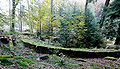
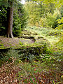
- Small fort Robern (state October 2009)
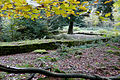
North side
Northwest corner
East wall with main entrance

Southern part of the western wall from the Porta Decumana (in the foreground)


Limes course between the small forts Robern and Trienz
From the small fort Robern, the Limes runs linearly in a southerly direction. Here it first climbs 20 meters in altitude up to Wp 10/49, and then drops 75 meters to the small fort Trienz. On his way he leaves the forest not far from the Robener fortification, passes the agricultural land surrounding the village of Robern and the village itself and leads south of the village through another, narrow forest before reaching the former garrison of Trienz.
| ORL | Name / place | Description / condition |
|---|---|---|
| Wp 10/48 = KK | Small fort Robern | see above |
| Wp 10/49 | "In the old field" | Due to stone robbery in 1862 and road construction work between 1872 and 1874, the tower was completely lost before the activities of the Reich Limes Commission began |
| Wp 10/50 | "Brenneisenäcker" | Based on the average distances between Limes watchtowers and the topographical conditions, a suspected but not archaeologically proven tower site |
| Wp 10/51 | "On the Roberner Höhe" |
Place of a stone tower, which was partially stolen before the commission's activities in the 1870s. A more detailed investigation was not carried out, there are no even halfway meaningful measurements. Only a cornice and a base stone, which come from the findings , are secured.
The location of the tower was well chosen, from here the line of sight extended in the north to the watchtower Wp 10/46 and in the south via the small fort Trienz and the Wp 10/53 to the towers at Sattelbach . The Roman road that runs up to this point in the Limes flight turns here in a south-westerly direction. The RLK was able to measure the route in this area with a width of around 4.90 m. |
| Wp 10/52 = KK | Small fort Trienz |
|

Monument protection
The small fort Robern and the mentioned ground monuments are protected as cultural monuments according to the Monument Protection Act of the State of Baden-Württemberg (DSchG) . Investigations and targeted collection of finds are subject to approval, and accidental finds are reported to the monument authorities.
See also
literature
- Dietwulf Baatz : The Roman Limes. Archaeological excursions between the Rhine and the Danube . 4th edition, Gebr. Mann, Berlin 2000, ISBN 3-7861-2347-0 , pp. 201f.
- Ernst Fabricius , Felix Hettner , Oscar von Sarwey (eds.): The Upper Germanic-Raetian Limes of the Roemerreiches , Department A, Volume 5: Route 10 (The Odenwald Limes from Wörth am Main to Wimpfen am Neckar), 1926, 1935, p. 102 –104 as well as panel 12, fig. 4 and panel 13, fig. 1
- Christian Fleer: Typification and function of the small buildings on the Limes. In: Egon Schallmayer (Ed.): Limes Imperii Romani. Contributions to the specialist colloquium “Limes World Heritage Site” in November 2001 in Lich-Arnsburg. Bad Homburg vdH 2004, ISBN 3-931267-05-9 , (= Saalburg-Schriften, 6) pp. 75–92.
- Hans Kröninger The Odenwald-Limes and the small fort Hönehaus near Robern. In: Heimatbuch Robern, Rhein-Neckar-Zeitung, 2007, p. 39 ff. (= Unser Land , 2007, p. 107–110)
- Egon Schallmayer : The Odenwald Limes. Along the Roman border between the Main and Neckar. Theiss, Stuttgart 2010, ISBN 978-3-8062-2309-5 , pp. 125-128.
- Egon Schallmayer (Ed.): The Odenwald Limes. Latest research results. Contributions to the scientific colloquium on March 19, 2010 in Michelstadt . Saalburgmuseum, Bad Homburg 2012, ISBN 978-3-931267-07-0 (Saalburg-Schriften, 8).
- Andreas Thiel : Odenwald Limes in the Neckar-Odenwald district . In: Dieter Planck (Ed.): The Romans in Baden-Württemberg . Theiss, Stuttgart, 2005, ISBN 3-8062-1555-3 , pp. 191f.
Web links
- Small fort Hönehaus on the private Limes project page of Claus te Vehne
Remarks
- ↑ The conventional starting date of the year 100 (± 5) is based on the results of the excavations that Dietwulf Baatz carried out in the Hesselbach fort between 1964 and 1966 . It is essentially based on the evaluation of the sigillates found (compare the corresponding section in the Hesselbach article and Dietwulf Baatz: Fort Hesselbach and other research on the Odenwald Limes . Gebr. Mann, Berlin 1973, ISBN 3-7861-1059-X , (Limesforschungen , Volume 12), pp. 85-96). In more recent literature, an initial dating of the Hesselbach fort and the entire Odenwald Limes to the period 107/110 is given preference. This dating approach is not based on new excavation findings, but on a statistical reassessment of the coin finds from all forts of the Upper Germanic-Raetian Limes, which the archaeologist Klaus Kortüm presented for the first time in 1998 and on which some authors of the more recent literature now rely. (cf. Klaus Kortüm: On the dating of the Roman military installations in the Upper German-Raetian Limes area . In: Saalburg-Jahrbuch 49, 1998. Zabern, Mainz 1998, pp. 5–65 and Egon Schallmayer : Der Limes. History of a border . Beck, Munich 2006, ISBN 3-406-48018-7 , pp. 49–52 and pp. 54f.)
- ↑ Stone embroidery is the planned setting of unprocessed rubble stones to consolidate the level of a path.
- ↑ ORL = numbering of the Limes structures according to the publication of the Reich Limes Commission on the O bergermanisch- R ätischen- L imes
- ↑ KK = unnumbered K linseed K astell.
- ↑ Egon Schallmayer: The Odenwald Limes. Along the Roman border between the Main and Neckar. Theiss, Stuttgart 2010, ISBN 978-3-8062-2309-5 , p. 127.
- ^ A b Egon Schallmayer: The Odenwald Limes. Along the Roman border between the Main and Neckar. Theiss, Stuttgart 2010, ISBN 978-3-8062-2309-5 , p. 128.
- ↑ 49 ° 26 '26 " N , 9 ° 9' 51" E