
Hainhaus Castle
| Hainhaus Fort (Vielbrunn Fort) |
|
|---|---|
| limes | ORL 47 ( RLK ) |
| Route (RLK) | ORL route 10 Neckar-Odenwald-Limes Odenwald line |
| Dating (occupancy) |
trajanic up to max. 159 ad |
| Type | Numerus fort |
| unit | unknown number |
| size | 72 × 79 m = 0.57 ha |
| Construction | c) wood-earth (presumably) b) dry stone wall c) mortar-stone wall |
| State of preservation | clear traces |
| place | Michelstadt - Vielbrunn |
| Geographical location | 49 ° 43 '58 " N , 9 ° 4' 59.5" E |
| height | 457 m above sea level NHN |
| Previous | Small fort Windlücke (north) |
| Subsequently | ORL 48 Fort Eulbach (south) |
The Roman fort Hainhaus , also described in the literature as Fort Vielbrunn , was a numerus fort of the older Odenwald line of the Neckar-Odenwald-Limes . Today's ground monument is located in a wooded area around two and a half kilometers NNE from the center of Vielbrunn , a district of Michelstadt in southern Hesse .
location


The almost 5700 m² of the fort area extend on the plateau of a ridge between the Kimbachtal in the west and the Ohrbach valley in the east. The terrain slopes slightly from east to west, and slightly more steeply from south to north. In ancient times, the fortification at this point probably had the task of monitoring the transition between the two valleys. Today the villages of Vielbrunn and Kimbach, a district of Bad König , are located in the valleys, and their modern connecting road runs about two kilometers south of the fort.
Research history
The fort square was also known in post-Roman times and was visible as a ruin. In a document from 1432 it is referred to as Bentzenburg , which means something like "Geisterburg". In the 18th century the princes of Löwenstein-Wertheim-Rosenberg built a hunting lodge in the middle of the fort area. In the investigations carried out by Johann Friedrich Knapp on behalf of Count Franz I. zu Erbach-Erbach in 1806, the actual fortification was neglected, as it was believed that this had already been severely damaged by the construction of the hunting lodge, and instead focused primarily on the Fort thermal baths . The only scientific archaeological excavations of the fort itself so far were only carried out in 1895 by the Reichs-Limeskommission (RLK) under the local excavation management of the route commissioner Friedrich Kofler , who also re-examined the fort bath.
Findings
Fort

Beyond the recent mortar stone walls, at least remnants of dry stone walls could be found, which suggests that this military camp - as demonstrated for the nearby forts of Würzberg and Hesselbach - went through all three construction phases of the older Odenwald Limes. So would be
- the Hainhaus fort was built in the Trajan period using a wood-earth construction method,
- In Hadrianic time , i.e. between 117 and 138, a double dry wall filled with earth in the space in between replaced the wooden enclosure ,
- between 140 and 150 the dry masonry was replaced by a mortar stone wall.
If the Limes were moved forward by around 30 km in an easterly direction, the fort would have been abandoned - like the entire Odenwald Limes - by 159/160 at the latest.
The fortification of Vielbrunn covered an area of almost 0.6 hectares in the form of a slightly irregular square. With its praetorial front, it faced east, towards the Limes, which passed the camp about 80 meters away. The length of the front was 70.95 m, that of the rear 72.52 m. The north side wall was 78.47 m long, the south 79.20 m long. The corners of the approximately 80 cm thick wall were rounded and not provided with defensive towers. After a 0.75 m to 1.20 m wide berm , a simple, between 6.40 m and 7.70 m wide and between 1.40 m and 1.90 m deep pointed trench in the form of a so-called point served as an obstacle to approach Fossa Punica , the slope of which, facing away from the fort, fell significantly more steeply than that facing the defensive wall.
The camp had three gates, each flanked by two towers, and - at least in one construction phase - a small rear hatch . On the inside of the wall, a four to five meter wide earth wall was built up, to which in turn the 2.80 to 3.50 m wide Wallweg connected. At the time of the excavations, traces of the actual interior structures of the camp had already been completely destroyed by the modern building measures, only the axes of the path could be identified through a few excavation cuts.
The crew of the camp made an about 150 men strong, including unknown number .

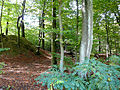
Decumate side of the fence

Praetorial side of the fence
Modern ice cellar (left) and Roman fortifications (right)
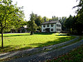
Main building of the modern hunting lodge


Fort bath
The fort thermal baths , which had already been examined by Knapp, were located 180 m north-west of the camp . It is a row type bathroom. The longitudinal axis of the building - including the praefurnium (boiler room) - was 18.5 m, the maximum width of the building complex was 11.13 m. From the southeast side one entered a room which Kofler interpreted as an apodyterium (changing room). Similar to other military baths, however, it must be assumed that the room functioned as a frigidarium . The actual apodyterium , presumably in the form of a vestibule made of wood, could probably not be perceived with the excavation methods of the time. On the left side of this room there was a cold water basin in an annex building, on the right another, hypocausted annex building with a separate praefurnium, which must be addressed as a sudatorium . The tepidarium (leaf bath) was located in the middle of the building . With a three- room caldarium (warm bath), which was completely provided with hypocausts, and the associated boiler room, the building complex closed off in the northwest.
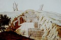
Thermal baths around 1806

Floor plan of the fort thermal baths
(excavation 1895)
Sections through the fort thermal baths


State of preservation and found material
The fort defenses stand out clearly in the area, but there are hardly any traces of the bathing building. The six stone armchairs at the height of the Porta praetoria belong to the 18th century and thus belong to the hunting lodge. This also applies to a hill-shaped elevation in the area of the south-western corner of the fort, which is a modern ice cellar. A tour of the area is possible at any time. In Michelstadt, the region's Roman past is presented in a small section of the Odenwald Museum.
- Findings from the excavations in 1895 in the Hainhaus fort
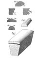
Corner, cornice and cap stones

Above: Wall tile with a round recess for the fastening
nail Below: Clay funnel for fastening heated tiles
Above: Edge piece of a Terra Nigra vessel
Middle: Brick
stamp Below: Brick plate


Limes course between the forts Hainhaus and Eulbach
From the Hainhaus fort, the Limes continues - exclusively through the forest and the edge of the forest - towards the Eulbach fort. Here it rises gradually from 457 to 510 meters.
| ORL | Name / place | Description / condition | ||||||
|---|---|---|---|---|---|---|---|---|
| ORL 47 | Hainhaus Castle | see above | ||||||
| Wp 10/14 / | "On the Döllchen Lane" | The stone tower no longer existed at the time of the Reich Limes Commission. It probably served as a cheap quarry when building roads or building the hunting lodge.
The location of the former wooden tower is clearly visible in the area through the ring ditch that surrounds it, in which there is occasional water depending on the season and weather. In this area, the commission measured the surface structures, but no archaeological investigation was carried out.
|
||||||
| Wp 10/15 | "In the upper reel" | The stone tower of the tower site Wp 10/15 probably fell victim to road construction work in this area early on, where its rubble was used as curb stones.
The surface structure of the wooden tower, which is cut about halfway from the modern road, was measured by the commission, but not archaeologically examined. Weak, partly boggy traces of the moat and the tower hill can be found immediately west of the road in a group of bushes. There is a stone foundation in the tower hill, but it is modern and has no connection with the ancient buildings. The wooden tower was reconstructed a few meters north in 2010. The reconstruction is largely identical to that of Rainau-Buch (Wp 12/77 “Mahdholz”) .
|
||||||
| Wp 10/16 | "At Vielbrunn" | The tower was largely destroyed by agriculture in the 19th century and could only be localized by the Imperial Limes Commission on the basis of the higher stone concentration there. For a long time it was considered "completely lost". Using modern geophysical prospecting methods , however, it was possible in 2009 to localize the tower and part of the Limes accompanying path | ||||||
| Wp 10/17 | "In the hay mats" |
The well-preserved wooden tower hill was only measured in terms of its surface structure by the Imperial Limes Commission, but not archaeologically examined.
About 40 m south of the wooden tower there was at least one stone tower, which, however, had already been exploited and destroyed as a quarry for the purpose of road construction at the time of the Reich Limes Commission.
|
||||||
| Wp 10/18 | "In the barons' forest" |
Very well preserved wooden tower, which including the wall-like elevation on the outside of the ring ditch surrounding it must have had a diameter of over 30 m. The Reichs-Limeskommission only carried out a height leveling, an archaeological excavation was dispensed with.
The stone tower belonging to the tower site was - like most of the others in this section of the route - destroyed before the commission started working for the purpose of using the stone material in road construction. |
||||||
| Wp 10/19 | "At the Lichten Platte" |
The tower of the watchtower Wp 10/19, which is still visible in the area today, is - like the following Wp 10/20 - not accessible to the public within the grounds of the Graeflich Erbachischen Eulbacher Wildpark. It is the usual place in a wooden tower surrounded by a moat with a tower hill in the center. However, the contours are a little disturbed by the temporary overbuilding with a game shed. An archaeological investigation resp. detailed measurement was not carried out.
The stone tower ruins were about 35 m away, but were demolished in 1842 when the road from Eulbach to Vielbrunn was built. A scheduled archaeological investigation did not take place, however fragments of the original building inscription were recovered during the demolition work. According to this, the tower was built in 146 AD by a unit of the Triputian Brittons. The original size of the inscription plate was 58 cm by 80 cm with a thickness of about 15 cm. The fragments are now in the Count's collections at Erbach Castle .
|
||||||
| Wp 10/20 | "On the Kutschenweg" |
Tower site, consisting of a wooden tower hill and a completely worn stone tower.
The wooden tower hill, which the Limes palisade passed at a distance of 27 m to the east, was examined by Eduard Anthes in 1896 . The wooden tower rested on a foundation made of dry masonry, which had a square floor plan with a side length of 5.20 m and was still up to a height of 80 cm in Anthe's time. At the corners there were 35 cm² recesses to accommodate the corner posts, which were sunk 1.30 m into the depth. The walls had three slits 10 cm to 25 cm wide on each side. The interior of the drywall rectangle was probably filled with earth and clay. The tower was surrounded by a moat with a diameter of 15 m. The profile of the trench was not determined. About 20 m south of the wooden tower was the stone tower, which had already been completely destroyed by the time of the Reich Limes Commission. The tower location Wp 10/20 is located in a part of the Graeflich Erbach-Erbach'schen wildlife park that is not open to the public. |
||||||
| ORL 48 | Fort Eulbach |


_2012-09-28_02.jpg)
_2012-09-28_46.jpg)
_2012-09-28_04.jpg)

_2012-09-28_10.jpg)
_2012-09-28_12.jpg)
_2012-09-28_20.jpg)


Monument protection
The Hainhaus fort and the adjacent Limes structures are ground monuments according to the Hessian Monument Protection Act . Investigations and targeted collection of finds are subject to approval, and accidental finds are reported to the monument authorities.
See also
literature
- Dietwulf Baatz : Michelstadt-Vielbrunn . In: The Romans in Hesse . Licensed edition of the 1982 edition. Nikol, Hamburg 2002, ISBN 3-933203-58-9 , p. 436ff.
- Dietwulf Baatz: The Roman Limes. Archaeological excursions between the Rhine and the Danube . Gebr. Mann, Berlin 2000, ISBN 3-7861-2347-0 , pp. 184f.
- Ernst Fabricius , Felix Hettner , Oscar von Sarwey (eds.): The Upper Germanic-Raetian Limes of the Roemerreiches , Department A, Volume 5: Route 10 (The Odenwald Limes from Wörth am Main to Wimpfen am Neckar), 1926, 1935.
- Margot Klee : The Roman Limes in Hessen. History and sites of the UNESCO World Heritage. Verlag Friedrich Pustet, Regensburg 2009, ISBN 978-3-7917-2232-0 , pp. 188f.
- Friedrich Kofler in: The Upper Germanic-Raetian Limes of the Roemerreiches (Eds. Ernst Fabricius, Felix Hettner, Oscar von Sarwey): Department B, Volume 5, Fort No. 47 (1897).
- Egon Schallmayer : The Odenwald Limes. Along the Roman border between the Main and Neckar. Theiss, Stuttgart 2010, ISBN 978-3-8062-2309-5 , pp. 85-90.
- Egon Schallmayer: The Odenwald Limes. Latest research results. Contributions to the scientific colloquium on March 19, 2010 in Michelstadt . Saalburg Museum, Bad Homburg 2012, ISBN 978-3-931267-07-0 (Saalburg-Schriften, 8)
Web links
- Sights in the Odenwald ( Memento from October 12, 2007 in the Internet Archive ) on the old website of the Odenwald Regional Society (OREG) - since September 19, 2012.
- Fort Hainhaus on the private Limes project site of Claus te Vehne
Individual evidence
- ↑ a b The conventional starting date of the year 100 (± 5) is based on the results of the excavations that Dietwulf Baatz carried out in the Hesselbach fort between 1964 and 1966 . It is essentially based on the evaluation of the sigillates found (cf. the corresponding section in the Hesselbach article and Dietwulf Baatz: Fort Hesselbach and other research on the Odenwald Limes. Gebr. Mann, Berlin 1973, ISBN 3-7861-1059-X , ( Limesforschungen, Volume 12), pp. 85-96). In more recent literature, an initial dating of the Hesselbach fort and the entire Odenwald Limes to the period 107/110 is given preference. This dating approach is not based on new excavation findings, but on a statistical reassessment of the coin finds from all forts of the Upper Germanic-Raetian Limes, which the archaeologist Klaus Kortüm presented for the first time in 1998 and on which some authors of the more recent literature now rely. (cf. Klaus Kortüm: On the dating of the Roman military installations in the Upper German-Raetian Limes area . In: Saalburg-Jahrbuch 49, 1998. Zabern, Mainz 1998, pp. 5–65 and Egon Schallmayer : Der Limes. History of a border . Beck, Munich 2006, ISBN 3-406-48018-7 , pp. 49–52 and pp. 54f.)
- ↑ a b Rainer Türk: Hikes on the Limes . Brunnengräber, Lorsch 2008, ISBN 978-3-9811444-1-3 , pp. 30–34.
- ^ Johann Friedrich Knapp: Roman monuments of the Odenwald, in particular of the county of Erbach and the rule of Breuberg . Engelmann, Heidelberg 1813; Meder, Heidelberg 1814²; Jonghaus, Darmstadt 1854³.
- ^ A b After Dietwulf Baatz : Fort Hesselbach and other research on the Odenwald Limes. Gebr. Mann, Berlin 1973, ISBN 3-7861-1059-X , (Limes Research Volume 12).
- ↑ Egon Schallmayer: The Odenwald Limes. Along the Roman border between the Main and Neckar. Theiss, Stuttgart 2010, ISBN 978-3-8062-2309-5 , pp. 85f.
- ^ Compare Britta Rabold: Walldürn. Numerus fort, civil settlement and bath . In: Dieter Planck (Ed.): The Romans in Baden-Württemberg . Theiss, Stuttgart 2005, ISBN 3-8062-1555-3 , pp. 358ff.
- ↑ Compare Christoph Unz: Grinario. The Roman fort and village in Köngen . Theiss, Stuttgart 1982, ISBN 3-8062-0302-4 , (Guide to archaeological monuments in Baden-Württemberg, 8), p. 69.
- ↑ Egon Schallmayer: The Odenwald Limes. Along the Roman border between the Main and Neckar. Theiss, Stuttgart 2010, ISBN 978-3-8062-2309-5 , p. 86.
- ↑ Odenwald and Toy Museum Michelstadt ( Memento of the original from December 27, 2015 in the Internet Archive ) Info: The archive link has been inserted automatically and has not yet been checked. Please check the original and archive link according to the instructions and then remove this notice. .
- ^ A b Egon Schallmayer: The Odenwald Limes. Along the Roman border between the Main and Neckar. Theiss, Stuttgart 2010, ISBN 978-3-8062-2309-5 , p. 87.
- ↑ The short distance to the next tower point is probably due to the securing of an old pass path from the Main into the Mümlingtal to today's Bad König .
- ↑ Dietwulf Baatz: The watchtowers on the Limes. Aalener Schriften 15, Stuttgart 1976; Günter Ulbert , Thomas Fischer: The Limes in Bavaria . Konrad Theiss Verlag, Stuttgart 1983, ISBN 3-8062-0351-2 . P. 38
- ↑ “ Archaeologists come across the remains of a Roman tower ( page no longer available , search in web archives ) Info: The link was automatically marked as defective. Please check the link according to the instructions and then remove this notice. " In" Echo-Online ", edition of December 9, 2009, accessed on December 9, 2009
- ↑ Egon Schallmayer: The Odenwald Limes. Along the Roman border between the Main and Neckar. Theiss, Stuttgart 2010, ISBN 978-3-8062-2309-5 , pp. 87f.
- ^ A b Egon Schallmayer: The Odenwald Limes. Along the Roman border between the Main and Neckar. Theiss, Stuttgart 2010, ISBN 978-3-8062-2309-5 , p. 88.
- ↑ CIL 13, 6518
- ↑ Egon Schallmayer: The Odenwald Limes. Along the Roman border between the Main and Neckar. Theiss, Stuttgart 2010, ISBN 978-3-8062-2309-5 , pp. 89f.
- ↑ Egon Schallmayer: The Odenwald Limes. Along the Roman border between the Main and Neckar. Theiss, Stuttgart 2010, ISBN 978-3-8062-2309-5 , p. 90.
Remarks
- ↑ Not to be confused with the previous literature also as a fort Hainhaus or fort Hainhäusel designated fort Würzberg , ORL 49, at Michel City Würzberg.
- ↑ ORL = numbering of the Limes structures according to the publication of the Reich Limes Commission on the O bergermanisch- R ätischen- L imes
- ↑ ORL XY = consecutive numbering of the forts of the ORL
- ↑ Wp = W oh p east, watch tower. The number before the slash denotes the Limes section, the number after the slash denotes the respective watchtower.
- ↑ Approximately at 49 ° 43 ′ 35 ″ N , 9 ° 5 ′ 6 ″ E
- ↑ Around 49 ° 43 '11 " N , 9 ° 5' 9.5" E
- ^ Wp 10/15 on the private Limes project page by Claus te Vehne
- ↑ Around 49 ° 42 ′ 49 ″ N , 9 ° 5 ′ 9 ″ E
- ↑ Approximately at 49 ° 42 '23 " N , 9 ° 5' 3" E
- ↑ Wp 10/17 th on the private Limes project page of Claus Vehne
- ↑ Around 49 ° 42 '8 " N , 9 ° 4' 58" E
- ^ Wp 10/18 on the private Limes project page by Claus te Vehne
- ↑ Around 49 ° 41 ′ 36 ″ N , 9 ° 5 ′ 0 ″ E
- ↑ Around 49 ° 41 ′ 16 ″ N , 9 ° 4 ′ 54 ″ E
- ↑ 49 ° 43 '58 " N , 9 ° 4' 59.5" E