
Fort Eulbach
| Fort Eulbach | |
|---|---|
| limes | ORL 48 ( RLK ) |
| Route (RLK) | ORL route 10 Neckar-Odenwald-Limes Odenwald line |
| Dating (occupancy) |
trajanic up to max. 159 ad |
| Type | Numerus fort |
| unit | unknown number |
| size | 70 × 78 m = 0.55 ha |
| Construction | a) Wood and earth fort. b) Stone fort |
| State of preservation | weak tracks |
| place | Michelstadt - Würzberg |
| Geographical location | 49 ° 40 ′ 48 " N , 9 ° 4 ′ 40.5" E |
| height | 510 m above sea level NHN |
| Previous | ORL 47 Hainhaus Fort (north) |
| Subsequently | ORL 49 Würzberg Fort (south) |
The Eulbach fort was a Roman numerus fort of the older Odenwald line of the Neckar-Odenwald-Limes . Today's ground monument is located in the corridor of the hamlet of Eulbach in the east of the urban area of Michelstadt in the Odenwaldkreis in Hesse .
location


The Eulbach fort is located in a wooded area between the Michelstadt districts of Vielbrunn and Würzberg . It is there to approximately 510 meters above sea level, on the ridge line a extending from north to south ridge . The federal road 47 , which connects Michelstadt with Amorbach and reaches its apex at this point , runs right through the ground monument . About 250 meters east of the fort, the state road L 3349 branches off from the B 47 to the north in the direction of Vielbrunn.
Assuming an unwooded foreland, the fort crew would have had an unobstructed view of the eastern and southeastern valleys up to the Main, all the more as the fort area was slightly inclined to the east and south.
The Eulbach Hunting Lodge and Eulbacher Park are located about 150 meters west of the former fort area .
Research history
After the Limes was moved forward around 159 and the associated abandonment of the camp, the Eulbach fort was still visible as a ruin for a long time. It is mentioned in a document at the beginning of the 9th and again in the 11th century. The village of Eulbach later emerged in this area, but it was destroyed during the Thirty Years' War . In 1806 the fort was rediscovered during agricultural work and examined and uncovered by Johann Friedrich Knapp on behalf of Count Franz I of Erbach-Erbach (1754–1823). At that time, one or two stone layers of the masonry were left. The fort bath was located in 1889. The scientific archaeological excavation carried out by the Reichs-Limeskommission (RLK) under the local excavation management of Friedrich Kofler in 1895 had already established that the fort area had been largely destroyed. The solid masonry had completely disappeared and the former shape of the camp only had to be reconstructed on the basis of the foundation trenches and some rubble.
Findings
With its praetorial front , the fort faced the east, facing the Limes, which was about 80 meters away. The length (outside) of the front was calculated at 71.13 meters, that of the rear front with 72.50 meters, the length of the left side flank was estimated at 79.90 meters, that of the right flank with 79.27 meters. This results in internal dimensions of around 70 × 78 meters, which corresponds to an area of around 5500 square meters. The thickness of the defensive wall was probably just under 1.10 meters, it was made of white sandstone. A total of three gates were found, the porta decumana (rear gate) was missing or, analogous to comparable Limes forts, was only designed in the form of a small slip gate and could not be determined with the excavation methods of the time. The Porta praetoria (main gate) was completely demolished at the beginning of the 19th century and reconstructed on the basis of Knapp's findings documentation in Eulbacher Park. In front of the defensive wall, following an approximately 75 centimeter wide berm , the camp was surrounded by a 6.00 to 7.50 meter wide and 1.50 to 1.60 meter deep trench, which was built in front of the Porta principalis dextra ( right side gate) and the Porta principalis sinistra (left side gate) were each interrupted by an earth dam.
On the inside of the camp, behind the defensive wall, there was a rampart about five meters wide that supported the battlement. The main streets of the camp, Via praetoria , Via decumana , Via principalis and Via muralis , were paved with stone embroidery and a covering of small stones and pebbles. Remnants of the walls of buildings could not be detected, but the frequency of broken bricks and the paving interpreted as floors suggest a formerly solid interior.
The Eulbach fort was probably used from the Trajan period up to the year 159 at the latest, and during this time it went through at least two construction phases from the wood and earth fort to the stone fort. The crew, not known by name, was probably a number , an auxiliary troop unit of around 160 men.
Lost property
Most of the building remains and other finds were already removed during the first excavations and brought to the immediately adjacent Eulbacher Park , which was created at the same time. There they were reconstructed less technically correct than in the style of the time or were used, together with other finds from Odenwald Limes forts, as spoils of landscape architecture and can still be viewed today. In addition, only faint traces can be traced in the area, especially since the fort area is crossed by federal road 47.
- Roman stone monuments in Eulbacher Park

Stone pillar

Viergötterstein
Inscription stone CIL XIII, 06502

Reconstructed Wp 10/22


.jpg)

Limes course between the forts Eulbach and Würzberg
The Limes continues south from Fort Eulbach, through woodland to the watchtower Wp 10/22. Immediately south of Wp 10/22 he leaves the wooded area and crosses the agricultural areas west of today's Würzberg, a small district of Michelstadt. Here it reaches out in a wide arc to the west. In total, it only rises slightly by around 15 meters in altitude in this section.
| ORL | Name / place | Description / condition |
|---|---|---|
| ORL 48 | Fort Eulbach | see above |
| Wp 10/21 | "In the hay mat" | Discovered by Friedrich Kofler in 1887, but not archaeologically examined, part of the tower with probably a stone and a wooden tower. The site is on a wet meadow in part of the Eulbach Wildlife Park.
|
| Wp 10/22 | "Am Vogelherdschlag" |
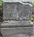
Tower site of a not yet examined wooden tower and a stone tower that had already been excavated in Knapp's time. It is about the stone tower, the rising masonry of which was completely removed and moved, together with the building inscription, to Eulbacher Park, where it was wrongly declared a tombstone. The building inscription reads:
] / [N (VMERVS) B] RITTO
[N] VM TRI [PV] T (IENSIVM) IMP (ERATORE) [A] NT (ONINO) IIII CO (N) S (ULE) Translated: ("Erected by the) number of the Brittones Triputienses, (when) Emperor Antoninus Pius (was) consul for the fourth time ." Accordingly, the tower would have been built in 145 by a number of the Brittones Triputienses . Originally it was a tower with a square floor plan, the side length of which was approximately 5.40 meters to 5.45 meters. The foundation walls were preserved on the spot, and the site was provided with a small parking lot. |
| Wp 10/23 | "At the height of 535.5" | Based on the average distances between Limes watchtowers and the topographical conditions, as well as the fact that this location is marked with "Roman Castle" in old land maps, assumed but not proven and / or archaeologically excavated tower location. |
| Wp 10/24 | "In the Würzberger Feld" | Suspected due to the average watchtower distances and the topography of the area, as well as due to the high occurrence of litter finds in this area, but not archaeologically proven. |
| Wp 10/25 | "On the Red Hump" | Tower site of a wooden and a stone tower in the edge of the forest on the Roten Buckel ( 540.2 m above sea level ). The tower site was only excavated archaeologically in 1975. The stone tower had a square floor plan with sides of 5.40 meters, its wall thickness was between 0.80 meters and 0.90 meters. The wall was designed as shell masonry with carefully worked facing shells and a core made of cast mortar with stone fragments. Heavy incineration debris indicates an end of the tower due to fire.
The wooden tower located around 12 meters north of the stone tower is a two-period structure that was surrounded by two ring ditches. The younger pointed ditch was sunk into the backfilling of the older fossa punica . The stone drywall foundations of the wooden towers were already badly damaged. A small number of animal bones were found at this watchtower, which provide information about the soldiers' nutrition. It was found that sheep and goats dominated, while pork and beef were consumed far less. This range of finds is not atypical for many military sites. The foundation walls of the stone tower have been preserved, the wooden tower can still be seen in the area through its ring moat. About 800 meters to the west is the eagle stone , which indicates the (forged) discovery of a Roman legionary eagle.
|
| ORL 49 | Würzberg Castle |
|


_2012-09-28_08.jpg)
_2012-09-28_6.jpg)


Monument protection
The small fort Windlücke and the adjacent Limes structures are ground monuments according to the Hessian Monument Protection Act . Investigations and targeted collection of finds are subject to approval, and accidental finds are reported to the monument authorities.
See also
literature
- Dietwulf Baatz : Michelstadt-Eulbach . In: The Romans in Hesse . Nikol, Hamburg 2002 (reprint of the 2nd edition 1989), ISBN 3-933203-58-9 , p. 432ff.
- Dietwulf Baatz: The Roman Limes. Archaeological excursions between the Rhine and the Danube . Gebr. Mann, Berlin 2000, ISBN 3-7861-2347-0 , pp. 185ff.
- Ernst Fabricius , Felix Hettner , Oscar von Sarwey (ed.): The Upper Germanic-Raetian Limes des Roemerreiches , Department A, Volume 5: Route 10 (The Odenwald Limes from Wörth am Main to Wimpfen am Neckar), 1926, 1935, pp. 51ff ., Panel 5 fig. 3, panel 15 fig. 2.
- Holger Göldner: The English Garden “Eulbacher Park”. Roman relics from the Odenwald Limes in a 19th century landscape garden near Michelstadt in the Odenwald district . State Office for Monument Preservation Hessen, Wiesbaden 2001, ISBN 3-89822-152-0 , ( Archaeological Monuments in Hessen , Issue 152).
- Margot Klee: The Roman Limes in Hessen. History and sites of the UNESCO World Heritage. Pustet, Regensburg 2009, ISBN 978-3-7917-2232-0 , pp. 190-192.
- Friedrich Kofler in: Ernst Fabricius , Felix Hettner , Oscar von Sarwey (ed.): The Upper Germanic-Raetian Limes of the Roemerreich . Department B, Volume 5, Fort No. 48, 1896.
- Egon Schallmayer : The Odenwald Limes. Along the Roman border between the Main and Neckar. Theiss, Stuttgart 2010, ISBN 978-3-8062-2309-5 , pp. 90-97.
- Egon Schallmayer: The Odenwald Limes. Latest research results. Contributions to the scientific colloquium on March 19, 2010 in Michelstadt . Saalburg Museum, Bad Homburg 2012, ISBN 978-3-931267-07-0 (Saalburg-Schriften, 8)
- Walter Weidmann : Eulbach. A home book . Stadt Michelstadt, Michelstadt 2002, ISBN 3-924583-39-0 , in particular pp. 14-19 and 140-154.
Web links
- The Eulbacher Park with its Roman relics on the private Limes project page of Claus te Vehne
Individual evidence
- ↑ Egon Schallmayer : The Odenwald Limes. Along the Roman border between the Main and Neckar. Theiss, Stuttgart 2010, ISBN 978-3-8062-2309-5 , p. 90.
- ↑ Egon Schallmayer: The Odenwald Limes. Along the Roman border between the Main and Neckar. Theiss, Stuttgart 2010, ISBN 978-3-8062-2309-5 , pp. 91-94.
- ^ A b Egon Schallmayer: The Odenwald Limes. Along the Roman border between the Main and Neckar. Theiss, Stuttgart 2010, ISBN 978-3-8062-2309-5 , p. 94.
- ↑ CIL 13, 6517 .
- ↑ Egon Schallmayer: The Odenwald Limes. Along the Roman border between the Main and Neckar. Theiss, Stuttgart 2010, ISBN 978-3-8062-2309-5 , p. 94f.
- ↑ Egon Schallmayer: The Odenwald Limes. Along the Roman border between the Main and Neckar. Theiss, Stuttgart 2010, ISBN 978-3-8062-2309-5 , p. 95.
- ↑ Thomas Becker : On the archaeozoological investigations on animal bone finds from watchtowers and small forts on the Limes . In: Peter Henrich (Ed.): The Limes from the Lower Rhine to the Danube. 6th colloquium of the German Limes Commission . Theiss, Stuttgart 2012, ISBN 978-3-8062-2466-5 , (= contributions to the Limes World Heritage Site, 6), pp. 157–175; here: p. 164.
- ↑ Egon Schallmayer: The Odenwald Limes. Along the Roman border between the Main and Neckar. Theiss, Stuttgart 2010, ISBN 978-3-8062-2309-5 , pp. 95f.
Remarks
- ↑ a b The conventional starting date of the year 100 (± 5) is based on the results of the excavations that Dietwulf Baatz carried out in the Hesselbach fort between 1964 and 1966 . It is essentially based on the evaluation of the sigillates found (cf. the corresponding section in the Hesselbach article and Dietwulf Baatz: Fort Hesselbach and other research on the Odenwald Limes. Gebr. Mann, Berlin 1973, ISBN 3-7861-1059-X , ( Limesforschungen, Volume 12), pp. 85-96). In more recent literature, an initial dating of the Hesselbach fort and the entire Odenwald Limes to the period 107/110 is given preference. This dating approach is not based on new excavation findings, but on a statistical reassessment of the coin finds from all forts of the Upper Germanic-Raetian Limes, which the archaeologist Klaus Kortüm presented for the first time in 1998 and on which some authors of the more recent literature now rely. (cf. Klaus Kortüm: On the dating of the Roman military installations in the Upper German-Raetian Limes area . In: Saalburg-Jahrbuch 49, 1998. Zabern, Mainz 1998, pp. 5–65 and Egon Schallmayer : Der Limes. History of a border . Beck, Munich 2006, ISBN 3-406-48018-7 , pp. 49–52 and pp. 54f.)
- ↑ From west to east the walking level fell by around 1.80 meters, from north to south by almost 1.30 meters.
- ↑ With all specified dimensions, it must be taken into account that these have been partially interpolated in the difficult findings described.
- ↑ Wp = W oh p east, watch tower. The number before the slash denotes the Limes section, the number after the slash denotes the respective watchtower.
- ↑ ORL = numbering of the Limes structures according to the publication of the Reich Limes Commission on the O bergermanisch- R ätischen- L imes
- ↑ ORL XY = consecutive numbering of the forts of the ORL.
- ↑ At about 49 ° 40 '22 " N , 9 ° 4' 39.5" O .
- ↑ At about 49 ° 39 '55 " N , 9 ° 4' 34" O .
- ^ Wp 10/22 on the private Limes project page by Claus te Vehne.
- ↑ At about 49 ° 38 '34 " N , 9 ° 4' 12" O .
- ↑ Trench shape, in which the side facing the enemy is very steep.
- ^ Wp 10/25 on the private Limes project page by Claus te Vehne.
- ↑ 49 ° 38 ′ 3 ″ N , 9 ° 4 ′ 31 ″ E