
Small fort Zwing
| Zwing small fort (Jägerwiese small fort) |
|
|---|---|
| limes | ORL - ( RLK ) |
| Route (RLK) | ORL route 10 Neckar-Odenwald-Limes Odenwald line |
| Type | Small fort |
| unit | unknown vexillatio |
| size | 20 × 20 m |
| Construction | Stone fort |
| State of preservation | marked ground monument |
| place | Mudau- Schlossau |
| Geographical location | 49 ° 33 ′ 40 " N , 9 ° 6 ′ 4" E |
| height | 491.4 m above sea level NHN |
| Previous | ORL 50 Fort Hesselbach (north) |
| Subsequently | Seitzenbuche small fort (southeast) |

The small fort Zwing - also called the small fort Jägerwiese - was a Roman border fort on the older Odenwald line of the Neckar-Odenwald-Limes . Today's ground monument is located on a mountain saddle almost two kilometers south of Hesselbach , since 2018 a district of the town of Oberzent in the Odenwaldkreis , directly on the district road from Hesselbach to Schloßau, a district of the municipality of Mudau in the Neckar-Odenwald district in Baden-Württemberg .
Location and research history
The small fort Zwing is located on a mountain saddle ( 491.4 m above sea level ) between the Hohen Langhaele ( 548.3 m above sea level ) in the north and the Hohwald ( 552.8 m above sea level ) in the south, with several forest aisles and paths meet the district roads K40 and K3919 leading from Hesselbach to Schloßau. In ancient times it probably had the task of monitoring a pass path that led from Eutergrund over the Höllenklinge into the Waldleininger Valley.
Due to stone robbery and the inadequate excavation methods of the ancient Count Franz I of Erbach-Erbach (1754–1823), who had already excavated there at the beginning of the 19th century by Johann Friedrich Knapp , much was already destroyed than the Reich Limes Commission examined the area under the local direction of Eduard Anthes in 1895.
Small fort
A stone fort with a maximum size of 20 × 20 m could be detected, which could have had a single gate on the northeast side, possibly facing the Limes. The corners of the fort were rounded with a radius of three meters. The wall thickness was 75 cm. Trenches could not be found in the investigations of the Imperial Limes Commission, the trenches observed in the older investigations were probably created by the eruption of the defensive walls.
Today nothing is visible of the fort except a Roman relief, a copy of which was embedded in a modern wall. The original is in the Badisches Landesmuseum in Karlsruhe. The 78 cm by 61 cm plate is dominated in its center by a 36.5 cm diameter, round surface on which there was presumably originally a painted inscription. On the left is the figure of a warrior. Other finds from the small fort, including two smaller relief plates, each with a vexillum depicted, are exhibited in the Amorbach Local History Museum.
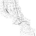
Location of the small fort Zwing and the Limes wall at the time of the Imperial Limes Commission (1895)

Marking stone of the small fort, which is no longer visible
(status July 2009)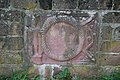
Copy of a Roman relief, walled in at the small fort Zwing, which is no longer visible
(as of August 2007)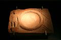
Original of the stone in the Römermuseum Osterburken


Limes course between the small fortifications Zwing and Seitzenbuche

Beginning at the small fort Zwing, the Limes leaves its previous north-south course and takes an east-south-east direction in a wide arc that runs up to Wp 10/35, which it maintains almost linearly to the small fort Seitzenbuche . The course of the Limes leads exclusively through densely forested area, which explains the good state of preservation of the Roman relics. From the Zwing small fort with its 491 meters of altitude, the Limes first rises again by over 60 meters to Wp 10/34 (553 m above sea level), and then drops continuously to 462 meters at the Seitzenbuche small fort.
Limes wall
About 150 m south of the small fort Zwing are the remains of a rather unusual section of the Odenwald Limes. Over a length of 112 m, the Limes was not designed as a palisade, but as a wall made of red sandstone. The reason was probably the difficulty in digging the palisade trench in rocky ground, while stones were there in abundance at the highest point of the Odenwald Limes. The wall is 0.9 m wide and has rounded sandstone blocks at the top. On the "Roman" side, the stones are neatly worked off, while on the side facing away from the empire they are only roughly hewn.

Course of the Limes Wall according to the measurements of the Reich Limes Commission (1895/96)

Findings and stone finds at the time of the commission (1895/96)
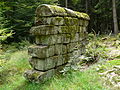
View of the Limes wall, "inside" or Roman side.
(Status July 2009)
Limes wall, outside of the reconstructed section.
(Status August 2007)


| ORL | Name / place | Description / condition |
|---|---|---|
| KK | Small fort Zwing | see above |
| Wp 10/34 |
"In the High Forest" or "Hohwald" |
Not far from the Limes wall is the Wp 10/34 "Im Hohen Wald". The preserved stone tower ruins are visible. The wooden tower site was partially destroyed by a small modern quarry. At the beginning of the 19th century, at the instigation of Count Franz von Erbach, excavations were carried out on this tower in search of “Roman antiquities”. At that time, on Wp 10/34, a cube with the inscription CHO I came to light . It was built into the base of a Limes watchtower (upside down) in the Count's park. The inscription refers to the Cohors I Sequanorum et Rauracorum , who were stationed in the Oberscheidental fort . Their commander had to manage a longer section of the border and was also responsible for the construction of the local towers. Further excavations were carried out - as at all the tower points in this Limes section - in 1896. The stone tower had a square floor plan with a side length of 5.20 m and walls one meter thick. On the outside there were still remnants of the white plaster painted with red dummy joints. The finds accompanying the excavation included two remains of piers and twelve cannon balls made of red sandstone with diameters between 10 cm and 22 cm. The wooden tower, the hill of which had already been badly damaged by quarrying at the time of the commission, was about 13 m north of the stone tower. The Limes Palisade passed the tower group at a distance of 33.35 m from the stone tower and around 30 m from the wooden tower.
|
| Wp 10/35 | "At the monastery forest" |
Stone tower ruins located on a slope together with two tower mounds of the wooden previous buildings. The stone tower had a square floor plan with a side length of 5.25 m, the thickness of its walls was 90 cm. Among the numerous building fragments in the found material there was an inscription panel, the building inscription of the tower, which and thus the construction of the tower could be dated to the year 146 AD. The inscription reads (heavily supplemented):
Translated: “To the Emperor Caesar, the son of the deified Hadrian, Titus Aelius Hadrianus Antoninus Pius, Pontifex Maximus, in the eighth year of his tribunician power, four times consul, father of the fatherland, from the Britones Triputienses. The year in which Clarus and Severus were consuls for the second time. " The upper wooden tower hill, located directly next to the stone tower, is still relatively high and has a diameter of 15 m from trench edge to trench edge (nine to ten meters from trench center to trench center). The lower wooden tower hill is very flat and has a diameter of 25 m. The distance of the palisade ditch was 32 m from the front of the stone tower and about 30 m from the wooden towers.
|
| Wp 10/36 |
"Am Fischerpfad" or "Am Fischerspfad" |
Wooden tower hill with ring moat and preserved stone tower foundation. The stone tower had a square floor plan with a side length of 5.75 m, the wall thickness was 80 cm. The wooden tower was located twelve meters southeast of the stone tower, its ring trench had an outer diameter of 23 m (19 m from the bottom of the trench to the bottom of the trench). The Limes palisade passed the stone tower at a distance of 21.5 m, the wooden tower at a distance of almost 20 m. 3.85 m behind the palisade ditch, the two-meter-wide, graveled Limes accompanying path could be located.
|
| KK | Small fort Seitzenbuche |
|


_2012-09-30_080.jpg)


Monument protection
The small fort in Zwing and the ground monuments mentioned are protected as registered cultural monuments under the Monument Protection Act of the State of Baden-Württemberg (DSchG) . Investigations and targeted collection of finds are subject to approval, and accidental finds are reported to the monument authorities.
See also
literature
- Dietwulf Baatz : Fort Hesselbach and other research on the Odenwald Limes. Gebr. Mann, Berlin 1973, ISBN 3-7861-1059-X (Limes research, volume 12).
- Dietwulf Baatz: The Roman Limes. Archaeological excursions between the Rhine and the Danube. Gebr. Mann, Berlin 2000, ISBN 3-7861-2347-0 , pp. 194f.
- Ernst Fabricius , Felix Hettner , Oscar von Sarwey (eds.): The Upper Germanic-Raetian Limes of the Roemerreiches , Section A, Volume 5: Route 10 (The Odenwald Limes from Wörth am Main to Wimpfen am Neckar), 1926, 1935, p. 69 –79 as well as plates 1, 8–9 and 10, fig. 1.
- Christian Fleer: Typification and function of the small buildings on the Limes. In: Egon Schallmayer (Ed.): Limes Imperii Romani. Contributions to the specialist colloquium “Limes World Heritage Site” in November 2001 in Lich-Arnsburg. Bad Homburg v. d. H. 2004, ISBN 3-931267-05-9 , pp. 75-92 (Saalburg-Schriften 6).
- Holger Göldner, Fritz-Rudolf Herrmann: Sentry 10/30 “In the bird tree hedges” and Hesselbach fort on the Odenwald Limes . Office for Monument Preservation Hessen, Wiesbaden 2001, ISBN 3-89822-154-7 (Archaeological Monuments in Hessen, 154).
- Gerhard Hoffmann: Odenwald Limes in the Neckar-Odenwald district . In: Philipp Filtzinger (Ed.): The Romans in Baden-Württemberg . 3rd edition, Theiss, Stuttgart 1986, pp. 363-3365.
- Dieter Planck (Ed.): The Romans in Baden-Württemberg: Roman sites and museums from Aalen to Zwiefalten. Theiss, Stuttgart 2005, ISBN 3-8062-1555-3 , pp. 187f.
- Egon Schallmayer : The Odenwald Limes. Along the Roman border between the Main and Neckar. Theiss, Stuttgart 2010, ISBN 978-3-8062-2309-5 , pp. 110-112.
- Egon Schallmayer: The Odenwald Limes. Latest research results. Contributions to the scientific colloquium on March 19, 2010 in Michelstadt . Saalburg Museum, Bad Homburg 2012, ISBN 978-3-931267-07-0 (Saalburg-Schriften, 8)
Web links
- Small fort Zwing ( memento of October 24, 2007 in the Internet Archive ) on the old site of the Odenwald Regional Society (OREG)
- Small fort Jägerwiese on the private Limes project page of Claus te Vehne
Individual evidence
- ↑ Ernst Fabricius, Felix Hettner, Oscar von Sarwey (ed.): The Upper Germanic-Raetian Limes des Roemerreiches , Department A, Volume 5: Route 10 (The Odenwald Limes from Wörth am Main to Wimpfen am Neckar), 1926, 1935, pp. 69–79 as well as plates 1, 8–9 and 10, fig. 1.
- ^ A b Egon Schallmayer: The Odenwald Limes. Along the Roman border between the Main and Neckar. Theiss, Stuttgart 2010, ISBN 978-3-8062-2309-5 , pp. 110f.
- ↑ CIL 13, 6512 .
- ↑ Dietwulf Baatz : Sentry 10/34 on the high forest . In: Walter Sölter (Ed.): The Roman Germania from the air . 2nd Edition. Gustav Lübbe Verlag, Bergisch Gladbach 1983, ISBN 3-7857-0298-1 , p. 91.
- ↑ Egon Schallmayer: The Odenwald Limes. Along the Roman border between the Main and Neckar. Theiss, Stuttgart 2010, ISBN 978-3-8062-2309-5 , p. 111.
- ↑ CIL 13, 6511 .
- ↑ Egon Schallmayer: The Odenwald Limes. Along the Roman border between the Main and Neckar. Theiss, Stuttgart 2010, ISBN 978-3-8062-2309-5 , p. 111f.
- ↑ Egon Schallmayer: The Odenwald Limes. Along the Roman border between the Main and Neckar. Theiss, Stuttgart 2010, ISBN 978-3-8062-2309-5 , p. 112.
Remarks
- ↑ ORL = numbering of the Limes structures according to the publication of the Reich Limes Commission on the O bergermanisch- R ätischen- L imes
- ↑ KK = unnumbered K linseed K astell.
- ↑ Wp = W oh p east, watch tower. The number before the slash denotes the Limes section, the number after the slash denotes the respective watchtower.
- ↑ Wp 10/34 th on the private Limes project page of Claus Vehne.
- ^ Wp 10/35 on the private Limes project page by Claus te Vehne.
- ^ Wp 10/36 on the private Limes project page by Claus te Vehne.
- ↑ 49 ° 33 '2.19 " N , 9 ° 7' 20.74" E