
Hesselbach (Oberzent)
|
Hesselbach
City of Oberzent
Coordinates: 49 ° 34 ′ 28 " N , 9 ° 5 ′ 23" E
|
|
|---|---|
| Height : | 485 m above sea level NHN |
| Area : | 7.17 km² |
| Residents : | 169 (December 31, 2018) |
| Population density : | 24 inhabitants / km² |
| Incorporation : | 1st October 1971 |
| Incorporated into: | Hesseck |
| Postal code : | 64760 |
| Area code : | 06276 |
_von_SO.jpg)


Hesselbach is a district of the city of Oberzent (until January 1, 2018 district of Hesseneck ) in the Odenwaldkreis in southern Hesse . The place has around 170 inhabitants and is located in the south-easternmost tip of the state in the immediate vicinity of the triangle between Hesse, Baden-Württemberg and Bavaria . Hesselbach became known nationwide through the important Roman provincial archaeological excavations that took place there from 1966 to 1968.
Geographical location
The place is located in a bulge of the Hessian state border, which includes the south-west bordering Badisch-Schöllenbach . From here over south to southeast lies Baden-Württemberg and Bavaria borders in the northeast. In the west are the districts of Kailbach and Schöllenbach and in the south-east are Waldleiningen Castle in the district of Mörschenhardt (Baden-Württemberg). Since 1837, a 1.3 m high border stone has marked the triangle where the borders of Baden, Bavaria and Hesse meet. Surrounded by pasture and arable land, orchards and a kilometer-wide cordon of dense mixed forests, Hesselbach is located at an average of just under 500 m above sea level on a high plateau sloping slightly to the south, steeply to the east and west in the red sandstone area of the Odenwald . This high plateau is part of the mountain range running north-south through the Odenwald, which rises between Mümlingtal and Ittertal in the west and between Maintal , Mudtal and Elztal in the east.
history
Prehistory and early history
As in the entire region, there are no traces of pre-Roman human settlement in the Hesselbach district. The region, which has always been covered with little fertile soil and overgrown by dense forests, offered the people of the early days no incentive to stay there.
Roman times
It was not until around the year 100 to 160 AD that the place where Hesselbach would later be built became the site of a Roman border garrison of what is now known as the Odenwald Limes . During this time there was the fortification of a numerus , a two centuries , so around 160 men strong auxiliary unit . The fort excavations under the direction of Dietwulf Baatz from 1966 to 1968 and the resulting publication were groundbreaking for provincial Roman archeology and made Hesselbach the “reference fort ” for the entire Odenwald Limes.
middle Ages
The centuries following the end of Roman rule in 260 up to the High Middle Ages are again in the dark. Neither written nor archaeological sources give evidence of a possible settlement. The area was probably deserted. The Franks, who ruled the country after the Alamanni , penetrated deep into the Odenwald, settled there and divided the area into Gaue . However, their settlement activities were limited to areas with sufficiently fertile soil. The rear Odenwald with its barren red sandstone floors did not offer them a sufficient economic basis.
Hesselbach was probably founded between the 10th and 12th centuries by the Benedictine monastery Amorbach on a newly cleared area a little away from the former fort site and laid out as a forest hoof village. The shape and position of the hooves (or "lifts") can still be seen today in the image of the settlement area and in land maps . They stretched in long, narrow strips between the boundaries of the district. Their size was between 15 and 40 hectares, depending on the quality of the soil. They were dimensioned so that they each ensured the existence of a farming family. The structure of the hooves from district boundary to district boundary followed the pattern of forest - arable land - meadow - tree garden - courtyard - tree garden - meadow - arable land - forest, whereby the courtyard with a well was at the lowest point of the site. The hubs were separated from each other by hedges, fences or so-called positioning stones (see below).
From the 12th century, the Lords of Durne seem to have played a certain role for the village as owners of the so-called "Upper Cent ", on whose territory Hesselbach was located, until they sold their rights to the Archdiocese of Mainz in 1271 , where the sovereignty remained until 1803. In addition, the Amorbach monastery and in particular, since the middle of the 14th century as a fief of the Electoral Palatinate , the taverns and later Counts of Erbach as landlords and owners of the "Lower Cent" had extensive rights to the place. Hesselbach was first mentioned in a document in 1334 under the name Heselbuch . While the upper jurisdiction remained continuously with the Archdiocese of Mainz until the beginning of the 19th century - exercised by Mudau as the capital of the " Mudauer Cent " - the complicated ownership structure between the Amorbach monastery and the Erbach family ensured permanent disputes over jurisdiction over the lower jurisdiction in Hesselbach and the resulting income.
In 1395 Hesselbach consisted of 13 hooves, in 1440 of 15 hooves and a "farmstead" without any major property. On the one hand, the number of farms had increased due to the division of inheritance, but on the other hand there were several hooves in one hand, so that overall a slight decrease in population can be assumed. At that time, the mayor of the Amorbach monastery presided over the central courts . The income from their imposed fines were divided between Amorbach and Erbach in a ratio of two thirds to one third, and this distribution key was also used when dividing the large and small tithes .
Modern times
Due to its affiliation to the Amorbach monastery, Hesselbach remained Catholic during the Reformation (from 1517), in contrast to all other villages in the county of Erbach.
Significant events of the German Peasants' War (1525), such as the appointment of Götz von Berlichingen as captain of the " Odenwälder Haufen " in Buchen , the storming and sacking of Amorbach and Wildenberg Castle took place in the immediate vicinity of Hesselbach, but without the place being located directly was affected. Of course, it cannot be ruled out that one or the other dissatisfied Hesselbacher farmer may have participated in the rebels' actions.
During the Thirty Years' War, whose indirect consequences - such as famine and epidemics - almost wiped out the population, the place lay desolate for about 15 years after it had been completely destroyed by fire. Tradition has it that there was only one family left in Hesselbach after the war. The inscription –AN 1662 NO– on the oak beam of a Hesselbach house, which is said to have been visible until a renovation in 1934, testifies to the beginning of the reconstruction . There are documents from 1656 and 1668, according to which Hesselbach belonged to the Amorbach monastery and half to the county of Erbach (1656), or that they had to share the lower jurisdiction (1668). The Archbishop of Mainz had the exclusive hunting rights (1656) and the high level of jurisdiction exercised by Mudau (1668), and the Hesselbachers had to attend church in Mudau (1656). A new, separate church was only built in 1766 (see below).
In 1803 Hesselbach was temporarily added to the short-lived Principality of Leiningen before it became part of the Grand Duchy of Hesse in 1806 . As a result, it belonged to its successor states, from 1918 to 1934 to the People's State of Hesse and - after brief membership of the Nazi Gau Hessen-Nassau (1934 to 1945) and the American Occupation Zone (1945 to 1949) - since 1949 to the federal state of Hesse.
The years around the middle of the 19th century brought high rates of price increases across the country, which also led to severe social imbalances in Hesselbach. The mayor of the village had to buy large quantities of food at the behest of the Erbach district office in order to give it to the poorer population free of charge. At about the same time, he in turn turned to the District Office with a request for the delivery of spinning wheels, with which needy residents should earn a living. Another consequence of the social misery of the 19th century was a dramatic increase in the births of children out of wedlock. In Hesselbach, their share of total births was 9% in the 1810s, but it rose continuously in the following decades until it peaked at 31% in the 1850s. The situation only normalized again towards the end of the 19th century.
| decade | Number of total births | Number of illegitimate births | Proportion of illegitimate births |
| 1811 to 1820 | 54 | 5 | 9.3% |
| 1821 to 1830 | 38 | 9 | 23.7% |
| 1831 to 1840 | 70 | 12 | 17.1% |
| 1841 to 1850 | 79 | 17th | 21.5% |
| 1851 to 1860 | 62 | 19th | 30.7% |
| 1861 to 1870 | 81 | 14th | 17.3% |
| 1871 to 1880 | 95 | 7th | 7.1% |
| 1881 to 1890 | 62 | 5 | 9.7% |
In 1905 the town was connected to the telephone network, and electrification took place in 1927 . In the autumn of 1922, an unprecedented water shortage paralyzed village life. In Schöllenbach, drinking water had to be pumped from the udder into barrels, which were laboriously transported to Hesselbach by horse and cart. There was a similarly severe drought in 1976.
The two world wars also took their toll in Hesselbach. The First World War killed seven men from Hesselbach, and seven dead and an additional five missing Hesselbachers did not return from the Second World War. The population rose from 225 in 1935 and 1939 to 291 in 1945 (+66) through the admission of numerous evacuated bombed-out people. The bomb victims who returned to their cities at the end of the war were followed by a total of 52 displaced persons from 1946 onwards , but their number was significantly reduced again by 1949 as a result of the scarce employment opportunities in Hesselbach.
On the occasion of the regional reform in Hesse , the villages of Hesselbach, Schöllenbach and Kailbach merged on October 1, 1971 to form a community with the new name Hesseneck , which in turn formed the town of Oberzent on January 1, 2018 with other communities.
politics
In the local elections on 27 March 2011 as part of the elections accounted for Ortsbeirat of valid votes (= 72.4%) 218 to the CDU and 83 votes (= 27.6%) of the SPD . The CDU thus won two seats, the SPD one seat on the local advisory board. The local advisory board is a directly elected administrative body of the municipality (in Hessen, among others) , which represents the interests of the local part vis-à-vis the municipality as a whole. He has the right to make proposals and - for all important decisions - to be heard.
Culture and sights
Fort Hesselbach and Odenwald Limes

On the northeastern edge of the village are the remains of the former Hesselbach fort , a Roman fort that was important for research on the Odenwald Limes . The contours of its fence are clearly visible in the terrain as a clear embankment. Furthermore, the traces of the Limes , which ran over the ridge, can be observed very well over a long distance. Various Limes watchtowers can be seen in different states of preservation (partly as soil deformations, partly as reconstructions) in the area. All of these archaeological monuments and reconstructions are provided with information boards. A Limes path leads to the southern neighbor forts, via the fortlet zwing and fortlet Seitz beech to Kastell Schloßau , in northern direction of Limes trail pulls on the Kastell Würzberg to and on to Eulbach . This section of the Limes in its course between the fort Wörth am Main and the forts of Neckarburken (and beyond to Bad Wimpfen) fulfilled its function from the turn of the first to the second century AD until it was about 30 kilometers to the east around the year 160 Direction (line Kastelle von Miltenberg - Kastell Jagsthausen - Kastell Lorch ) was advanced. The Limes hiking trail, marked with a white “L”, is one of the most scenic and historically important hiking trails in Germany in this area of the Rear Odenwald.
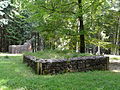
Wooden tower foundation of the tower site Wp 10/30 " In den Vogelbaumhecken " from SSW with a stone tower in the background
(status: July 2009)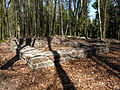
Reconstructed stone tower of the tower site Wp 10/33 " On the Kahler Buckel "
(status: April 2009)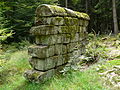
Limes wall at Zwing small fort ; Interior view
(status: July 2009)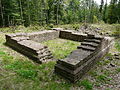
Reconstructed stone tower of the tower site Wp 10/36 " Am Fischerspfad "
(status: July 2009)
Watchtower Wp10 / 37 “ Schneidershecke ” ; Tower B with a replica of the statues of the gods Salus , Mars and Victoria
(as of April 2010)


Cultural monuments
Parish Church of St. Luzia and St. Odilia


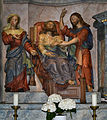
The Catholic parish church of St. Luzia and St. Odilia is centrally located on a western slope in the Catholic town . It was built in 1766 in the shape shown today. However, evidence of a previous building dates back to around 1400 and the finds from the archaeological excavations carried out in 1969 indicate an origin at least in the 13th century. The "Hesselbacher Kreuz" salvaged from a grave inside the church, which is assigned to the creative circle of Rogerus von Helmarshausen , does not make it unlikely that it was erected in the 12th century.

Parish Church of St. Luzia and St. Odilia (April 2009)

Back of the church (June 2011)
Tombstone fragment on the outside of the parish church (April 2009)

Spring place with pulpit in front of the church (April 2009)


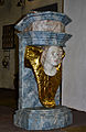
The interior of the church, which looks relatively simple from the outside, contains some art treasures. The baroque high altar, the sculpture of a black Madonna and the duplicate of the Hesselbach cross (the original is in the Hessisches Landesmuseum Darmstadt ) are worth seeing . Directly in the church there used to be a spring, the water of which was said to have healing powers, so that the church was a destination for pilgrimages until the early 19th century and thus one of the most frequented spring shrines in the Odenwald. The source is now a few meters below the church portal.

Baroque high altar

Black Madonna (right side altar)
Carving on the left side altar
Lectern

Organ loft


Former rectory
The former rectory, which was the former hunting seat of the Amorbach abbots, is located at Hauptstrasse 19. The representative, two-story stone building was completed in 1768. A two-flight flight of stairs leads to the entrance, the entrance door and the windows are framed by house stones. Above the portal, together with the coat of arms of the abbots of Amorbach, there is the client's Latin inscription:
- Hiacinthus (Breuer) Abbas et Praelatus Amorbacensis has posuit aede (s) FH
Translated: "Hyacintus Breuer, abbot and prelate of Amorbach, built this building."
Another relief stone from the 18th century, decorated with a rose window and plant clusters, is located in an outbuilding. The fence around the site with its stone posts is also a listed building.
A house
In Wiesenstraße, house no. 9, is the only surviving specimen of an Odenwald single house in the village. The one-story half-timbered building dates from the early 19th century. In a single house, all the functions of a working farm were combined under one roof. It was a combined residential and farm building with livestock in small stables, hay and straw storage under the roof and storage in the brick cellar.
"Stellsteine"

In the “Oberm Brunnen” corridor in the “Bockswiese” there is a field path that, coming from the church, crosses the meadow in a gentle curve and then continues towards Schöllenbach to the west. For a distance of about 100 meters, it is bordered on both sides by upright sandstone slabs. These plates, the so-called standing stones, used to separate the individual hooves from one another. The fact that the stones were on both sides of the path also suggests that they also fulfilled the task of preventing the animals from breaking out when driving cattle.
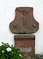
Wayside shrines


A total of eight shrines , all of the status of a cultural monument by the Hessian Denkmalschutzgesetz own, reflected in the townscape, the Catholic imprint of the village in an environment of Protestant dominance. They were built between 1726 and 1840 and are scattered inside and outside the village. The wayside shrines are sandstone bas-relief pictures supported by columns on pedestals, their average height is 2.50 m. There are two types. The older floors (1726–1804) have picture fields framed by volutes , over which there are curved gables, sometimes with a cross. The younger (1804–1840) forms appear as simple aedicules with segmented gables .
The shrines in detail:
| Dating | Hall | location | Inscription / description | image |
| 1726 | next to the church | Plate: Crucifixion Group. Inscription: DIES / BILDT / HAT / FRANT (S) / SCHÖFER VND / ANA CHRISTINA / (MAG) EN LASSEN / 1726 Artist: "Boxbrunner Meister" |

|
|
| 1729 | "Am Kastell 10" (inner courtyard) | Plate: "Walldürner blood picture" (inserted in 1840). Inscription: DIESS / BILT · HAT / LASEN AVF / RIGTEN · JO / HANES / · KRIM SCHV / LTEIS VND / SHINE HA / VS FRAV / ANGNES / 1729 Artist: "Boxbrunner Meister" |

|
|
| 1803 | "Spitzacker" | southeast exit | Panel: Vesper picture; on the side faces Wendelin and Johannes Nepomuk . Shaft: angel head; leaf-like decor. Inscription: EX VOTO JOHANES NOHE V MARGARETA DESEN WIFE ANO 1803 Artist: "Mudauer Meister" |

|
| 1803 | at the inn "Grüner Baum" | Plate: Holy Trinity; of the figures on the side surfaces, only Wendelin can be identified. Shaft: Vesper picture with traces of former painting; Rosettes; on the front plinth field Doppelweck and Spitzweck. Inscription: EX VOTO CASPER GALM V BARBARA DESEN WIFE ANO 1803 Artist: "Mudauer Meister" |

|
|
| 1803 | "In the town" | at the fort |

|
|
| 1804 | "In the cat hole" | southern exit |

|
|
| 1st half of the 19th century | "In the car gap" | north-western outskirts |

|
|
| 1840 | "In the Euterberg" | north of Hesselbach | Destroyed in summer 2012 (see picture), board disappeared |

|
Stone crosses

Three simple stone crosses are also cultural monuments . With the exception of one, the front of which depicts the ax of a woodcutter or carpenter, they have no decorations, inscriptions, dates or stylistic features that could be used to date them. The motives that led to their creation are uncertain. In the Middle Ages, such stone crosses were often erected in places where someone had died innocently but without being able to receive the final sacraments beforehand . Temporary had the possibility, for the soul of the victim or victims prayers to pray. It is possible that some of the Hesselbach crosses are “atonement crosses” that were erected to atone for an offense or crime.
The three crosses in detail:
| material | Dimensions | Dating | location | description | image |
| Sandstone | Height: 89 cm Width: 79 cm Depth: 17 to 22 cm |
unknown | Hallway 2/30 “Im Ort” at the eastern exit of the town |
heavily weathered cross without bevel and without pictorial representation |
|
| Sandstone | Height: 135 cm Width: 105 cm Depth: 20 to 28 cm |
around 1500 | Corridor 2/65 “Oberm Brunnen” on a meadow near the church |
Cross without bevel. On the front side there is the depiction of the ax of a carpenter or woodcutter in flat raised relief technique. The ax type was in use in the late 15th and early 16th centuries. |

|
| Sandstone | Height: 140 cm Width: 88 cm Depth: 22 cm |
unknown | Corridor 1/197 "Steinetsfeld" or "Spitzacker" on the road to Schloßau |
Edges of the cross with clearly pronounced bevels, without pictorial representation |
|
"Dreiländereck" and historical boundary stones at the district boundaries

Since 1837 the point where the borders of Hesse, Baden- (Württemberg) and Bavaria meet has been marked with a 1.3 m high boundary stone. The stone bears the chiseled pairs of letters GH (Grand Duchy of Hesse), GB (Grand Duchy of Baden) and KB (Kingdom of Bavaria), it is only a few minutes' walk from the Hesselbach outskirts. In addition, at the Hesselbach district boundaries, which were also state borders, there are further historical boundary stones, most of which date from the 19th, but some also from the 18th century:
| No. | number |
District border national border |
Inscription / description | location | image |
| Single stone |
Breitenbuch Bayern |
Front: "GH + H" Back: "KB + BR" |
|||
| 43 | several older stones at the new boundary stones | Breitenbuch Bayern |
The year "1780" and a stone number (e.g. "XIIII"); carved crosses | On the forest path to Bullau, on the eastern edge of the Eutertal at 484.0 m above sea level |
|
| two stones | Breitenbuch / Breitenbach Bavaria |
Older stone with stone number "XXXVIII" VS: "GH" above "H" RS: "1780" Younger stone: VS: "GH" above "H" below the coat of arms left: "GB" above "BR" right: "Bba" RS: "KB" below the coat of arms |
_Seite_1.jpg)
|
||
| Single stone | Breitenbach Bavaria |
VS: today no longer legible year "1779", below abbot RS: "2" (stone number) next to "H" |
|||
| Single stone | Breitenbach Bavaria |
VS: "GH" over "H" RS: "KB" over "Bba" |
_Seite_1.jpg)
|
||
| Single stone | Breitenbach / Bavaria Ernsttal (formerly Neubrunn, desert at the beginning of the 19th century) / Baden |
"Dreiländerstein" with a triangular floor plan 1: "GH" over "NI" over "134" over the year "1837" 2: "KB" 3: "GB" over "171" |
|||
| Single stone | Ernst Valley Baden |
VS: "GH" RS: "GB" |
|||
| Single stone | Ernst Valley / Baden | VS: "GH" over "116" right: year "1892" RS: "LG" left: "GB" over "13½" |
|||
| Single stone | Ernsttal, Friedrichsdorf Baden |
VS: "VH" over "102" right: "RB" RS: year "1924" left: "LG" over "20½" |
|||
| Single stone | Friedrichsdorf Baden |
VS: Erbacher coat of arms RS: Mainz wheel |
|||
| Rock marking | Friedrichsdorf Baden |
Erbach'scher star, Mainz wheel and a cross | |||
| Rock marking | Friedrichsdorf Baden |
Erbach'scher Stern, Kreuz and Mainzer Rad; Year "1837" |
|||
| Rock marking | Friedrichsdorf Baden |
Mainz wheel, year "1752", Erbach'scher Stern; cross |
education

The smallest elementary school in Hesse was located in the village community center until 2010 , where four grades were taught together in one class. As early as 1803, Hesselbach was one of the places with its own school, even if it did not initially have its own building and constantly had to use other rooms. However, the rising birth rates in the first half of the 19th century made a separate building necessary, the construction of which finally began in 1834 and was completed in 1835. In 1899 a new, larger school was built after the old building no longer met the growing demands.
After only five pupils attended school in the 2008/2009 school year, the responsible state education authority in Heppenheim decided to close the school. Since then, students of all types of school have had to take the school bus to Beerfelden, 28 kilometers away. Only the “Wirbelwind” kindergarten in neighboring Kailbach is still in the municipality.
Clubs and events
The club life in Hesselbach is essentially shaped by the Hesselbach volunteer fire brigade and the MGV Sängerbund Hesselbach. The two associations also carry out most of the regular and irregular cultural events, which mostly take place in the local village community center.
Economy and Infrastructure


economy
The economy of Hesselbach is characterized by two full-time farms specializing in dairy farming and tourism. Tourism finds its infrastructure in two inns, a larger guesthouse with integrated holiday flats, as well as a few individual vacation rental providers, and in terms of its appearance it can only be assigned to " sustainable tourism ". So Hesselbach staging post and crossroads of the towing from west to east Nibelungen sidewalk , an award-winning trail, and the above described running from north to south Limes trail .
There are no other businesses, and no shops. In addition to the direct sales of the two farms and the drinks offered by the local sales point of a Tauber Franconian brewery, the delivery vehicles of a bakery and a butcher's shop supply the population with bread as well as meat and sausage products once a week. The demand for goods beyond this must be met in the neighboring communities and cities.
traffic
Hesselbach is not directly accessible from the Hessian area because of the border location in the south-east of Hesse with a complicated borderline and because of the traffic-unfavorable valley cut on the upper Itterbach called Eutergrund . Even the direct two-kilometer footpath from Hesselbach to the southwest down to the main town of Schöllenbach mainly leads through the Eutergrund of Badisch-Schöllenbach .
The only road that is classified as supra-local and that leads to Hesselbach is the two-kilometer-long K 40 district road , which reaches the state border in the southeast at Jägerwiese and from there, as K 3919, leads to the Heidenberg pass. From there the state road L 2311 goes to Kailbach and so you finally reach the center of Hesseneck in the district of Schöllenbach on the Itterbach further up the valley with the L 3108 after a total of 15 kilometers. The journey is five kilometers on a restricted-use road that leads via Badisch Schöllenbach . Another road with traffic restrictions leads nine kilometers along the route of the Odenwald Limes to Würzberg , with a longer section on Bavarian territory.
From Hesselbach there is a taxi connection six times a day (Saturday and Sunday twice a day) via Schöllenbach to Beerfelden . A connection to the Odenwaldbahn takes place via the Hesseneck Schöllenbach stop ( Schöllenbach-Hesselbach until 2006 ). Other bus connections are also available from Schöllenbach. The buses go in the direction of Eberbach and Beerfelden.
literature
- Friedrich Karl Azzola : The late medieval stone cross of a woodcutter, woodcutter, carpenter near Hesselbach, municipality of Hesseneck in the Odenwald district, around 1500. On the iconography and function of a late medieval ax with an extremely long neck. In: Der Odenwald , Vol. 52 (2005), 2, pp. 65-75.
- Friedrich Karl Azzola: Two further iconographic documents (1502/1505) on the long-necked and at the same time short-edged ax as a symbol of the Hesselbach stone cross. In: The Odenwald. Vol. 56 (2009), 4, pp. 158-161.
- Dietwulf Baatz : Fort Hesselbach and other research on the Odenwald Limes. Gebr. Mann, Berlin 1973, ISBN 3-7861-1059-X (Limes research, volume 12)
- Dietwulf Baatz: The numerus fort Hesselbach (Odenwald). Short report. In: Saalburg yearbook. 25, 1968, pp. 185-192.
- Dietwulf Baatz: Hesseneck-Hesselbach. In: ders. And Fritz-Rudolf Herrmann (ed.): The Romans in Hessen. Licensed edition, Nikol, Hamburg 2002, ISBN 3-933203-58-9 , p. 348f.
- Dietwulf Baatz: The Roman Limes. Archaeological excursions between the Rhine and the Danube. Gebr. Mann, Berlin 2000, ISBN 3-7861-2347-0 , pp. 192-194.
- Hugo Friedel: State border near Hesselbach. Small monuments - witnesses of a cultural landscape. In: Odenwald-Heimat. Vol. 77 (2002), 8, p. 32.
- Holger Göldner, Fritz-Rudolf Herrmann : Sentry 10/30 “In the bird tree hedges” and Hesselbach fort on the Odenwald Limes . Office for Monument Preservation Hessen, Wiesbaden 2001, ISBN 3-89822-154-7 (Archaeological Monuments in Hessen, 154)
- Margot Klee : The Roman Limes in Hessen. History and sites of the UNESCO World Heritage. Verlag Friedrich Pustet, Regensburg 2009, ISBN 978-3-7917-2232-0 , pp. 196-199.
- Elisabeth Kleeberger: Territorial history of the rear Odenwald. County of Erbach, dominion of Breuberg, dominion of Franconian-Crumbach. (= Writings of the Hessian State Office for Historical Regional Studies, 26). 2nd Edition. Elwert, Marburg 1987, ISBN 3-7708-0867-3 , pp. 129-134.
- State Office for the Preservation of Monuments Hesse (ed.); Hans Teubner and Sonja Bonin: Monument topography Federal Republic of Germany. Cultural monuments in Hessen. Odenwaldkreis . Vieweg, Wiesbaden 1998, ISBN 3-528-06242-8 , pp. 345-350.
- Eberhard Rosewick: Hesselbach. Local history of a hill village in the rear Odenwald . Hesselbach, 1949.
- Georg Schäfer: Art monuments in the Grand Duchy of Hesse. Starkenburg province, Erbach district . Bergstraeßer, Darmstadt 1891, pp. 128-134.
- Egon Schallmayer : The Odenwald Limes. Along the Roman border between the Main and Neckar. Theiss, Stuttgart 2010, ISBN 978-3-8062-2309-5 , pp. 104-110.
- Hans Teubner, Sonja Bonin: Cultural monuments in Hessen. Odenwaldkreis . Vieweg, Braunschweig 1998, ISBN 3-528-06242-8 , pp. 344-350.
- Karl-Heinz Winter: The rulership in the surrounding area of Hesselbach until 1806. In: Gelurt. Vol. 1 (1995), ISSN 0947-4870 , pp. 41-49.
- Literature about Hesselbach in the Hessian Bibliography
Web links
- Hesselbach. In: website. City of Oberzent
- Hesselbach, Odenwaldkreis. Historical local dictionary for Hessen. In: Landesgeschichtliches Informationssystem Hessen (LAGIS).
- Hesselbach and the Odenwald Limes. In: hesselbach-odenwaldlimes.de. Private website
Remarks
- ↑ In addition, the spellings Heselbüch (1415), Hesselbuch (1435 and 1465), Haselbuch (1443), Heselbach (1443 and 1517), Hesselbach (first 1487), Hasselbach (1607), Haiselbach (1656) and Hässelbach (1668) ) documented.
- ↑ According to E. Rosewick according to a parish chronicle from the year 1908th
- ↑ Hyazinth Breuer * 19. June 1712 in Ladenburg , † 28. May 1794 in Amorbach was elected abbot of the Amorbach monastery since April 14, 1753.
- ↑ Height measurements measured above ground
- ↑ Grand Duchy of Hesse
- ↑ Hesselbach
- ^ Kingdom of Bavaria
- ↑ Breitenbuch
- ↑ "+" stands for a carved cross on the front and back.
- ↑ Is interpreted as Breitenbach .
- ^ Grand Duchy of Baden
- ↑ "LG" = "national border"
- ^ People's State of Hesse
- ↑ "Reich Baden"
Individual evidence
- ↑ Hesselbach, Odenwaldkreis. Historical local dictionary for Hessen. (As of October 17, 2018). In: Landesgeschichtliches Informationssystem Hessen (LAGIS).
- ↑ Numbers and dates. In: website. City of Oberzent, accessed March 2019 .
- ↑ a b See also Dietwulf Baatz: Fort Hesselbach and other research on the Odenwald Limes. (Limes research, 12). Gebr. Mann, Berlin 1973.
- ↑ a b Eberhard Rosewick: Hesselbach. Local history of a hill village in the rear Odenwald . Hesselbach, 1949, p. 19.
- ↑ After Eberhard Rosewick: Hesselbach. Local history of a hill village in the rear Odenwald . Hesselbach, 1949, p. 80.
- ↑ a b Eberhard Rosewick: Hesselbach. Local history of a hill village in the rear Odenwald . Hesselbach, 1949, pp. 19-33.
- ↑ Eberhard Rosewick: Hesselbach. Local history of a hill village in the rear Odenwald . Hesselbach, 1949, pp. 33-38.
- ↑ Jurisdiktionalbücher the Centen Amorbach, Mudau, Buchen, Walldürn, (Easter) Osterburken ( Memento of 6 May 2014 Internet Archive ), 1656 and the 1668th
- ↑ Eberhard Rosewick: Hesselbach. Local history of a hill village in the rear Odenwald . Hesselbach, 1949, pp. 33-41.
- ↑ Eberhard Rosewick: Hesselbach. Local history of a hill village in the rear Odenwald . Hesselbach, 1949, pp. 84f.
- ↑ Eberhard Rosewick: Hesselbach. Local history of a hill village in the rear Odenwald . Hesselbach, 1949, p. 78.
- ↑ Eberhard Rosewick: Hesselbach. Local history of a hill village in the rear Odenwald . Hesselbach, 1949, p. 79f.
- ↑ Eberhard Rosewick: Hesselbach. Local history of a hill village in the rear Odenwald . Hesselbach, 1949, pp. 89f.
- ^ Federal Statistical Office (ed.): Historical municipality directory for the Federal Republic of Germany. Name, border and key number changes in municipalities, counties and administrative districts from May 27, 1970 to December 31, 1982 . W. Kohlhammer, Stuttgart / Mainz 1983, ISBN 3-17-003263-1 , p. 358 .
- ↑ Section 81, Paragraph 1, Clauses 1 - 3 HGO.
- ↑ See also Holger Göldner: Wachtposten 10/30 "In den Vogelbaumhecken" and Kastell Hesselbach at the Odenwald Limes . Leaflet to the reconstructed Limes section and the fort near Hesseneck-Hesselbach, Odenwaldkreis. Department of Archaeological and Paleontological Monument Preservation in the State Office for Monument Preservation Hessen, Wiesbaden 2001, ISBN 3-89822-154-7 .
- ↑ Dietwulf Baatz: The Roman Limes. Archaeological excursions between the Rhine and the Danube . Gebr. Mann, Berlin 2000, ISBN 3-7861-2347-0 .
- ^ Ernst Fabricius , Felix Hettner , Oscar von Sarwey (ed.): The Upper Germanic-Raetian Limes of the Roemerreiches , Section A, Volume 5: Route 10 (The Odenwald Limes from Wörth am Main to Wimpfen am Neckar), 1926, 1935.
- ^ Hesselbacher Cross. In: Real Lexicon on German Art History . Metzler, Stuttgart 1937, Volume 3, Column 721 f.
- ^ Norbert wall: St. Lucia in Hesselbach . In Ders .: Medieval hermitages, spring shrines and pilgrimage sites in the Odenwald. Laurissa, Heppenheim 1995, ISBN 3-922781-51-9 .
- ↑ a b c d e On the official website of the Hesse Monument Preservation .
- ↑ Egon Schallmayer: The Odenwald Limes. Along the Roman border between the Main and Neckar . Theiss, Stuttgart 2010, ISBN 978-3-8062-2309-5 , p. 106; after Heinz Schmitt: Spring shrines in the Odenwald. In: Contributions to the exploration of the Odenwald and its peripheral landscapes. 4, 1986, p. 475.
- ↑ a b Fritz Schäfer: The influence of folk art on the spread of the panel picture stock in the eastern Odenwald during the 1st half of the 18th century. Shown using the example of two groups of wayside shrines from the Boxbrunn - Beuchen - Schöllenbach area. In: Winfried Wackerfuß (Ed.): Contributions to the exploration of the Odenwald and its peripheral landscapes IV . Breuberg-Bund, Breuberg-Neustadt 1986, ISBN 3-922903-00-2 , pp. 547–468 and Fig. 1–31.
- ↑ a b Fritz Schäfer: The Mudauer Meister. Study of the wayside shrines and the person of an Odenwald folk artist. In: Winfried Wackerfuß (Ed.): Contributions to the exploration of the Odenwald and its peripheral landscapes III . Breuberg-Bund, Breuberg-Neustadt 1980, ISBN 3-922903-00-2 , pp. 383-422.
- ^ Friedrich Mössinger: Stone crosses between the Rhine, Main and Neckar. In: Archive for Hessian History and Archeology (AHG), New Series 19, Darmstadt 1936, pp. 49–98.
- ↑ Eberhard Rosewick: Hesselbach. Local history of a hill village in the rear Odenwald . Hesselbach, 1949, pp. 92-94.
- ↑ Friedrich Karl Azzola: The late medieval stone cross of a lumberjack, wood cutter, carpenter near Hesselbach, municipality of Hesseneck in the Odenwald district, around 1500. On the iconography and function of a late medieval ax with an extremely long neck. In: The Odenwald. Vol. 52 (2005), 2, pp. 65-75.
- ↑ Friedrich Karl Azzola: Two further iconographic documents (1502/1505) on the long-necked and at the same time short-edged ax as a symbol of the Hesselbach stone cross. In: The Odenwald. Vol. 56 (2009), 4, pp. 158-161.
- ↑ Eberhard Rosewick: Hesselbach. Local history of a hill village in the rear Odenwald . Hesselbach, 1949, pp. 80-101.
- ^ Hugo Friedel: State border near Hesselbach. Small monuments - witnesses of a cultural landscape . Odenwald-Heimat, Vol. 77 (2002), H. 8, p. 32.
- ↑ Christina Best: I call her my family business. Hesse's smallest primary school is in Hesselbach. One teacher, 15 students . Darmstädter Echo, Vol. 50 (1994), H. 203 (01.09.), P. 35.
- ↑ Eberhard Rosewick: Hesselbach. Local history of a hill village in the rear Odenwald . Hesselbach, 1949, pp. 66-73.
- ^ Frankfurter Allgemeine Zeitung - Only three students left: Smallest Hessian elementary school closes
- ↑ Register of associations ( Memento from September 24, 2015 in the Internet Archive ) (PDF; 11 kB) of the municipality of Hesseneck.
- ↑ See the event calendar of the community of Hesseneck.
- ↑ " To the Green Tree " and "Three Lilies"
- ↑ " Am Limes path
Airlenbach | Beerfelden | Etzean | Hawk buttocks | Finkenbach | Gammelsbach | Lifting steel | Hesselbach | Hetzbach | Hinterbach | Kailbach | Kortelshütte | Ober-Hainbrunn | Ober-Sensbach | Olfen | Raubach | Rothenberg | Schöllenbach | Unter-Sensbach