Langenberg (Odenwald)
| Langenberg | ||
|---|---|---|
|
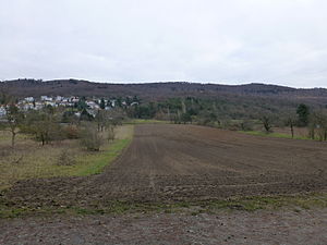
View from a farm road west of Malchen eastwards to Langenberg: Ilbes-Berg (left, above Malchen), middle knoll (center), southern knoll (center right), part of Galgenberg (right at the edge of the picture) |
||
| height | 430 m above sea level NHN | |
| location | near Nieder-Beerbach ; Darmstadt-Dieburg district , Hesse ( Germany ) | |
| Mountains | Odenwald | |
| Dominance | 5.4 km → Kuralpe am Felsberg | |
| Notch height | 132 m ↓ Crossroads northwest of Ober-Beerbach | |
| Coordinates | 49 ° 46'59 " N , 8 ° 40'5" E | |
| Topo map | LAGIS Hessen | |
|
|
||
| rock | Crystalline Odenwald , Frankenstein Complex | |
| Age of the rock | about 360 million years | |
The Langenberg in the Hessian district of Darmstadt-Dieburg forms the southern part of the Frankenstein massif belonging to the Odenwald with its highest elevations. Due to its height of about 430 m above sea level, which towers over all neighboring peaks in the northwest of the Vorderen Odenwald . NHN it shows itself as the north-western edge mountain of this low mountain range. The Langenberg takes its name from the elongated west flank that towers high and steep above Seeheim-Jugenheim on the Bergstrasse .
geography
location
The Langenberg is located in the north of the Bergstrasse-Odenwald Nature Park . It rises between the Darmstadt district of Eberstadt in the north-northwest, the Mühltal district of Nieder-Beerbach in the east, Ober-Beerbach in the southeast and Malchen in the west, two districts of the Seeheim-Jugenheim southwest of the mountain .
The northern part of the Langenberg falls to the east into the valley of the Beerbach with the village of Nieder-Beerbach (approx. 223 m ), the boundary of which includes the high elevations of the Langenberg, and the southern part also falls in this direction to the Beerbach, that of Ober -Beerbach (approx. 300 m ) flows towards it . The White Mountain ( 330.4 m ) in the transition area to the Beerbach creates a connection to the ridge, which leads south-southeast to the Felsberg ( 514 m ) six kilometers away . The southern part drops to the southeast and east to the Elsbach , a tributary of the Zehntbach ( Landbach ) . In the south the Langenberg runs out over the Galgenberg ( 374.8 m ) and the Karlshöhe ( 257.3 m ); According to some considerations, the latter is no longer counted as part of the Langenberg.
Mountain heights and crests
The Langenberg has three peaks which exceed the 400 m height line : The north peak is the Ilbes-Berg ( 419.7 m ), the landscape of which leads north to the Schloßberg (approx. 370 m ) with Frankenstein Castle . About 500 m south of the summit of the Ilbes mountain, the uppermost labeled 430 m contour line of the central dome forms an approximately 1.6 ha large oval in which the summit of the Langenberg is located, which has not been given an exact height in topographical maps ; A wooden refuge stands on this hilltop. About 650 m south of it is the unnamed south crest , which is 421.6 m high.
Natural allocation
The Langenberg belongs to the natural spatial main unit group Odenwald, Spessart and Südrhön (No. 14), in the main unit Vorderer Odenwald (145) and in the subunit Melibokus-Odenwald (145.0) to the natural area Frankenstein massif (145.01). While the landscape merges to the east into the natural area 145.02, the sub-unit Northern Bergstrasse (226.5) joins the main unit group Northern Upper Rhine Lowland (22) and the main unit Bergstrasse (226) in the west.
Individual evidence
- ↑ a b c d Deutschlandviewer , on onmaps.de
- ↑ a b Map services of the Federal Agency for Nature Conservation ( information )
Web links
Geo-Naturpark (Bergstrasse-Odenwald) , on geo-naturpark.de

