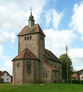
Boxbrunn in the Odenwald
|
Boxbrunn
City of Amorbach
Coordinates: 49 ° 39 ′ 55 " N , 9 ° 6 ′ 38" E
|
|
|---|---|
| Height : | 488 m |
| Area : | 12 km² |
| Residents : | 136 (Jun. 30, 2016) |
| Population density : | 11 inhabitants / km² |
| Incorporation : | April 1, 1973 |
| Postal code : | 63916 |
| Area code : | 09373 |
|
St. Wendelin Church, view from Nibelungenstrasse
|
|
Boxbrunn in the Odenwald is a district of Amorbach in the Miltenberg district in Bavaria on the border with Hesse .
Geographical location
The parish village of Boxbrunn is located ten kilometers west-northwest of the core town of Amorbach on an elongated plateau about 500 meters narrow. This leads from Winkelberg 484 m near the city center over the narrow plane 495 m and the Neidhof 490 m through the local area of Boxbrunn. After another three kilometers, it reaches the watershed between Mud and Mümling on the other side of the state border near Eulbach . The field markings form a clearing island on the plateau in the wooded area of the sandstone Odenwald . This is also where Boxbrunn's highest peaks are located. To the south-east of the location, the Boxbrunn water tower reaches 505 m and to the north-west of the location, just before the state border, Auf der Höhe - already mainly located beyond the clearing - 504 m. The location is on the saddle between these two elevations and forms a radius of around five hundred meters in loosened development.
history
Boxbrunn was created from clearing of the Amorbach Abbey . The existence of "Bockesbrunn" can be traced back to a document dated July 27, 1310. The Thirty Years War left the place largely depopulated, similar to the neighboring Eulbach. The location on the already busy interurban road at that time led to the passage of troops with correspondingly disadvantageous consequences for the people living there.
In 1868 the predominantly Catholic residents received their own branch church, St. Wendelin . During the expansion in 1911, the characteristic wide choir tower was built.
Boxbrunn was incorporated into the city of Amorbach on April 1, 1973 as part of the regional reform in Bavaria .
Transport and infrastructure
The federal highway 47, known as Nibelungenstrasse , runs through Boxbrunn from Amorbach to Michelstadt .
Because of the great scarcity of drinking water in the high-altitude place, the wild meadow spring in the gorge between Boxbrunn and Würzberg near the state border was opened up in 1960. The drinking water pumped there filled a 30 m high water tower with a capacity of approx. 60 m³, which was also erected on the eastern edge of the town . Its distinctive profile became a landmark of the place. In 2009 the water tower was decommissioned and replaced by a pressure storage system with two tanks with a capacity of 80 m³ each.
Individual evidence
Web links
- Boxbrunn on the website of the city of Amorbach
- Boxbrunn on the Internet (as of 2012)
- Reichartshausen in the location database of the Bavarian State Library Online . Bavarian State Library

