
Bromskirchen
| coat of arms | Germany map | |
|---|---|---|

|
Coordinates: 51 ° 6 ' N , 8 ° 38' E |
|
| Basic data | ||
| State : | Hesse | |
| Administrative region : | kassel | |
| County : | Waldeck-Frankenberg | |
| Height : | 414 m above sea level NHN | |
| Area : | 35.23 km 2 | |
| Residents: | 1927 (Dec. 31, 2019) | |
| Population density : | 55 inhabitants per km 2 | |
| Postal code : | 59969 | |
| Area code : | 02984 | |
| License plate : | KB, FKB, WA | |
| Community key : | 06 6 35 005 | |
| LOCODE : | DE BKC | |
| Community structure: | 5 districts | |
| Address of the municipal administration: |
Unterm Stein 2 59969 Bromskirchen |
|
| Website : | ||
| Mayor : | Ottmar Vöpel | |
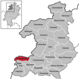
| Location of the municipality of Bromskirchen in the Waldeck-Frankenberg district | ||
  |
||


Bromskirchen is a municipality in the Waldeck-Frankenberg district in northern Hesse .
geography

Bromskirchen is on the edge of the Rothaargebirge in the southwest of the Waldeck-Frankenberg district, close to the border with the North Rhine-Westphalian Hochsauerlandkreis .
More than 70% of the municipal area consists of forest.
Neighboring communities
Bromskirchen borders in the north on the city of Hallenberg ( Hochsauerlandkreis in North Rhine-Westphalia ), in the east on the city of Frankenberg , in the south on the municipality of Allendorf and the city of Battenberg (all three in the district of Waldeck-Frankenberg), and in the west on the city of Bad Berleburg ( Siegen-Wittgenstein district in North Rhine-Westphalia).
Community structure
- Bromskirchen
- Badger hole
- Neuludwigsdorf
- Seibelsbach
- Somplar
history
Fromoldeskirchen, with its mutilated Martins Basilica, a suburb of a Battenberger Kleinzent in 1238, was originally a Carolingian Höhenweg settlement of royal people. In 1238 the community was first mentioned in a note from the Archdiocese of Mainz . Historically documented names of the place were: Fromolskirke (1238), Fromoldeskirchen (1291), Frumboldeskirchen (1359), Fromißkirchen (1394), Brommelskirchen (1473).
In the course of the Middle Ages, the village and court of Bromskirchen experienced numerous changes of ownership: The Lords of Itter initially lent it to the Lords of Beltershausen , who sold it to the Lords of Diedenshausen in 1329 . In 1394/95 it was bought by the lords of Viermünden , who sold it to the Landgraves of Hesse in 1539 . After the Thirty Years' War the village came from Hessen-Kassel to Hessen-Darmstadt and in 1866 to Prussia .
The authority over the local church is to be distinguished from secular sovereignty. Ecclesiastical sovereignty belonged to the Counts of Waldeck , who were related by marriage to Itter , who enfeoffed the Lords of Girkhausen in 1332 and finally the nobles (von) Winter with it in 1473. It stayed with these until they died out around 1785.
The statistical-topographical-historical description of the Grand Duchy of Hesse reports on Bromskirchen in 1830:
"Bromskirchen (L. Bez. Battenberg) evangel. Parish village; is on the Prussian border, 2 1 ⁄ 2 hours from Battenberg on a hill. The place has 154 houses with 943 inhabitants, among which 3 Cath., 4 Mennonites and 25 Jews are. Bromskirchen, which is in a very rough area, has a very large area; 3 cattle markets are held annually. - The village probably came from the Lords of Battenberg to the Mainz archbishopric, which in 1464 gave it to Landgrave Heinrich III with other places. pledged. According to a directory from the 15th century, the places Ewerthusen , Ruperthusen , Eymannshusen , Lymphe and Belchershusen belonged to the church area of Bromskirchen, which was called Fromelskirch or Fromeldis churches , but none of them exist anymore. "
In the course of the regional reform in Hesse , Somplar was incorporated into Bromskirchen on February 1, 1971.
For centuries the place was characterized by agriculture on barren soils and the forest.
Bromskirchen Monastery
The theory that Martins Basilica was the center of a nunnery belonging to the Benedictine Order has been discussed for a long time. Evidence of this can only be found in a chronicle of the neighboring village of Hallenberg and in a description of the Battenberg office around 1750. According to the chronicle, the monastery is said to have been destroyed around 1518.
Train with V2 rockets in Bromskirchen
In 1945 Bromskirchen became known worldwide for a short time when a complete train with V2 rockets was captured by troops of the US Army . This train was directed on March 22nd coming from Driedorf (Westerwald) as an extra-long military train via Herborn to the Aar-Salzböde-Bahn . It was over a kilometer long and was pulled by two locomotives (type G 8 ), another was in the middle, a fourth pushed from behind. He was attacked by American fighter bombers at Bicken around eight o'clock and later at Bischoffs ; one locomotive was damaged (through the boiler), with heavy resistance from the four-in-one flaks . The train was then divided into Bischoffen and reached the 700 m long tunnel near Hartenrod towards evening, where it protruded from the front. Two days later he was driven to Marburg. After an odyssey through Marburg, Wetter, Frankenberg and Allendorf, the rocket train on the way to Winterberg reached Bromskirchen station on March 29th. American tanks stopped him there around nine o'clock when the locomotives wanted to refuel . With this V2 battery train from the Süd-Art.Rgt. (Mot.) Group zV901, Section Ia, camouflaged under tarpaulin , the Americans got their hands on ten complete V2 rockets including fuel, railway launch pads, armored personnel carriers and flak wagons as well as the operating instructions . Three days later they had the train taken to Antwerp. From there the cargo was shipped to America and thus contributed significantly to the development of American missile technology. Until then, the Americans only knew the V2 from its fragments after the impact. This move was also discussed in detail in Allied newsreels.
Territorial history and administration
The following list gives an overview of the territories in which Bromskirchen was located or the administrative units to which it was subordinate:
- 1238: Holy Roman Empire , County of Stiffe (-Battenberg), Cent Bromskirchen
- from 1571: Holy Roman Empire, Landgraviate Hessen-Marburg , Wolkersdorf Office, Röddenau Court
- 1604–1648: disputed between Hessen-Kassel and Hessen-Darmstadt ( Hessenkrieg )
- from 1604: Holy Roman Empire, Landgraviate Hessen-Kassel, Amt Battenberg
- from 1627: Holy Roman Empire, Landgraviate Hesse-Darmstadt , Upper Duchy of Hesse , Office of Battenberg
- from 1806: Grand Duchy of Hesse , Upper Duchy of Hesse, Office of Battenberg
- from 1815: German Confederation , Grand Duchy of Hesse, Province of Upper Hesse , Battenberg Office
- from 1821: German Confederation, Grand Duchy of Hesse, Province of Upper Hesse, District Battenberg
- from 1832: German Confederation, Grand Duchy of Hesse, Province of Upper Hesse, Biedenkopf district
- from 1848: German Confederation, Grand Duchy of Hesse, Biedenkopf district
- from 1852: German Confederation, Grand Duchy of Hesse, Province of Upper Hesse, Biedenkopf district
- from 1867: North German Confederation , Kingdom of Prussia , Province of Hesse-Nassau , District of Wiesbaden , District of Biedenkopf (transitional hinterland district)
- from 1871: German Empire , Kingdom of Prussia, Province of Hesse-Nassau, District of Wiesbaden, District of Biedenkopf
- from 1918: German Empire, Free State of Prussia , Province of Hessen-Nassau, Administrative Region of Wiesbaden, District of Biedenkopf
- from 1932: German Empire, Free State of Prussia, Province of Hessen-Nassau, Administrative Region of Kassel , District of Frankenberg
- from 1944: German Empire, Free State of Prussia, Province of Kurhessen , District of Frankenberg
- from 1945: American zone of occupation , Greater Hesse , Kassel district, Frankenberg district
- from 1949: Federal Republic of Germany , State of Hesse , Kassel district, Frankenberg district
- 1974: Federal Republic of Germany, Land Hessen, Kassel , Waldeck-Frankenberg
population
Population structure
According to the 2011 census , there were 1,867 residents in Bromskirchen on May 9, 2011. 61 (3.3%) were foreigners, of whom 21 came from outside the EU , 37 from other European countries and 3 from other countries. The inhabitants lived in 779 households. 211 of them were single households , 236 couples without children and 278 couples with children, as well as 42 single parents and 12 shared apartments .
Population development
| • 1577: | 62 house seats |
| • 1712: | 89 households |
| • 1791: | 787 inhabitants |
| • 1800: | 787 inhabitants |
| • 1806: | 861 inhabitants, 140 houses |
| • 1829: | 943 inhabitants, 154 houses |
| Bromskirchen: Population from 1791 to 2015 | ||||
|---|---|---|---|---|
| year | Residents | |||
| 1791 | 787 | |||
| 1800 | 787 | |||
| 1806 | 861 | |||
| 1829 | 943 | |||
| 1834 | 914 | |||
| 1840 | 1,095 | |||
| 1846 | 1,082 | |||
| 1852 | 1,168 | |||
| 1858 | 1,152 | |||
| 1864 | 1,076 | |||
| 1871 | 936 | |||
| 1875 | 946 | |||
| 1885 | 866 | |||
| 1895 | 763 | |||
| 1905 | 774 | |||
| 1910 | 776 | |||
| 1925 | 846 | |||
| 1939 | 814 | |||
| 1946 | 1,233 | |||
| 1950 | 1,184 | |||
| 1956 | 1,059 | |||
| 1961 | 1,032 | |||
| 1967 | 1,115 | |||
| 1972 | 1,489 | |||
| 1975 | 1,490 | |||
| 1980 | 1,618 | |||
| 1985 | 1,713 | |||
| 1990 | 1,852 | |||
| 1995 | 1,879 | |||
| 2000 | 1,984 | |||
| 2005 | 1.953 | |||
| 2010 | 1,909 | |||
| 2011 | 1,867 | |||
| 2015 | 1,838 | |||
| Data source: Historical municipality register for Hesse: The population of the municipalities from 1834 to 1967. Wiesbaden: Hessisches Statistisches Landesamt, 1968. Further sources:; 1972 :; from 1975 :; 2011 census From 1972 including the towns incorporated into Hesse as part of the regional reform . | ||||
Religious affiliation
| • 1829: | 911 Protestant, 3 Mennonite , 3 Catholic, 25 Jewish residents |
| • 1885: | 859 Protestant, one Catholic, 6 Jewish residents |
| • 2011: | 1093 Protestant (= 58.5%), 368 Catholic (= 19.7%), 406 other (= 21.7%) residents |
politics
Community representation
.jpg)
The local elections on March 6, 2016 produced the following results, compared to previous local elections:
|
Distribution of seats in the municipal council 2016
A total of 15 seats
|
Parties and constituencies |
% 2016 |
Seats 2016 |
% 2011 |
Seats 2011 |
% 2006 |
Seats 2006 |
% 2001 |
Seats 2001 |
|
|---|---|---|---|---|---|---|---|---|---|---|
| SU | Citizens' list Bromskirchen | 62.4 | 9 | 53.1 | 8th | 49.2 | 7th | - | - | |
| BLS | Citizen List Somplar | 23.1 | 4th | 24.0 | 4th | 27.6 | 4th | 18.0 | 3 | |
| UBL | Independent citizen list | 14.4 | 2 | 22.8 | 3 | 23.2 | 4th | - | - | |
| BWG | Civil voter community | - | - | - | - | - | - | 43.0 | 6th | |
| OJ | Alternative citizen list | - | - | - | - | - | - | 23.6 | 4th | |
| SPD | Social Democratic Party of Germany | - | - | - | - | - | - | 15.4 | 2 | |
| total | 100.0 | 15th | 100.0 | 15th | 100.0 | 15th | 100.0 | 15th | ||
| Voter turnout in% | 50.6 | 48.5 | 52.2 | 56.5 | ||||||
mayor
After the Hessian municipal constitution is the Mayor Chairman of the Municipal Board , which in the town of Bromskirchen next to the mayor five honorary Associate members. The honorary mayor is Ottmar Vöpel.
coat of arms
The coat of arms was awarded on December 13, 1982 by the Hessian Ministry of the Interior.
Blazon : "In the shield, split by black and silver, in front a golden sword with a cross-shaped handle, behind a slanted black grille covered by a golden bar."
The front half of the split shield shows a golden sword with a cross-shaped handle as an indication of the patron saint of the parish church of St. Martin and at the same time it indicates the component "-kirchen" of the parish name. The rear half of the shield is taken from the coat of arms of the Lords of Winter, who held the Waldeck bailiwick over Bromskirchen from the 15th to the 18th century. The basic colors black and white are also an indication of the affiliation of the community to the old county of Battenberg.
The design of the coat of arms was in the hands of the Bad Nauheim heraldist Heinz Ritt .
Partnerships
Bromskirchen has had a partnership with the French community of Arrou since 1978 .
Culture and sights
Buildings
The entire system of the historic town center around the slightly raised church square is listed. Due to the fires in 1556, 1843 and 1850, there is hardly any historical building material. The Evangelical Church of Bromskirchen was built in the third quarter of the twelfth century and was converted into an evangelical preaching church from 1574 to 1585. The listed town hall Bromskirchen was built between 1619 and 1621. It is a half-timbered house with ornamental carvings. On Linspherbach the listed is Oberlinspher mill .

Listed courtyard in the town center

.jpg)
Regular events
The shooting festival is an integral part of the Bromskircher calendar. It takes place annually on the first weekend in August. The youth club's sea party also takes place every year on the last weekend in July.
Economy and Infrastructure
Land use
In 2015, the municipal area covered a total of 3523 hectares, of which in hectares were:
| Type of use | 2011 | 2015 | |
|---|---|---|---|
| Building and open space | 149 | 148 | |
| from that | Living | 56 | 55 |
| Business | 48 | 48 | |
| Operating area | 8th | 8th | |
| from that | Mining land | 2 | 2 |
| Recreation area | 8th | 8th | |
| from that | Green area | 6th | 5 |
| traffic area | 173 | 172 | |
| Agricultural area | 946 | 942 | |
| from that | moor | 0 | 0 |
| pagan | 0 | 0 | |
| Forest area | 2217 | 2219 | |
| Water surface | 20th | 20th | |
| Other use | 5 | 5 | |
Companies
Bromskirchen is a business location and offers more than 900 jobs in the manufacturing industry. Hoppe AG , a leading manufacturer of door and window fittings , has the largest share in this . The Ante-Holz company is also of great economic importance there.

Company Ante-Holz

Solar park


traffic
The station Bromskirchen was due to the Nuttlar-Frankenberg railway . Passenger traffic on the section between Winterberg (Westf) and Allendorf (Eder) was stopped on November 14, 1966. The section from Hallenberg has been closed and dismantled since May 28, 1967 . The tracks were also dismantled south of Winterberg in May 1992.
Personalities
1.jpg)
Sons and daughters of the place
- Gustav Adolf Brumhard (1805–1885), Hessian judge and politician
- Johann Daniel Philipps (1846–1926), musical instrument maker ; Founder of the Frankfurt orchestrion & piano instrument factory JD Philipps
- Wolfgang. F. Rothe (* 1967), priest, theologian, canon lawyer and "whiskey vicar"
Honorary citizen
- Friedrich Hoppe (1921–2008), founder of Hoppe AG
- Herbert Hoppe (1932–2012), brother of Friedrich Hoppe
- Wolf Hoppe (* 1952), co-owner of Hoppe AG and son of Friedrich Hoppe
literature
- Georg Dehio, Ernst Gall, Magnus Backes: Handbook of German art monuments. Hesse. 2nd edition special edition Darmstadt 1982. pp. 109–110.
- Ludwig Lotzenius: History of the Hessian offices Battenberg and weather . Edited by Matthias Seim, Battenberg 2013, pp. 107, 127, 138.
- Georg Wilhelm Sante (Hrsg.): Handbook of the historical sites of Germany . Volume 4: Hessen (= Kröner's pocket edition . Volume 274). 3rd, revised edition. Kröner, Stuttgart 1976, ISBN 3-520-27403-5 , p. 63 (reprint 1993).
Web links
- Website of the Bromskirchen community
- Bromskirchen, Waldeck-Frankenberg district. Historical local dictionary for Hessen. In: Landesgeschichtliches Informationssystem Hessen (LAGIS).
- Link catalog on the subject of Bromskirchen at curlie.org (formerly DMOZ )
Individual evidence
- ↑ Hessian State Statistical Office: Population status on December 31, 2019 (districts and urban districts as well as municipalities, population figures based on the 2011 census) ( help ).
- ↑ Handbook of Historic Sites in Germany, Hesse, 3rd revised edition, p. 63
- ↑ a b c d e f Bromskirchen, Waldeck-Frankenberg district. Historical local dictionary for Hessen. (As of March 26, 2019). In: Landesgeschichtliches Informationssystem Hessen (LAGIS).
- ^ A b c Georg Wilhelm Justin Wagner : Statistical-topographical-historical description of the Grand Duchy of Hesse: Province of Upper Hesse . tape 3 . Carl Wilhelm Leske, Darmstadt August 1830, OCLC 312528126 , p. 36 ( online at google books ).
- ^ Municipal reform: mergers and integration of municipalities from January 20, 1971 . In: The Hessian Minister of the Interior (ed.): State Gazette for the State of Hesse. 1971 No. 6 , p. 248 , para. 34 ( online at the information system of the Hessian state parliament [PDF; 6.2 MB ]).
- ^ Federal Statistical Office (ed.): Historical municipality directory for the Federal Republic of Germany. Name, border and key number changes in municipalities, counties and administrative districts from May 27, 1970 to December 31, 1982 . W. Kohlhammer, Stuttgart / Mainz 1983, ISBN 3-17-003263-1 , p. 389 .
- ↑ https://www.archive.nrw.de/LAV_NRW/jsp/findbuch.jsp?archivNr=1&id=21060&klassId=22&verzId=8933&expandId=0&tektId=805&bestexpandId=804&suche=1
- ↑ Exact description according to: Letter from Gruppe Süd-Art.Rgt. (Mot.) ZV901 Abt.Ia from 12.3.1945 to Army Art.Abt. (Mot) 705, 10th battery and page 80 of the war diary of 19 March 1945 of the group south Art.Rgt. (Mot.) ZV901 .
- ↑ Karsten Porezag: Geheime Kommandosache, history of the "V-Waffen" and secret military actions of the Second World War on Lahn, Dill and in the Westerwald, Documentation ", 2nd expanded and revised edition 1997. 7th thousand: July 2003, pages 35-37 and 326-344, Verlag Wetzlardruck, Wetzlar 2003, ISBN 3-926617-20-9
- ↑ Horst W. Müller: “A mysterious train crossed the hinterland in 1945”, Hinterländer Geschichtsblätter No. 1, March 2005, page 12
- ↑ Website with a newsreel and film recordings as a second topic , accessed on September 27, 2012.
- ^ Michael Rademacher: German administrative history from the unification of the empire in 1871 to the reunification in 1990. State of Hesse. (Online material for the dissertation, Osnabrück 2006).
- ^ Grand Ducal Central Office for State Statistics (ed.): Contributions to the statistics of the Grand Duchy of Hesse . tape 13 . G. Jonghause's Hofbuchhandlung, Darmstadt 1872, DNB 013163434 , OCLC 162730471 , p. 12 ff . ( Online at google books ).
- ↑ a b Grand Ducal Central Office for State Statistics (ed.): Contributions to the statistics of the Grand Duchy of Hesse . tape 13 . G. Jonghause's Hofbuchhandlung, Darmstadt 1872, DNB 013163434 , OCLC 162730471 , p. 27 ff ., § 40 point 6e) ( online at google books ).
- ↑ a b Hessen-Darmstadt state and address calendar 1806 . In the publishing house of the Invaliden-Anstalt, Darmstadt 1806, p. 236 ( online in the HathiTrust digital library ).
- ↑ a b Population by nationality group: Bromskirchen. In: Zensus2011. Bavarian State Office for Statistics , accessed in March 2020 .
- ^ Households by family: Bromskirchen. In: Zensus2011. Bavarian State Office for Statistics , accessed in March 2020 .
- ↑ Hessen-Darmstadt state and address calendar 1791 . In the publishing house of the Invaliden-Anstalt, Darmstadt 1791, p. 182 ( online in the HathiTrust digital library ).
- ↑ Hessen-Darmstadt state and address calendar 1800 . In the publishing house of the Invaliden-Anstalt, Darmstadt 1800, p. 194 ( online in the HathiTrust digital library ).
- ^ Community data sheet : Bromskirchen (Eder). (PDF; 222 kB) In: Hessisches Gemeindelexikon. HA Hessen Agency GmbH
- ^ Local elections 1972; Relevant population of the municipalities on August 4, 1972 . In: The Hessian Minister of the Interior (ed.): State Gazette for the State of Hesse. 1972 No. 33 , p. 1424 , point 1025 ( online at the information system of the Hessian state parliament [PDF; 5.9 MB ]).
- ↑ a b Hessian Statistical Information System In: Statistics.Hessen.
- ^ Religious affiliation : Bromskirchen. In: Zensus2011. Bavarian State Office for Statistics , accessed in March 2020 .
- ^ Result of the municipal election on March 6, 2016. Hessian State Statistical Office, accessed in April 2016 .
- ^ Hessian State Statistical Office: Result of the municipal elections on March 27, 2011
- ^ Hessian State Statistical Office: Result of the municipal elections on March 26, 2006
- ↑ Website of the Bromskirchen community
- ↑ a b State Office for the Preservation of Monuments in Hesse (ed.): Complete system of the historic town center In: DenkXweb, online edition of cultural monuments in Hesse
- ↑ State Office for the Preservation of Monuments in Hesse (ed.): Evangelical Parish Church, formerly St. Martin In: DenkXweb, online edition of cultural monuments in Hesse
- ↑ State Office for Monument Preservation Hesse (ed.): Town Hall, Hauptstrasse 10 In: DenkXweb, online edition of cultural monuments in Hesse
- ^ State Office for the Preservation of Monuments Hesse (ed.): Oberlinspher Mühle In: DenkXweb, online edition of cultural monuments in Hesse

Allendorf (Eder) | Bad Arolsen | Bad Wildungen | Battenberg (Eder) | Bromskirchen | Burgwald | Diemelsee | Diemelstadt | Edertal | Frankenau | Frankenberg (Eder) | Gemünden (Wohra) | Haina (monastery) | Hatzfeld (Eder) | Korbach | Lichtenfels | Rosenthal | Twist valley | Vöhl | Volkmarsen | Waldeck | Willingen (Upland)