
Ederauen cycle path
| Ederauen cycle path Eder cycle path |
|
|---|---|
|
|
|
| overall length | 180 km |
| location |
|
| map | |
| Link to map and elevation profile | |
| Starting point | Lützel |
| Target point | Guxhagen |
| Places along the way | Erndtebrück ( Bf ), Bad Berleburg ( Bf ), Hatzfeld , Battenberg , Allendorf , Frankenberg ( Bf ), Vöhl , Edertal , Bad Wildungen ( Bf ), Fritzlar ( Bf ), Wabern ( Bf ), Felsberg ( Bf ) |
| Flooring | partly asphalt, partly water-bound surface |
| Height difference | approx. 200 m to approx. 350 m approx. 276 m ascents approx. 171 m descents |
| difficulty | easy-medium |
| Traffic volume | low |
| Connection to | Oranier-Fahrrad-Route , Lahn-Eder-Radweg , Ohm-Eder-Radweg Hessische Fernradwege R8 , R6 , R5 , R4 , R1 (Fulda-Radweg), D-Route 9 (Weser - Romantic Road) |
| Website URL | radroutenplaner.hessen.de |
The 180 km long long- distance cycle path begins in the Rothaar Mountains in North Rhine-Westphalia and is called here Ederauenweg . Most of it leads through Hessen under the name Ederradweg . It follows the course of the Eder near the source at Lützel (approx. 620 m. Above sea level ) to the confluence with the Fulda near Guxhagen (143 m. Above sea level ). The long-distance cycle path leads through the Siegen-Wittgenstein district (North Rhine-Westphalia) and the Hessian districts of Waldeck-Frankenberg and Schwalm-Eder on mostly quiet cycle and farm paths without major inclines . Due to the partially graveled and natural paths, it is not suitable for racing bikes on long stretches.
Characteristic
The route is only partially suitable for families. For example, on the Bad Berleburg-Raumland sections to the former Holzhausen station via the former railway line (approx. 22 km); Allendorf to the Edersee (approx. 30 km); Fritzlar to Felsberg (approx. 15 km). There are notable gradients in the area of the Ederquelle , on the Edersee and in front of Guxhagen. The road condition is worse than many other long-distance cycle routes in Hesse. Only about 50% are paved and there are longer sections with coarse gravel or damp nature trails both in the source and in the mouth of the Eder. The signage is not uniform and there are gaps in the upper section. There are only small boards with a stylized bicycle, sometimes with the inscription "Eder". From Erndtebrück the signage gets better. In North Rhine-Westphalia the red direction signs are provided with a small additional sign "Ederauenradweg". In Hesse, the signage is then consistently marked with the Hessen Cycle Route pictogram with a green "E" and in some cases also with a stylized river course on a brown background. The route is mostly car-free on quiet country roads, bike paths or forest and field paths. In the Hatzfeld area , somewhat stronger traffic is to be expected. The most suitable for the route is a touring bike with tread tires and gearshift suitable for mountains.
ADFC information
The Eder cycle path is particularly characterized by its course in untouched nature. Starting from the headwaters in Siegerland-Wittgenstein, the most wooded region in Germany, the cycle path crosses dense forests and passes fields and green meadows. Historic towns and villages worth seeing line the banks of the Eder. In Guxhagen the Eder flows into the Fulda. The Eder is one of the most natural river landscapes in Germany and is also one of the cleanest rivers.
Total length 178 km with 1149 m ascent and 1510 m descent.
Road bike suitable approx. 22%, for the rest a touring bike is recommended.
Difficulty: approx. 50% easy (0–2%); Remainder% medium (2-6%).
Traffic load: “no to low”; <1% high.
Route description
The distance and altitude information was taken from the Hessian cycle route planner.
Lützel – Bad Berleburg
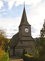
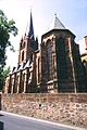
Protestant Church Erndtebrück
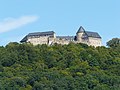
Berleburg Castle


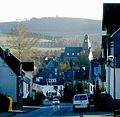
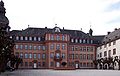
This section has a length of approx. 40 km and leads from the train station in Hilchenbach-Lützel over the Eder spring to Bad Berleburg, the city center of which is reached via a branch line from the main route. The starting point is at 547 m above sea level. NN and then rises with 2 to 4% over approx. 4.5 km to the Eder spring at 652 m above sea level. NN at. After that, there is an almost continuous gradient to the junction to Bad Berleburg at 409 m above sea level. NN . Then another 50 meters in altitude must be overcome before reaching the city. The ascent to the source can be avoided on the Oranier-Fahrrad-Route , because this remains in the valley instead of leading to the source on the Ederkopf , and after 1.4 km it meets the Ederauen-Radweg coming from the source. The path over the spring leads partly over gravel and forest paths and is therefore only recommended with a suitable mountain bike or trekking bike . When ascending the L722, the route leads past the Forsthaus Hohenroth inn and forest information center , which has changing exhibitions and a deer enclosure. After the descent from the Ederkopf next to the young Eder on the Rothaarsteig , the route runs with a slight gradient through the forest-lined Edertal approx. 7 km to Erndtebrück. Then another 14.5 km through the varied river landscape with a few small climbs (<10 meters in altitude) to Berghausen , which is 60 meters lower, and belongs to the town of Bad Berleburg. Up to this point there are still many gravel, difficult to drive sections. Until the junction to Bad Berleburg in the district "Am Stöppelsweg" it is now approx. 1.5 km and approx. 4 km further to the center of Bad Berleburg. The Kneipp health resort is home to Berleburg Castle and the “Hof Espe” agricultural museum , which shows life and work on a Wittgenstein farm from the 18th to the end of the 20th century. The entire section is accompanied by the Kreuztal – Cölbe and Erndtebrück – Bad Berleburg railway lines .
Bad Berleburg – Battenberg

Emmaus Chapel

Battenberg Castle
Old market Battenberg

Burgberg tunnel

.JPG)
.JPG)
_Burgbergstollen-DSCF3388.jpg)
This section has a length of approx. 39 km and leads from the junction to the center of Bad Berleburg through the many loops of the now narrow Edertal on an almost flat stretch to Battenberg approx. 100 meters lower. Around the village of Holzhausen you have to cover an approx. One kilometer long section on the busy country road without a cycle path. A car-free traffic route is under construction (2012). At the beginning of the section in Bad Berleburg-Raumland is the slate - mine "dip". Slate of exceptional quality was mined here from 1860 to 1923. The forge museum in Bad Berleburg-Arfeld is reached after approx. 7 km . In the forge built in the 19th century, machines and tools are driven by a water wheel. After another approx. 8 km, you leave the state of North Rhine-Westphalia and the Siegen-Wittgenstein district behind the town of Bad Berleburg-Beddelhausen and the route continues in Hesse as the Eder cycle path. Before that, the Eder was crossed twice shortly before the national border. In Hesse, the route runs on the southern bank of the Eder through the area of the city of Hatzfeld and crosses the districts of Holzhausen and Reddighausen , before continuing on the northern bank of the Eder after about 7 km. There the path leads past the Emmaus Chapel, a three-aisled late Romanesque pillar basilica from the 12th century, and after about 4 km you reach the town of Dodenau, which belongs to the town of Battenberg . The first 10 km in Hesse are asphalted on the former railway line of the Bad Berleburg – Allendorf railway line. Behind the village, the cycle route leads to the southern bank and after approx. 8 km it reaches the town of Battenberg . In Battenberg there is the former Neuburg hunting lodge, which today houses the city administration and the city museum, which focuses on the hunting trips of the Landgraves of Hessen Darmstadt, as well as the "Burgbergstollen" mine.
Battenberg – Edertal

Eder near Frankenberg
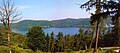
View of the Edersee near Bringhausen
View from the Edersee Wildlife Park

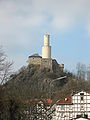
Dam wall with Waldeck Castle in the background

View from the dam of the Affolderner See

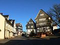
Half-timbered house in Affoldern
Felsburg in Felsberg
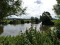
The Eder (right) flows into the Fulda.


_2006-02-25.jpg)

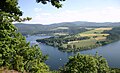
This section has a length of approx. 59 km and leads first flat and later along the Edersee hilly, with climbs up to 30 meters in altitude, in the district Hemfurth-Edersee of the municipality Edertal on the Edersee dam wall . Between the places Ederbringhausen and Schmittlotheim, the route is led over a narrow, almost natural path with a hairpin with a 20% gradient. If you have heavy luggage, you may be able to use the B252 with a hard shoulder. The route leads through the now wide, open Edertal through meadows and fields, past Allendorf , where the Viessmann heating manufacturer has its headquarters, to the town of Frankenberg, 13 km away . The half-timbered town was first mentioned in a document in 1236. Particularly worth seeing are the ten-tower town hall , the Liebfrauenkirche , and the stone house at horse market 20 as the oldest house in the city from 1240. The former Cistercian monastery St. Georgenberg now houses the district home museum. The Frankenberg (Eder) train station is connected to Marburg via the Burgwaldbahn. There is a connection to the long-distance network of the DB. If you want to change from Frankenberg to the valley of the Ohm , you can use the 40 km long Ohm-Eder cycle path from Frankenberg . After Frankenberg the valley narrows again and is lined with forest on both sides. Past the Viermünden district , where the route now runs along the railway line, after 12 km it reaches the village of Ederbringhausen . The sometimes very narrow and natural way also follows the railway line before leaving for about 6 km, the Eder crosses and next to the road on to the National Park Center Kellerwald the National Park Keller Edersee leads and Edersee. The cycle now runs along the undulating Edersee-shore and reaches after the passage of several smaller towns in a distance of about 24 km belonging to the National Park Baumkronenpfad . After another 3.5 km, the dam and the Hemfurth-Edersee stage destination are reached. The Edersee wildlife park , which is also part of the national park and which also includes a bird of prey observatory , is located in front of the village . Waldeck Castle can be clearly seen from the dam . It can be reached via the Orange Bicycle Route after approx. 6 km and 150 meters in altitude. To the south of the town are the Waldeck I u. II . Worth seeing is the underground power station Waldeck II. The two upper reservoir of the power plant performs a funicular .
Edertal – Guxhagen
This section has a length of approx. 54 km and leads mostly flat to Guxhagen where the route ends on the Fulda cycle path. About 7 km before the end of the route, another ascent to Haldorf of about 30 meters with a 7% gradient has to be overcome. The stage is accompanied by the Bad Wildungen-Wabern railway, which is operated by the Kurhessenbahn and from Wabern by the Main-Weser Railway . After the dam, the path leads down to Lake Affoldern, which serves as a lower basin for the Waldeck pumped storage power plant and as a storage basin for the Affoldern run-of-river power plant . After approx. 5 km the village of Affoldern is reached at the end of the lake. Here you can take a ride on the Eder draisine. The route then leads through the now wide Edertal and after 18 km reaches the old town of Fritzlar with its well-preserved medieval townscape. Particularly noteworthy are the Fritzlar Cathedral , the city wall with defensive towers from the 12th-14th centuries. Century, the town hall from 1109 is considered the oldest office building in Germany as well as the market with Roland's fountain and the former mint. After a further 7 km the route reaches Wabern and 8 km later the town of Felsberg. The small half-timbered old town lies below the ruins of the rock castle . The cycle path follows the course of the Eder for a further 16 km through heavily agricultural terrain before reaching the Fulda near Guxhagen. Several districts of Felsburg and the community of Edermünde are touched. Along the Fulda there is a connection to the Hessian long-distance cycle path R1 (Fulda cycle path) and the D-Route 9 (Weser-Romantic Road).
Connection to other long-distance cycle routes
- Large stretches of the Eder cycle path from the start in Lützel to the Edersee dam run together with the Oranier cycle route . It connects the cities of Diez, Nassau, Braunfels, Dillenburg, Siegen and Bad Arolsen, which have been closely linked to the royal family of the Netherlands for many centuries, over around 400 kilometers.
- The Hessian long -distance cycle path R8 (Westerwald-Taunus-Bergstraße) starts in Frankenberg and accompanies the Eder cycle path to Hatzfeld over 34 km. The R8 runs over 310 km through the Gladenbacher Bergland , the Westerwald, the Taunus , Frankfurt am Main , the Odenwald to the Bergstrasse .
- In Frankenberg-Röddenau , the Lahn-Eder cycle path turns south and connects the Eder cycle path with the Lahntal cycle path in the municipality of Lahntal for about 25 km .
- The Hessian long -distance cycle path R6 (from Waldecker Land into the Rhine Valley) meets the Eder cycle path at Affolderner See and accompanies it over 50 km to Frankenberg. The R6 begins in Diemelstadt in northern Hesse and runs with a total length of approx. 380 km to Lampertheim in southern Hesse.
- The Hessian long-distance cycle path R5 (North Hesse route Eder-Fulda-Werra) meets the Eder cycle path at the beginning of the Edersee near Vöhl-Herzhausen and accompanies it for approx. 40 km to the train station in Bad Wildungen-Wega . The R5 runs over 220 km from Willingen in the Upland along the southern shore of the Edersee , via Homberg (Efze) and Rotenburg an der Fulda to Wanfried an der Werra .
- The Hessian long -distance cycle path R4 (north-south cycle path) accompanies the Eder cycle path over 7 kilometers between Fritzlar and Wabern. The R4 begins in Hirschhorn am Neckar and runs for about 385 km from south to north through Hesse, along from Mümling , Nidda and Schwalm to Bad Karlshafen an der Weser .
- In Felsberg, the Schwalm cycle path can be reached via the regional cycle path R12 as a connecting path at a distance of 0.5 km. The Schwalm cycle path runs from Felsberg over the confluence of the Schwalm into the Eder in the Schwalmtal from north to south via Wabern, Borken , Bad Zwesten , Neuental , Schwalmstadt , Schrecksbach , Alsfeld , Schwalmtal to the source near Helpershain . From the Wabern district of Uttershausen , the Schwalm cycle path and the Hessian long-distance cycle path R4 run on the same route.
- The Eder cycle path ends on the Hessian long -distance cycle path R1 (Fulda cycle path) or D-Route 9 (Weser-Romantic Road). The R1 leads over 250 km from the heights of the Rhön along the Fulda to Bad Karlshafen on the Weser . D-Route 9 leads from the North Sea via Bremen, Kassel, Fulda and the Taubertal to Füssen in Allgäu (1,197 km).
Rail connection
The first section of the Eder cycle path between Lützel and Bad Berleburg is accompanied by the Kreuztal – Cölbe and Erndtebrück – Bad Berleburg railway lines . The regional trains of the RB93 line run every hour between Lützel and Bad Berleburg. The next rail connection is with Frankenberg (Eder) station . From here the line RB42 of the Kurhessenbahn runs every hour to Marburg . There is then no longer any train connection along the Edersee. Only in Bad Wildungen-Wega is there a connection to the Wabern – Bad Wildungen line on which the Kurhessenbahn RB39 runs every two hours. This route is accompanied by the Eder cycle path and offers three other stops in addition to Fritzlar. From Wabern there is a connection to the long-distance network of Deutsche Bahn via the Main-Weser Railway (Kassel – Frankfurt). The Regiotram (RT 9) runs between Wabern and Edermünde-Grifte with 3 further stops on the cycle path. The Guxhagen train station on the Bebra-Baunatal-Guntershausen line of the Friedrich-Wilhelms-Nordbahn-Gesellschaft is served by the RegioTram Kassel and local trains operated by the cantus Verkehrsgesellschaft . This creates a connection to the long-distance train stations in Kassel and Fulda .
- see also infobox
Landscape and culture
The Eder cycle path begins in the Rothaar Mountains in the Siegen-Wittgenstein district with the ascent to the Eder spring on the Ederkopf . The route, still referred to as the Ederauen Cycle Path, leads through the most forested region in Germany and is characterized above all by its course in untouched nature. Along the often meandering Eder meadows, fields and dense beech and spruce forests are passed. But also interesting half-timbered towns like Frankenberg and Fritzlar and quiet hamlets are on the route. After the Sauerland-Rothaargebirge nature park , the Waldecker Land is crossed to the Edersee. Here at the Edersee, certainly one of the highlights of the route, wolves, lynx, bison and red deer have found a home in the 'Wildlife Park Eder'. The cycle path continues through the Kurhessische Bergland and follows the " German Fairy Tale Route " to the confluence of the Eder and Fulda in Guxhagen.
Attractions

Ludwigsburg in Bad Berleburg

Bad Berleburg
City church St. Johannes in Hatzfeld

Catholic Church of St. Hubertus in Hatzfeld
Church of Our Lady Frankenberg

St. Georgenberg Monastery, Frankenberg

Town hall in Frankenberg

Fulling mill in Frankenberg

"Kellerwald National Park Center"
Waldeck Castle

Edersee treetop path

Funicular to the Peterskopf
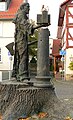
Boniface Monument Fritzlar

Four towers view of Fritzlar from the Eder


- On Ederkopf is the Eder-source and the Forest Information Center "Forsthaus Hohenrod" with changing exhibitions and a 50 ha large deer park .
- In Bad Berleburg there is
- the Berleburg Castle , one with a baroque main house from 1733 with museum on the history of the royal house to Sayn-Wittgenstein -Berleburg. The associated museum shows a collection of weapons and uniforms, porcelain and hunting rooms, as well as historical living rooms.
- the Sassenhausen school chapel : The half-timbered house built in 1703 by Mannus Riedesel was used as a chapel and as a school building;
- the Ludwigsburg , also of Mannus Riedesel built former residential building a side line of the Wittgenstein Count has extensive decorations on the ledges and corner posts;
- the listed Evangelical Church
- the Raumland slate mine is a place with a tradition of more than 400 years of slate. The dark blue natural stone "slate" was a sought-after building material for three centuries far beyond the borders of Germany. In the heyday of this branch of industry, which is important for the region, around 450 people were employed in up to 12 mines.
- the Arfeld Blacksmith Museum. In the forge built in the 19th century, machines and tools are driven by a water wheel;
- the "Hof Espe" agricultural museum documents life and work on a Wittgenstein farm over the period from the 18th to the 20th century.
- The town of Hatzfeld (Eder) is embedded in the typical low mountain range of the Upper Edertal. It has a number of interesting churches:
- The Evangelical Lutheran town church St. Johannes is a slab of half-timbered building from the 14th century.
- The Emmaus Chapel is the oldest of the three Hatzfeld churches. Built in the 12th century as a three-aisled late Romanesque pillar basilica with a defensive west tower, it was consecrated to Saint Cyriacus. It has served as a cemetery chapel since the last century.
- The Catholic Church of St. Hubertus on a rock outcrop above the Edertal, a small chapel was built in 1898 by Alfred Graf Korff called Schmissing-Kerrsenbrock, Royal Prussian chief forester in Hatzfeld. The passionate hunter named her after St. Hubertus; There is a mighty deer antler above the entrance.
- The town of Frankenberg was built in 1233/1234 by Landgrave Konrad von Thuringia , the governor of the Ludowingian Landgraves of Thuringia in their Hessian parts of the country, in order to have a counterweight to the Mainzian Battenberg (Eder) on the upper Eder . Due to its location at the intersection of two trade routes, it quickly gained economic importance. The original city was destroyed in the city fire in 1476 and only rebuilt in the 16th century. In today's city center there are many half-timbered houses. Are worth seeing among other things
- The Liebfrauenkirche , built from 1286 to 1380 , a Gothic building based on the Marburg Elisabethkirche , which burned down completely in 1476.
- The former St. Georgenberg Monastery which was built in several phases from 1249 to the 17th century. Today the former Cistercian convent houses, among other things, the district home museum.
- The 10-tower town hall from 1509 between Ober- and Untermarkt. Today's town hall is a reconstruction based on the model of the second town hall, which also burned down completely in 1476.
- The stone house at Horse Market 20 was built around 1240. Probably the oldest preserved secular building in the city survived the fire of 1476 largely undamaged.
- The cityscape, which was once closed and characterized by numerous half-timbered buildings, suffered numerous losses as part of the urban renovation carried out from 1967 onwards. Nevertheless, some notable houses from the 16th to 19th centuries, especially on the horse market, have been preserved.
- From the medieval city fortifications - in addition to small remnants of walls - the 13th century witch's tower with its 3 m thick walls was preserved.
- The Edersee is 11.8 square kilometers of water surface area of the second largest reservoir in Germany. The primary purpose of the Edertalsperre is to provide water for the Upper Weser and Mittelland Canal federal waterways . In addition, it also serves to protect against small and medium-sized floods, the generation of electrical energy and recreation. Surrounded by the Kellerwald-Edersee Nature Park , located at the Kellerwald-Edersee National Park and dominated by Waldeck Castle , the Edersee and its surroundings are an attractive and well-known leisure area. Sights at, Edersee and near the bike path are:
- "Aquapark" - water playground with miniature Edersee on a scale of 1: 200 in Hemfurth-Edersee near the Edersee dam
- Baumkronenpfad "TreeTopWalk" - 250 m long with pre-Waldlehrpfad, 800 m long "squirrel path" near Rehbach
- Kellerwald-Edersee National Park - National Park to the south of the Edersee
- Kellerwald-Edersee Nature Park - a
- Waldeck pumped storage power station - near Hemfurth am Affolderner See (access to the upper basin there by Peterskopfbahn possible)
- Waldeck Castle - near Waldeck high above the Edersee (ascent with the Waldecker Bergbahn possible; beautiful view of the Edersee)
- Barrier wall museum Edersee in Hemfurth
- Uhrenkopf - near Hemfurth-Edersee; good prospect of the Edersee dam
- Edersee wildlife park with birds of prey station - above Hemfurth-Edersee not far from the Edersee dam
- The development of the city of Fritzlar goes back to a church and monastery founded by Bonifatius . The cathedral and imperial city is considered to be the place where both the Christianization of central and northern Germany (with the fall of the Donareiche around 723 by Boniface) and the medieval German Empire (with the election of Heinrich I as King of the Germans at the Reichstag of 919) began. One of the special features of Fritzlar is the well-preserved medieval townscape with numerous half-timbered houses including the largely intact 2.5 km long town wall that surrounds the medieval town center. Particularly worth seeing are:
- The collegiate church of St. Peter , built around 1085/90 .
- The Gothic town church, arose from the former Minorite monastery church from 1244.
- the city wall with its defensive towers from the 12th to 14th centuries .
- The gray tower from the 13th century with museum.
- The town hall from 1109 is considered to be the oldest administrative building in Germany
- The market square with the Roland fountain and the former mint .
- The wedding house , built around 1580/90, is the largest half-timbered building in North Hesse. Since 1956 it has housed a museum for prehistory, folklore and city history.
- The former monastery of the Franciscans ( Minorites ) from the 13th century is now a hospital.
- The Katharinenkirche , built around 1300, is the former monastery church of the Augustinians and Ursulines .

literature
- Ederauen cycle path: from the source in the Rothaar Mountains to the Fulda; Bikeline bike tour book; Maps 1: 50,000 . 1st edition. Esterbauer publishing house, Rodingersdorf 2006, ISBN 978-3-85000-201-1 .
- Ederauen-Radweg , BVA Bielefelder Verlag, ISBN 3-87073-263-6
Web links
- Eder cycle path In: Hesse cycle route planner
- Grifte - Gudensberg and Ederauenradweg R10 In: www.bahntrassenradwege.de
- A description of the journey
- The Eder draisine on Lake Affoldern
swell
- Wikipedia pages and websites of the places along the route. Accessed August 2012
Individual evidence
- ↑ radroutenplaner.hessen.de Accessed in October 2018
Coordinates: 50 ° 58 ′ 2.4 ″ N , 8 ° 10 ′ 29.7 ″ E