Waldeck pumped storage power plant
| Pump storage power plant Waldeck I and II | |||
|---|---|---|---|
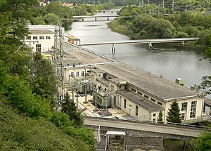
| Turbine Hall of Waldeck I with outdoor switchgear (top right) on the opposite bank of the Eder | |||
| location | |||
|
|
|||
| Coordinates | 51 ° 10 '5 " N , 9 ° 2' 44" E | ||
| country |
|
||
| place | Hemfurth-Edersee | ||
| Waters | Upper basin , Affolderner See , Eder | ||
| Data | |||
| Type | pumped storage power plant | ||
| Primary energy | water | ||
| power | 623 MW | ||
| owner | Uniper SE | ||
| operator | Uniper Kraftwerke GmbH | ||
| Project start | 1929 | ||
| Start of operations | 1931, 1974 | ||
| turbine | Francis turbine | ||
| Website | Uniper | ||
| was standing | 2019 | ||
|
Waldeck pumped storage power plant, aerial photo (2016) |
|||
The pumped storage power plant Waldeck (colloquially pumped storage plants Waldeck I and II ) consists of two pumped storage power plants , the two upper basins (also called "high storage basins ") upper basins Waldeck I and II and 2 open-air switchgears , which are located in the basement forest on Affolderner See near the Edertal district of Hemfurth-Edersee ( Location Hemfurth) in the Hessian district of Waldeck-Frankenberg ( Germany ). This is to be distinguished from the Hemfurth storage hydropower plant without pumped storage below the Edertalsperre .
The Waldeck pumped storage power plants with their upper basins, which were operated by Preussische Elektrizitäts AG until 2000 , then belonged to E.ON Kraftwerke GmbH , a subsidiary of the German E.ON AG. With the spin-off of Uniper , all hydropower plants were transferred to Uniper Kraftwerke in 2015 .
Geographical location
The Waldeck pumped storage power station and its two upper basins are located to the west or above the Affolderner See , which is about 2.5 km below the Edertalsperre between Hemfurth (southern location of Hemfurth-Edersee ) and Affoldern (both belonging to Edertal ) on the Eder . Within the limits of the Natural Park Keller Edersee they lie in the northeast part of the National Park Keller Edersee in the area of two directly adjacent elevations of the northern part of the cellar forest located Eder heights : Peter Head ( 506.6 . M above mean sea level ) in the east and Ermerod ( 539.2 m ) in the West. Both are neighbors of the Ochsenwurzelskopfs ( 542.2 m ) in the north and Dicken Kopfs ( 603.7 m ) in the south or represent their foothills.
Pump storage plants Waldeck I and II
Purpose of the Waldeck pumped storage power plant
The pumped storage Waldeck were built to cope with previously uphill pumped water with the aid of a steep slope through pipelines (referred to here as "down pipes" or "pressure pipes") falls and then through water turbines flows electricity to produce. This happens in Waldeck I and Waldeck II .
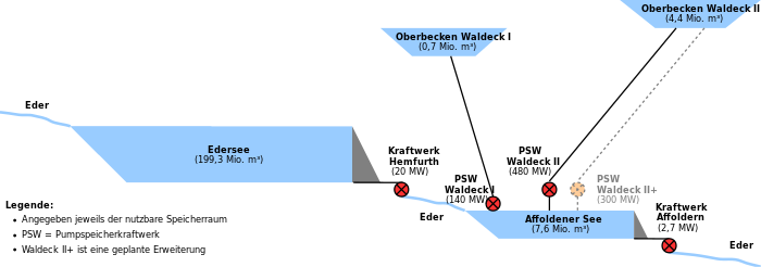
To this end, in the two pumped storage power plants as peak load power plants act pumped water from the Eder and from the Affolderner lake over pressure pipes in two upper reservoir to, hinabzustürzen in peak loads by large downpipes again to make it with the lying deep down turbines and generators of Power plants can deliver up to 600 megawatts (MW) of electrical power. This is one of the reasons why the water level in Affolderner See is quite different.
Both pumped storage plants use Affolderner See, which also serves as a flood retention basin , as a lower basin . A run-of-river power plant was also integrated into the barrage of the lake .
Waldeck I.
| Upper basin Waldeck I | |||||||||||
|---|---|---|---|---|---|---|---|---|---|---|---|
| View from the Peterskopf viewing platform at Upper Basin II (on the Ermerod ) approximately to the southeast to the empty Upper Basin I (with inlet structure; on the Peterskopf) of the Waldeck pumped storage plant with the mountains of the Kellerwald in the background | |||||||||||
|
|||||||||||
| Coordinates | 51 ° 9 ′ 41 ″ N , 9 ° 1 ′ 55 ″ E | ||||||||||
| Data on the structure | |||||||||||
| Construction time: | 1929-1933 | ||||||||||
| Height above the river bed : | 23 m | ||||||||||
| Power plant output: | 145 MW | ||||||||||
| Data on the reservoir | |||||||||||
| Altitude (at congestion destination ) | 506.6 m above sea level NHN | ||||||||||
| Storage space | 0,734,000 m³ | ||||||||||
| Particularities: |
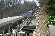
The Peterskopfbahn runs along the pipelines leading from the upper basin to the power plant |
||||||||||
The Waldeck I pumped storage plant (called Waldeck I and PSW WA1 for short ) is located at the foot of the Peterskopf , which is close to the influence of the Eder in the Affolderner See , and the associated upper basin Waldeck I ( upper basin I ) lies on the hilltop that has been removed or hollowed for the basin .
The power station and upper basin were built between 1929 and 1933. Commercial power generation began in 1931, and construction work ended in 1933.
In the north, east and south of the Beckenumfassung's upper reservoir I a gravity dam made of reinforced concrete , its western side towards the upper reservoir II is bounded by a natural but artificially sealed embankment.
Through the or from the inlet construction of the approximately 23 m deep cast concrete trough of the upper reservoir I which to 55,000 m² base 0734000 m³ can absorb water and its water level at 506.6 m is high, the water falls on the eastern side of the mountain which is a maximum 45.5% gradient, along the funicular route of the Peterskopfbahn through pressure pipes with an inner diameter of 2.20 to 2.50 m down into the turbine hall of Waldeck I , which is located at the foot of the mountain in the Edertal , the hall floor is 204.4 m high, which corresponds to a full damming of the Affolderner See ( 204 m ) just above its water surface. Starting from the bottom outlet of the upper basin, the water overcomes a total of around 280 m difference in altitude in order to generate electricity within turbines integrated in the concrete base. The water flows from the power station building through a short connecting channel to the reservoir.

The original four Francis turbines from Waldeck I had a combined installed capacity of 140 MW. Because these turbine sets were in need of renewal after 74 years of operation, a new power plant building with a new, vertical pump turbine was built in April 2006. This single turbine has a nominal output of 73 MW. In addition, two old turbines have been modernized and are still being used to provide a minute reserve . The other two turbines were shut down so that a total output of 145 MW can now be achieved with three instead of four turbines. The new power plant was built between the training workshop and the existing power house. The new facility was inaugurated on April 20, 2010.
The geographical coordinates of the standing at the foot of Peter head building of the pumped storage power plant Waldeck I are (for the coordinates of the upper reservoir Waldeck I see in right standing box): 51 ° 9 '59.6 " N , 9 ° 2' 46.7" O .
Waldeck II
| Upper basin Waldeck II | |||||||||||
|---|---|---|---|---|---|---|---|---|---|---|---|
| The upper reservoir Waldeck II (large) with mobile - radio tower on the observation deck Peterskopf (left) and Waldeck I (small; 2016) | |||||||||||
|
|||||||||||
| Coordinates | 51 ° 9 ′ 30 ″ N , 9 ° 1 ′ 30 ″ E | ||||||||||
| Data on the structure | |||||||||||
| Construction time: | 1970-1973 | ||||||||||
| Height above foundation level : | 20 to 56.50 m | ||||||||||
| Height above the river bed : | 29 m | ||||||||||
| Height of the structure crown: | 541.5 m above sea level NHN | ||||||||||
| Building volume: | 3,065,000 m³ | ||||||||||
| Crown length: | 2.886 km | ||||||||||
| Crown width: | 4.5 m | ||||||||||
| Slope slope on the air side : | 1: 1.5 and 1: 1.75 | ||||||||||
| Slope slope on the water side : | 1: 1.75 | ||||||||||
| Power plant output: | 480 MW | ||||||||||
| Data on the reservoir | |||||||||||
| Altitude (at congestion destination ) | 540.7 m above sea level NHN | ||||||||||
| Water surface | 30 ha | ||||||||||
| Storage space | 4.71 million m³ | ||||||||||
| Total storage space : | 5.1 million m³ | ||||||||||
| Particularities: |
Water flows through an underground pipeline from the upper basin into a cavern power station |
||||||||||
The pumped storage plant Waldeck II (short Waldeck II and PSW WA2 called) is located in a man-made cavern of close to the influence of the Eder in the Affolderner lake situated Peter head , the associated upper reservoir Waldeck II ( upper reservoir II ) is on the worn for the pelvis or . excavated crest of its western neighbor mountain Ermerod.
The power plant was built from 1969 to 1974 and the upper basin from 1970 to 1973, around four decades after the construction of the Waldeck I and upper basin I pumped storage plants .
Through or from the bottom outlet of Upper Basin II , which can hold 4.74 million m³ of water and whose storage target is 540.7 m high - that is 34.2 m higher than the significantly smaller Upper Basin I - the water falls within the Peterskopfs down through a pressure pipe with a maximum internal diameter of 5.75 m into the cavern of the turbine hall of Waldeck II located in the mountain , the hall floor of which is 148.5 m high. Because of the cave location, this is called a cavern power station . Starting from the bottom outlet of the upper basin, the water overcomes a total of almost 360 m difference in altitude in order to generate electricity within turbines integrated in the concrete base. The hall is about 100 m long, 54 m high and 33 m wide.
From this cavern turbine hall, it rushes long within the Peter head by a several hundred meters, underground tunnels with 7.5 m diameter past an in-Berg water lock comprising the produced during the closing or opening of the pipe of a hydropower plant pressure surge in the pipeline by Auspendelmöglichkeit reduced in the moated castle cave, on to the Affolderner See. In doing so, it is - driven only by the force of pushing water masses - pushed up about 55 m up to this reservoir, the water surface of which is 204.5 m high when fully dammed .
The bottom outlet of the upper basin II consists of two inlet structures built directly next to one another on the basin floor with a total of four inlet gates and respective protective grids. The water flowing out of the basin through the building on the left heads for Waldeck II, while the one on the right was created during the construction of the basin for the planned but never realized Waldeck III pumped storage plant .
Waldeck II has two sets of machines, each with a Francis turbine with an installed capacity of 240 MW each, a pump with the same output and a motor generator . As a result of extensive overhaul work and the replacement of the turbine runners, the output of the machines rose from 220 to 240 MW each. Waldeck II has a total installed capacity of 480 MW.
The dam crown of Upper Basin II is 541.5 m high. The height of the embankment above the foundation is not generally applicable, as the terrain is very irregular and the foundation base is inclined. Depending on the reference point, specifications between 20 and 56.5 m are possible.
At the edge of Upper Basin II is the Peterskopf viewing platform with an attached transmission tower for mobile communications .
The geographic coordinates of located in Peter head cavern building of the pumped storage power plant Waldeck II are about (for the coordinates of the upper reservoir Waldeck II see in right standing box): 51 ° 9 '53 " N , 9 ° 2' 20" O .
Outdoor switchgear

Beyond and to the east of Eder are 2 free air switchgear , by a leading over the river power cable bridge (Waldeck I; 110 kV) and further north the river spanning high-voltage lines (for Waldeck II; 380 kV) with the pumped storage power plants is connected .
The geographical coordinates of the switchyard located in Eder are: 51 ° 10 '0 " N , 9 ° 3' 0 ' O .
The Waldeck I power plant is connected to the Avacon 110 kV high-voltage network via the open-air switchgear, and the Waldeck II power plant to the Tennet TSO's 380 kV high-voltage network.
Power plant expansion II +
E.ON has plans to expand Waldeck II . Approval for this was granted in 2011.
A pump turbine with a capacity of 300 MW is to be built in another cavern, that of Waldeck II + , and connected to Upper Basin II and the Affoldener See by pipes . Investments of 250 million euros were planned for the project, and commissioning should be in 2016. This expansion - together with the modernization of the turbines of Waldeck II - would increase the output of the Waldeck pump storage group to 920 MW. The plans to build a new turbine were put on hold, in February 2014 only planning to increase the storage volume was resumed. In 2014 the top of the dam was raised, increasing the storage volume and thus the energy that can be stored in Upper Basin II by 11%.
tourism
Peterskopfbahn
You can take the Peterskopfbahn from Hemfurth or Affolderner See to the two upper basins on the Peterskopf and Ermerod.
Peterskopf viewing platform
At the edge of Upper Basin II there is the Peterskopf viewing platform (see the Tourism and Facilities section of the Peterskopf article) at a height of 540.58 m . From there the view falls to the Edersee , the Affolderner See , the Kellerwald and the Hohen Habichtswald .
Individual evidence
- ↑ Appendix - Generation Assets. Capital Market Story. Uniper, April 26, 2016, accessed on February 12, 2017 .
- ↑ a b c d power plant list. Federal Network Agency , March 7, 2019, accessed on September 17, 2019 .
- ↑ a b c d Map services of the Federal Agency for Nature Conservation ( information )
- ↑ a b Altitude of the upper edge of upper basin II according to the label on the plaque there
- ↑ Article E.ON plans to expand the Waldeck 2 pumped storage power plant ( memento from March 4, 2016 in the Internet Archive ) from December 23, 2010, on eon.com, last accessed on September 5, 2013
- ↑ Article E.ON receives approval for the expansion of the Waldeck 2 pumped storage power plant ( memento of July 8, 2012 in the Internet Archive ) from December 21, 2011, on eon.com, accessed on September 5, 2013
- ↑ Article Edersee: New power plant will not be built for the time being , from October 5, 2012, on hna.de.
- ↑ Article Dammkrone auf dem Peterskopf is increased , from February 27, 2014, on hna.de.
- ↑ Altitude of the Peterskopf viewing platform as indicated by the plaque there
See also
literature
- Peter Franke and Wolfgang Frey: Dams in the Federal Republic of Germany , Berlin, 1987, ISBN 3-926520-00-0 .
- Ulrich Klein: The Edertalsperre and the beginning of the electricity supply in Northern Hesse 1914–1922 , in: Hessische Heimat 61 (2011), pp. 69–76.
- Rolf-Günter Köhn and Martin Rau: Modernization of the pumped storage power station Waldeck I - renovation of the upper basin , WasserWirtschaft, 4/2010, pages 123–125.
Web links
- Uniper homepage with information about the power plant
- Graphics of the planned new plant and the existing power plants on eon.com (PDF file, 1.42 MB)


