Ederbringhausen
|
Ederbringhausen
Vöhl municipality
Coordinates: 51 ° 7 ′ 47 " N , 8 ° 51 ′ 56" E
|
|
|---|---|
| Height : | 256 m above sea level NHN |
| Area : | 12.8 km² |
| Residents : | 299 (2014) |
| Population density : | 23 inhabitants / km² |
| Incorporation : | December 31, 1971 |
| Incorporated into: | Hessenstein |
| Postal code : | 34516 |
| Area code : | 06454 |
|
Location of Ederbringhausen in Vöhl
|
|
Ederbringhausen is a small district of the municipality of Vöhl in the north Hessian district of Waldeck-Frankenberg .
Geographical location
Ederbringhausen lies in the transition area between the natural sub-units of Waldstruth in the west and Niederkellerwald in the east, around 16 km south of the district town of Korbach . Directly at the village, which is surrounded by deciduous and coniferous forests, the Sasselbach flows into the Orke , which flows into the Eder a little southeast of the village . The Kellerwald-Edersee Nature Park extends directly to the east of the Eder with the Kellerwald-Edersee National Park . The barrier wall of the Edersee is about 15 km (depending on the beeline ) to the northeast.
history
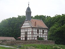
The first mention is in 1240, formerly belonging to the Itter rule . In addition to the Keseburg , which was built around 1144 and was owned by the Bailiffs von Keseberg (Caseberch), to the east of the Eder is the Hessenstein Castle , which was built from 1328 to 1342 and currently serves as a conference center. The half-timbered church built in 1801 by Johannes Jesberg from Röddenau was demolished in 1975 and rebuilt in the Hessenpark open-air museum near Neu-Anspach.
Territorial reform
On December 31, 1971, in the course of the regional reform in Hesse, the previously independent communities of Ederbringhausen, Buchenberg , Harbshausen , Kirchlotheim , Niederorke , Oberorke and Schmittlotheim were dissolved and incorporated into the new community of Hessenstein.
On 1 January 1974, the municipality Hessenstein was powerful state law with Ittertal (consisting of the former municipalities Dorfitter , Herzhausen and Thalitter ), Marie Hagen , Obernburg and Vohl for new large village Vöhl together . Local districts were established for all formerly independent communities .
Rail connection
The Warburg – Sarnau railway was opened in 1900 with a train station in Ederbringhausen, but was shut down in 1987. For years it was called for a restart, and trains have stopped here again since September 11, 2015. The route connects Brilon and Korbach via Ederbringhausen with Frankenberg (Eder) and Marburg (Lahn) ; in Korbach there is a connection to Kassel .
Attractions
Trivia
The former village church is now in the Hessenpark.
Web links
- The place on the website of the municipality of Vöhl
- Ederbringhausen, Waldeck-Frankenberg district. Historical local dictionary for Hesse (as of December 5, 2014). In: Landesgeschichtliches Informationssystem Hessen (LAGIS). Hessian State Office for Historical Cultural Studies (HLGL), accessed on March 18, 2015 .
- Literature about Ederbringhausen in the Hessian Bibliography
Individual evidence
- ↑ a b The place on the website of the municipality of Vöhl , accessed in April 2016.
- ^ History of the half-timbered church ( Memento from June 8, 2008 in the Internet Archive )
- ↑ a b Federal Statistical Office (ed.): Historical municipality register for the Federal Republic of Germany. Name, border and key number changes in municipalities, counties and administrative districts from May 27, 1970 to December 31, 1982 . W. Kohlhammer, Stuttgart / Mainz 1983, ISBN 3-17-003263-1 , p. 390-391 .
- ↑ Law on the reorganization of the districts of Frankenberg and Waldeck (GVBl. II 330-23) of October 4, 1973 . In: The Hessian Minister of the Interior (ed.): Law and Ordinance Gazette for the State of Hesse . 1973 No. 25 , p. 359 , § 6 ( online at the information system of the Hessian state parliament [PDF; 2,3 MB ]).


