Village knight
|
Village knight
Vöhl municipality
Coordinates: 51 ° 14 ′ 12 " N , 8 ° 53 ′ 27" E
|
|
|---|---|
| Height : | 322 m above sea level NHN |
| Area : | 4.28 km² |
| Residents : | 849 (2014) |
| Population density : | 198 inhabitants / km² |
| Incorporation : | 1st February 1971 |
| Incorporated into: | Ittertal |
| Postal code : | 34516 |
| Area code : | 05631 |
|
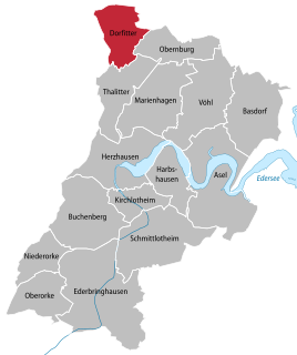
Location of Dorfitter in Vöhl
|
|
|
View from Dorfitter (2012)
|
|
Dorfitter is a district in the large municipality of Vöhl in the district of Waldeck-Frankenberg in northern Hesse .
Geographical location
Dorfitter is located in the Ittergau on the Itter , a stream coming from the west towards Ober- and Nieder-Ense , which flows into the nearby Edersee . Immediately above or to the west of the village, the Marbeck flows into the Itter; The Kuhbach joins a little below the village . Through the village, which is about 330 to 370 m above sea level. NN , the federal highway 252 runs in the section between Korbach (north) and Herzhausen (south).
history
The first mention of Itter comes from the year 1126. Initially, the place was called "Dorpytere" in the deed of the Lords of Löwenstein (1251), from 1329 "Dorfyttere" is handed down.
The large dumps and the colliery still bear witness to the intensive copper mining that lasted from the sinking of the first shaft by Ludwig Balthasar Müller in 1709/10 to 1868 . Instead of the Bartholomäus chapel from the 13th century, today's Protestant church was built using medieval components, including an altarpiece made of late Gothic and Baroque components and a crucifix from the 14th century.
On February 1, 1971, the municipalities of Dorfitter, Thalitter and Herzhausen merged to form the new municipality of Ittertal as part of the regional reform in Hesse . On 1 January 1974, the municipality Ittertal was powerful state law with Hessenstein (consisting of the former municipalities Buchenberg , Ederbringhausen , Harbshausen , Kirchlotheim , Niederorke , Oberorke and Schmittlotheim ), Marie Hagen , Obernburg and Vohl for new large village Vöhl together . Local districts were established for all formerly independent communities .
Personalities
- Helge Timmerberg (* 1952), German journalist and author
- Burkhard Sude (* 1957), German volleyball player
literature
- Thomas Gothe: On the history of the Itter rule and the mining of the Ittertal in Northern Hesse. In: Yearbook of the Hessian Church History Association , 61, 2010, pp. 237–250.
- Götz J. Pfeiffer: The retable of the evangelical Bartholomäuskirche to Dorfitter. On the artists and history of a late Gothic-Baroque altarpiece , in: Yearbook of the Hessian Church History Association , 61, 2010, pp. 221–236.
- Literature on Dorfitter in the Hessian Bibliography
Web links
- Dorfitter district. In: Website of the municipality of Vöhl.
- Dorfitter, Waldeck-Frankenberg district. Historical local dictionary for Hessen. In: Landesgeschichtliches Informationssystem Hessen (LAGIS).
Individual evidence
- ↑ a b The place on the website of the municipality of Vöhl , accessed in April 2016.
- ↑ Law on the reorganization of the districts of Frankenberg and Waldeck (GVBl. II 330-23) of October 4, 1973 . In: The Hessian Minister of the Interior (ed.): Law and Ordinance Gazette for the State of Hesse . 1973 No. 25 , p. 359 , § 6 ( online at the information system of the Hessian state parliament [PDF; 2,3 MB ]).
- ^ Federal Statistical Office (ed.): Historical municipality directory for the Federal Republic of Germany. Name, border and key number changes in municipalities, counties and administrative districts from May 27, 1970 to December 31, 1982 . W. Kohlhammer, Stuttgart / Mainz 1983, ISBN 3-17-003263-1 , p. 390-391 .


