Buchenberg (Vöhl)
|
Buchenberg
Vöhl municipality
Coordinates: 51 ° 9 ′ 29 ″ N , 8 ° 52 ′ 20 ″ E
|
|
|---|---|
| Height : | 376 m above sea level NHN |
| Area : | 8.08 km² |
| Residents : | 447 (2014) |
| Population density : | 55 inhabitants / km² |
| Incorporation : | December 31, 1971 |
| Incorporated into: | Hessenstein |
| Postal code : | 34516 |
| Area code : | 05635 |
|
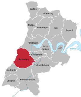
Location of Buchenberg in Vöhl
|
|
Buchenberg is a district of the municipality of Vöhl in the north Hessian district of Waldeck-Frankenberg , which is not far to the east of Waldeck Switzerland .
Geographical location
Buchenberg lies in the transition area between the natural sub-units of Waldstruth in the west and Niederkellerwald in the east, in the northeast of Sachsenberger Leimestruth , which is part of Waldstruth , just under 13 km south of the district town of Korbach . The barrier wall of the Edersee stands about 13.5 km (each as the crow flies ) east-northeast. The Sasselbach flows west around the village ; its longest tributary rises in the village and flows as a stream through its eastern locations.
history
In 1293 under the name "Buchmar" the place was mentioned for the first time in a document from the monastery Haina . Buchenberg belonged to the Itter rule . This is confirmed in an Iterian document dated June 7, 1305. Buchenberg later belonged to the Itter office or to the district of Vöhl ( Landgraviate or Grand Duchy of Hessen-Darmstadt ). The residents are nicknamed "Röjjelinge", whose origin has not yet been clarified.
On December 31, 1971, in the course of the regional reform in Hesse, the previously independent communities of Buchenberg, Ederbringhausen , Harbshausen , Kirchlotheim , Niederorke , Oberorke and Schmittlotheim were dissolved and incorporated into the new community of Hessenstein .
On 1 January 1974, the municipality Hessenstein was powerful state law with Ittertal (consisting of the former municipalities Dorfitter , Herzhausen and Thalitter ), Marie Hagen , Obernburg and Vohl for new large village Vöhl together . Local districts were established for all formerly independent communities .
Individual evidence
- ↑ a b The place on the website of the municipality of Vöhl , accessed in April 2016.
- ↑ a b Federal Statistical Office (ed.): Historical municipality register for the Federal Republic of Germany. Name, border and key number changes in municipalities, counties and administrative districts from May 27, 1970 to December 31, 1982 . W. Kohlhammer, Stuttgart / Mainz 1983, ISBN 3-17-003263-1 , p. 390-391 .
- ↑ Law on the reorganization of the districts of Frankenberg and Waldeck (GVBl. II 330-23) of October 4, 1973 . In: The Hessian Minister of the Interior (ed.): Law and Ordinance Gazette for the State of Hesse . 1973 No. 25 , p. 359 , § 6 ( online at the information system of the Hessian state parliament [PDF; 2,3 MB ]).
Web links
- The place on the website of the municipality of Vöhl
- Buchenberg, Waldeck-Frankenberg district. Historical local dictionary for Hessen. In: Landesgeschichtliches Informationssystem Hessen (LAGIS).
- Literature about Buchenberg in the Hessian Bibliography
- Website of the association "Active Buchenberg" about the place

