Kirchlotheim
|
Kirchlotheim
Vöhl municipality
Coordinates: 51 ° 10 ′ 7 ″ N , 8 ° 53 ′ 44 ″ E
|
|
|---|---|
| Height : | 252 m above sea level NHN |
| Area : | 2.8 km² |
| Residents : | 106 (2014) |
| Population density : | 38 inhabitants / km² |
| Incorporation : | December 31, 1971 |
| Incorporated into: | Hessenstein |
| Postal code : | 34516 |
| Area code : | 05635 |
|
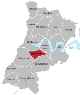
Location of Kirchlotheim in Vöhl
|
|
Kirchlotheim is a district of the municipality of Vöhl in the northern Hessian district of Waldeck-Frankenberg .
Geographical location
Kirchlotheim is located about five kilometers (as the crow flies ) southwest of Vöhl, the core town of the municipality, in the valley of the Eder (at river kilometer 72.6) shortly before its influence in the western end of the Edersee . The Kellerwald-Edersee National Park , which is framed by the Kellerwald-Edersee Nature Park , borders the village immediately to the east. The "National Park Center Kellerwald" is close to the village. Federal road 252 leads through the Edertal directly west past the village .
history
Barrows from the Bronze Age are evidence of early settlement in the Kirchlotheim area . The place was located in the former border area between Saxony and Franconia , of which remains of old fortifications from the time between the 8th and 10th centuries, the near Burg on the oven and the Mückenburg testify. In 1240, Cistercian monks reported that a "monk's farm " was founded to the left of the Eder . For the year 1265 the building of a separate church in the "Brückengrund" is known.
The village of Kirchlotheim was first mentioned in 1233, and it was first mentioned in documents in 1359. The field name "Goldacker" still reminds of the gold search carried out along the Eder in the 17th century . Presumably Johann Heinrich Tischbein the Younger (1742–1808) from the Tischbein family of artists is said to have spent his childhood here until he was 12 years old.
On December 31, 1971, in the course of the regional reform in Hesse, the previously independent communities of Kirchlotheim, Buchenberg , Ederbringhausen , Harbshausen , Niederorke , Oberorke and Schmittlotheim were dissolved and incorporated into the new community of Hessenstein.
On 1 January 1974, the municipality Hessenstein was powerful state law with Ittertal (consisting of the former municipalities Dorfitter , Herzhausen and Thalitter ), Marie Hagen , Obernburg and Vohl for new large village Vöhl together . Local districts were established for all formerly independent communities .
Personalities
- Wilhelm Unger (1775–1855), artist
Individual evidence
- ↑ a b The place on the website of the municipality of Vöhl , accessed in April 2016.
- ↑ a b Federal Statistical Office (ed.): Historical municipality register for the Federal Republic of Germany. Name, border and key number changes in municipalities, counties and administrative districts from May 27, 1970 to December 31, 1982 . W. Kohlhammer, Stuttgart / Mainz 1983, ISBN 3-17-003263-1 , p. 390-391 .
- ↑ Law on the reorganization of the districts of Frankenberg and Waldeck (GVBl. II 330-23) of October 4, 1973 . In: The Hessian Minister of the Interior (ed.): Law and Ordinance Gazette for the State of Hesse . 1973 No. 25 , p. 359 , § 6 ( online at the information system of the Hessian state parliament [PDF; 2,3 MB ]).
Web links
- District Kirchlotheim In: Website of the municipality Vöhl.
- Kirchlotheim, Waldeck-Frankenberg district. Historical local dictionary for Hessen. In: Landesgeschichtliches Informationssystem Hessen (LAGIS).
- Literature about Kirchlotheim in the Hessian Bibliography


