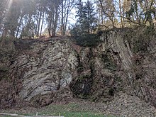
Beddelhausen silica slate quarry
The Beddelhausen silica slate quarry is one of the most important geotopes in the eastern Rhenish Slate Mountains . In the small quarry not far from the bridge over the Eder near Beddelhausen, there are heavily folded sub-carbon silica slates or radiolarites .
location
The geotope is located in the old municipal quarry south of the Beddelhausen opposite the old Eder bridge. In the now disused quarry, silica slate was formerly used for local use, e.g. B. dismantled as road and road gravel.
geology
The thin, up to 10 cm thick, black to greenish-gray layers of pebble slate are separated from one another by thin layers of clay that arose from weathered volcanic ash that erupted and sedimented during the Lower Carboniferous . The hard, brittle chert and radiolarites are primarily made numerous microscopically small unicellular organisms with a silica skeleton, the radiolarians constructed. Radiolarians lived in the deeper ocean areas than plankton .
The silica schists were formed about 330 to 340 million years ago as offshore deposits in a deep sea basin that covered large parts of what is now northern Central Europe. At the bottom of the sea fine-grained clay mud, in which the dead radiolarians were embedded, collected. Due to the increasing load due to the subsequent sedimentation of further sediment layers, the water was gradually pressed out of the clay sludge and the rock was solidified diagenetically .
At the end of the Carboniferous , about 300 million years ago, the Rhenish Slate Mountains began to rise up during the Variscan mountain formation . The layers that were previously deposited horizontally were adjusted, unfolded and in some cases pushed one on top of the other . In the Beddelhausen quarry, a sequence of intensely tectonically stressed rocks with some faults is exposed.
Due to its regional geological importance with regard to the stratigraphic structure of the Lower Carboniferous in the eastern Rhenish Slate Mountains and the unusual fold structures, the quarry was placed under nature protection. In 2006 the quarry was included in the list of 77 national geotopes in Germany.
Above the outcrop is a newly uncovered, small quarry, in which younger layers of the fossil-bearing siliceous transition layers of the Lower Carboniferous, which has also been placed under nature protection, are exposed .
literature
- Matthias Piecha: Explanations of the geological map of North Rhine-Westphalia 1: 25,000, sheet 4916 Bad Berleburg , Krefeld 2004
Individual evidence
- ↑ a b Matthias Piecha: Fossil seabed in folds - The Kieselschiefer in Wittgensteiner Land . In: Ernst-Rüdiger Look, Ludger Feldmann (Ed.): Fascination Geology. The important geotopes of Germany , E. Schweizerbart'sche Verlagsbuchhandlung, Stuttgart 2006, ISBN 3-510-65219-3 , pp. 62f.
- ^ Geological Service NRW (Ed.): Geotopes in North Rhine-Westphalia - Evidence of Earth History , Krefeld 2008, ISBN 978-3-86029-972-2 , p. 21
- ↑ Bad Berleburg landscape plan, page 86 , accessed on February 2, 2016
- ↑ One of the most spectacular geotopes in Germany. In: WAZ. Retrieved February 3, 2016 .
Coordinates: 50 ° 59 ′ 53.5 ″ N , 8 ° 29 ′ 14 ″ E
