Flours
|
Flours
municipality Edertal
Coordinates: 51 ° 9 ′ 52 ″ N , 9 ° 6 ′ 21 ″ E
|
|
|---|---|
| Height : | 198 m above sea level NHN |
| Area : | 5.98 km² |
| Residents : | 499 (Dec 15, 2015) |
| Population density : | 83 inhabitants / km² |
| Incorporation : | December 31, 1971 |
| Postal code : | 34549 |
|
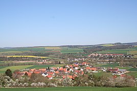
Edertal-Mehlen seen from the south. Flour in the foreground, Lieschensruh in the background (north of the Eder )
|
|
Mehlen is a district of the municipality of Edertal in the Waldeck-Frankenberg district in northern Hesse .
Geographical location
The street village of Mehlen is located on the northeast edge of the Kellerwald-Edersee Nature Park and east of the Kellerwald-Edersee National Park in the center of the Edertal municipality on both sides of the Eder tributary to the Fulda . The place consists of the core town of Mehlen, located south of the Eder, and the "Lieschensruh" housing estate north of the river. The Netze flows into the Eder immediately south of Lieschensruh . About 800 m northwest of Lieschensruh is the Buhlener Viaduct , which crosses the networks and the federal highway 485 .
history
The village emerged around the ninth century. The place "Mehilina" was first mentioned in a document in 850, when a Gozmar donated his possessions in the seven villages Affoldern , Buhlen , Gleichen, Haine , Mehlen, Schreufa and Viermünden to the Fulda monastery in the Frankenberg - Waldeck - Wildungen area .
In the past, people lived from agriculture and cattle breeding. Today agriculture is no longer of great importance. Until a few years ago, dredging for gravel and sand east of Mehlen, and several dredging ponds were created . Some of these ponds are now designated as nature reserves . Crafts and tourism determine the infrastructure today.
The village belonged to the county or the principality of Waldeck until 1919 .
The population of the core town is now exceeded by that of the Lieschensruh district, which only emerged in the second half of the 20th century. The town's church was built in 1798, the bridge over the Eder in 1896, as part of the construction of the then state road Mehlen-Lieschensruh-Buhlen (today part of the federal road 485 ).
On December 31, 1971, flour was incorporated into the community of Edertal.
Clubs and events
At clubs there is the “SV Edergold Mehlen 1970 e. V. “and the voluntary fire brigade Mehlen. A choral society is being rebuilt. The fair , which takes place every year at the end of June on the fairground on the Eder, is well known in the entire North Hesse region .
Sons and daughters of the place
- Karl Hartwig (1881–1958), German MP
literature
- Otto Mette: Flours . Arolsen: Waldeckischer Geschichtsverein 1987 (= Waldeckische Ortssippenbücher 31); Covered period 1550–1985, 920 families
Web links
- Flour on the website of the municipality of Edertal
- Mehlen, Waldeck-Frankenberg district. Historical local dictionary for Hessen. In: Landesgeschichtliches Informationssystem Hessen (LAGIS).
- Literature on flour in the Hessian Bibliography
Individual references, footnotes
- ^ Mehlen, Waldeck-Frankenberg district. Historical local dictionary for Hessen. (As of February 17, 2014). In: Landesgeschichtliches Informationssystem Hessen (LAGIS).
- ↑ Population figures on the website of the municipality of Edertal , accessed in February 2016.
- ↑ It is believed that he was an ancestor of the Counts of Reichenbach and the Counts of Ziegenhain .
- ^ Federal Statistical Office (ed.): Historical municipality directory for the Federal Republic of Germany. Name, border and key number changes in municipalities, counties and administrative districts from May 27, 1970 to December 31, 1982 . W. Kohlhammer GmbH, Stuttgart / Mainz 1983, ISBN 3-17-003263-1 , p. 408 .


