Bergheim (Edertal)
|
Bergheim
municipality Edertal
Coordinates: 51 ° 10 ′ 4 ″ N , 9 ° 8 ′ 13 ″ E
|
|
|---|---|
| Height : | 207 m above sea level NHN |
| Area : | 10.16 km² |
| Residents : | 940 (Dec 15, 2015) |
| Population density : | 93 inhabitants / km² |
| Incorporation : | July 1, 1971 |
| Postal code : | 34549 |
| Area code : | 05623 |
|
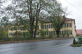
Bergheim Castle
|
|
Bergheim is the largest district of the community Edertal in the north Hessian district Waldeck-Frankenberg .
Together with the neighboring Giflitz , seat of the municipal administration, Bergheim forms the community center, which is therefore shown as the basic center in the regional plan.
Geographical location
Bergheim is located in the Wegaer Ederaue a little north of the mouth of the Böhner Bach and west of the mouth of the Mölcherbach in the Eder , which flows into the Fulda from the Rothaargebirge . About 3.5 km to the north is Böhne , about 3 km to the north-northeast of Königshagen and just under 4 km to the southeast of Wellen . About 1 km south of the Eder is Giflitz . About 2 km west-northwest of Bergheim is Mehlen with the locality of Lieschensruh . The Edersee reservoir is located even further to the west . The next larger cities are Bad Wildungen (south) and Fritzlar (east).
history
The place
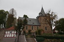
Bergheim consists of the lower village and the upper village. The new development area with many modern buildings is located in the upper village. The lower village is home to the local industry, a community hall, which, since 1035, first documented Reformation Lutheran St. Martin's Church, a former fortified church , on the Kirchberg, as well as by para-alloy counts of Waldeck-Bergheim built castle Bergheim. In front of the church there is a memorial stone for the dead of the Second World War and a "glass ball", which stands as a feature of the village (hence the Bergheimer nickname "Glaskugelgucker"). Due to frequent theft of the glass ball, it was exchanged for a plastic ball. The original bridge over the Eder between Bergheim and Giflitz was built in 1889/90 by the construction department of the then Waldeck'schen Kreis der Eder and destroyed in the Second World War by the tidal wave after the Edertalsperre was damaged. The current bridge was built in the 1950s.
Territorial reform
On July 1, 1971, the municipality of Edertal was re-established as part of the regional reform in Hesse through the voluntary merger of the previously independent municipalities of Bergheim and Giflitz.
Bergheim Castle
The Bergheim Castle was 1692 instead of a small medieval castle seat for Count Christian Ludwig of Waldeck built. He handed over the castle with the villages of Bergheim, Wellen and Königshagen as Paragium to his son from his second marriage, Josias , who founded the count's branch line Waldeck-Bergheim , which existed until 1938 . From 1785 to 1786, the Kassel builder Simon Louis du Ry extended the palace in the early Classicist style for Count Josias II von Waldeck-Bergheim.
Gold washing on the Eder
Wilhelm Ludwig von Eschwege founded the "Hessisch-Waldeckische Compagnie for the extraction of gold from the Edder river" in Kassel in 1832. Prince Elector and co-regent Friedrich Wilhelm von Hessen-Kassel and Prince Georg II. Heinrich von Waldeck took part as shareholders and "highest protectors", and a number of Hessian and Waldeck nobles as well as respected citizens of the region became shareholders. The company built Europe's largest gold panning facility at the time on the Eder near Bergheim, but the expensive company was a flop because there were no gold nuggets , only the finest gold leaves, and went into liquidation in May 1835 .
Former Jewish community in Bergheim
The Bergheim Jewish community existed from the 18th century until after the First World War . The Jewish families from Affoldern , Bergheim, Kleinern , Mehlen and Wellen belonged to it . According to previous knowledge, the community consisted of about ten families. There was a synagogue and a religious school. It is believed that there was also a ritual bath ( mikveh ), which was not in the synagogue. A Jewish cemetery was also established in Bergheim in the 19th century. The Jewish residents of Bergheim, Wellen , Mehlen, Affoldern and Kleinern were buried there. The area of the cemetery is 10.06 acres . Today 19 tombstones are still preserved, but the cemetery should contain at least 24 to 27 graves. The still legible inscriptions date from the period from 1810 to 1930. The cemetery is located in the street "Am Weinberg".
societies
The place has a lively club life:
- Bergheim volunteer fire department
- DRK local association Bergheim
- Country women Bergheim
- Men's Choir 1920 Bergheim eV
- Bergheim shooting club
- TV 08 Bergheim (Spielvereinigung Eintracht 04 Edertal)
- Goat breeding friends "White Cloud" 1979 Bergheim eV
Economy and Infrastructure
tourism
A special attraction is the nearby Edersee reservoir with a museum located below its dam, in which the history of the wall and its destruction in World War II and the subsequent flooding of the Edertal are documented. When the water level in the Edersee is very low, the remains of several villages can be seen.
Other attractions in the area include Bad Wildungen , Waldeck Castle , Fritzlar and the Kellerwald (with Nature Park Keller Edersee and National Park Kellerwald-Edersee ) and also the nearby hawk forests Bergland (with Habichtswald Nature Park ).
traffic
The state road 3383 leads through Bergheim , from which the district roads 26 to Böhne, 28 to Königshagen and 33 to Giflitz branch off. The bus route 503 of the North Hessian Transport Association runs through it . Rail traffic ended on October 3, 2001 with the closure of the Ederseebahn and the former Bergheim-Giflitz stop.
Public facilities
- kindergarten
- Primary school and comprehensive school (secondary and secondary school as well as secondary school up to the tenth grade)
Individual evidence
- ^ Bergheim, Waldeck-Frankenberg district. Historical local dictionary for Hessen. (As of December 18, 2012). In: Landesgeschichtliches Informationssystem Hessen (LAGIS).
- ↑ Population figures on the website of the municipality of Edertal , accessed in February 2016.
- ^ Municipal reform in Hesse: mergers and integrations of municipalities from June 21, 1971 . In: The Hessian Minister of the Interior (ed.): State Gazette for the State of Hesse. 1971 No. 28 , p. 1117 , item 988; Para. 3. ( Online at the information system of the Hessian State Parliament [PDF; 5.0 MB ]).
- ^ Federal Statistical Office (ed.): Historical municipality directory for the Federal Republic of Germany. Name, border and key number changes in municipalities, counties and administrative districts from May 27, 1970 to December 31, 1982 . W. Kohlhammer, Stuttgart / Mainz 1983, ISBN 3-17-003263-1 , p. 408 .
- ^ Wilhelm Ludwig von Eschwege: Invitation to participate in the Hessisch-Waldeckische Compagnie for the extraction of gold from the Edder river. Kassel, 1832
- ↑ Harald Elsner (2009): Gold mining in Germany - history and potential
- ↑ Bergheim Jewish Cemetery
- ^ The former Bergheim-Giflitz station ( memento from June 18, 2008 in the Internet Archive ) on rostendeschienen.de
literature
- Karl Hebeler, Helmut Kathöwer and Ernst-Friedrich Gallenkamp: Bergheim . Arolsen: Waldeckischer Geschichtsverein 2008 (= Waldeckische Ortssippenbücher 82)
- Literature on Bergheim in the Hessian Bibliography
Web links
- Bergheim on the website of the municipality of Edertal.
- Bergheim, Waldeck-Frankenberg district. Historical local dictionary for Hessen. In: Landesgeschichtliches Informationssystem Hessen (LAGIS).

