Altenbrunslar
|
Altenbrunslar
City of Felsberg
Coordinates: 51 ° 10 ′ 1 ″ N , 9 ° 26 ′ 43 ″ E
|
|
|---|---|
| Height : | 154 m above sea level NHN |
| Area : | 9.09 km² |
| Residents : | 302 (December 31, 2018) |
| Population density : | 33 inhabitants / km² |
| Incorporation : | 1st February 1971 |
| Incorporated into: | Brunslar |
| Postal code : | 34587 |
| Area code : | 05662 |
|
Altenbrunslar from the west
|
|
Altenbrunslar is one of 16 districts of the city Felsberg in the north Hessian Schwalm-Eder-Kreis .
geography
The district of the village covers an area of 9.1 km², which is inhabited by approx. 300 inhabitants. The place is on the eastern, orographically right bank of the Eder . Immediately to the east of the village is the so-called Markwald forest , which was once managed by a market cooperative of residents of the surrounding communities.
history
The first written mention of the place Bruneslar took place in the year 1154. The mention of Altenbrunslar in the year 1410 in the property register of those of Hertingshausen is certain . From 1413 to 1807 and from 1813 to 1821 Altenbrunslar belonged to the Landgravial Hessian office of Felsberg , from 1807 to 1813 to the canton of Gensungen of the Napoleonic Kingdom of Westphalia and from 1821 to the district of Melsungen in the Electorate of Hesse , which was incorporated into Prussia in 1866 .
On September 3, 1849, the Main-Weser Railway was ready and the first train drove through Altenbrunslar, pulled by the Henschel locomotive Hassia. Only in 1902 did Altenbrunslar get a train station .
As part of the regional reform in Hesse , the municipalities of Altenbrunslar and Neuenbrunslar merged on February 1, 1971 to form the municipality of Brunslar . On December 31, 1971, the Wolfershausen community joined the Brunslar community. On 1 January 1974, the municipality Brunslar with the communities was Gensungen , helmet Hausen , Hilgershausen and Rhünda and the City Felsberg to advanced city Felsberg together . Local districts were established for all incorporated, formerly independent communities .
Buildings
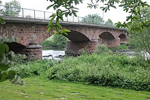
The first sandstone bridge over the Eder was built in 1885. Before there was only a wooden pier ( Specke ) in summer and a ferryman in winter.
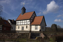
The listed small Protestant village church is originally a Romanesque building, which was changed in the late Gothic period and expanded to include a rectangular choir . Above the ship is a windowless half-timbered upper floor , which was probably formerly used as a fruit store . The bell that still exists today is said to come from the desert of Brechelsdorf , which is doubtful, however. The choir window was created in 1989 by the glass painter Erhardt Jakobus Klonk.
traffic
The Felsberg-Altenbrunslar stop is on the Kassel – Frankfurt railway line .
literature
- Literature about Altenbrunslar in the Hessian Bibliography
- Search for Altenbrunslar in the archive portal-D of the German Digital Library
Web links
- Altenbrunslar district. In: Internet presence of the city of Felsberg.
- Altenbrunslar. With local advisory board information and local history. Private website
- Altenbrunslar, Schwalm-Eder district. Historical local dictionary for Hessen. In: Landesgeschichtliches Informationssystem Hessen (LAGIS).
Individual evidence
- ↑ a b data and facts. In: website. City of Felsberg, accessed May 2019 .
- ^ City of Felsberg (ed.): City of Felsberg . District distribution. ( HTML [accessed April 28, 2010]). HTML ( Memento from December 9, 2012 in the web archive archive.today )
- ^ City of Felsberg (ed.): City of Felsberg . Population. ( HTML [accessed April 28, 2010]). HTML ( Memento from December 11, 2012 in the web archive archive.today )
- ↑ Altenbrunslar, Schwalm-Eder district. Historical local dictionary for Hessen. (As of June 15, 2016). In: Landesgeschichtliches Informationssystem Hessen (LAGIS).
- ↑ Henschel . ( HTML [accessed March 6, 2013]).
- ^ Altenbrunslar train station . ( HTML [accessed May 20, 2015]).
- ^ Municipal reform: mergers and integration of municipalities from January 20, 1971 . In: The Hessian Minister of the Interior (ed.): State Gazette for the State of Hesse. 1971 No. 6 , p. 248 , item 328, para. 46 ( online at the information system of the Hessian state parliament [PDF; 6.2 MB ]).
- ^ Federal Statistical Office (ed.): Historical municipality directory for the Federal Republic of Germany. Name, border and key number changes in municipalities, counties and administrative districts from May 27, 1970 to December 31, 1982 . W. Kohlhammer, Stuttgart / Mainz 1983, ISBN 3-17-003263-1 , p. 404-405 .
- ↑ Law on the reorganization of the districts Fritzlar-Homberg, Melsungen and Ziegenhain (GVBl. II 330-22) of September 28, 1973 . In: The Hessian Minister of the Interior (ed.): Law and Ordinance Gazette for the State of Hesse . 1973 No. 25 , p. 356 , § 18 ( online at the information system of the Hessian state parliament [PDF; 2,3 MB ]).
- ^ Federal Statistical Office (ed.): Historical municipality directory for the Federal Republic of Germany. Name, border and key number changes in municipalities, counties and administrative districts from May 27, 1970 to December 31, 1982 . W. Kohlhammer, Stuttgart / Mainz 1983, ISBN 3-17-003263-1 , p. 404-405 .
- ^ Georg Dehio: Handbook of German Art Monuments: Hessen . Deutscher Kunstverlag, Munich 1966, p. 10


