Eckerich (Fritzlar)
| Eckerich | ||
|---|---|---|
|
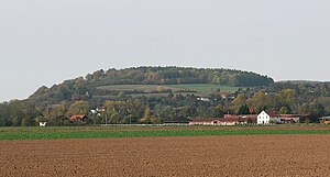
View from the Ederaue south of Fritzlar north-northwest towards the Eckerich |
||
| height | 266 m above sea level NHN | |
| location | between Geismar and Fritzlar ; Schwalm-Eder-Kreis , Hessen ( Germany ) | |
| Mountains | West Hessian mountainous region | |
| Coordinates | 51 ° 8 '3 " N , 9 ° 15' 26" E | |
|
|
||
| particularities | Eckerichswarte | |
|
Fritzlar - from the Topographia Hassiae by Matthäus Merian the Younger 1655; left behind the Eckerich with the Eckerichswarte |
||
The Eckerich is a 266 m above sea level. NHN high mountain, the southernmost elevation of the Elberberger heights , between Geismar and Fritzlar in the Hessian Schwalm-Eder district .
Together with the Büraberg ( 274.9 m ) facing south-west on the southern bank of the Eder , it forms the Porta Hassiaca , through which the river breaks from the Wildunger Senke into the Fritzlarer Ederflur and thus into the Wabern plain . The Eckerichswarte stands on the Eckerich , and there is a former limestone quarry on its western slope .
geography
location
The Eckerich is located directly between the Fritzlar district of Geismar in the northwest and west and the Fritzlar core city in the southeast and east. The mountain falls quite steeply in the west and south-west to the valley of the Eder about 100 m below and also in the north-west to the Fritzlar district of Geismar, while it only gradually flattens out in the east and south-east, towards Fritzlar. In the valley to the west below the Eckerich, the Elbe coming from the north flows towards its confluence with the Eder between Eckerich and Büraberg. Beyond the Elbe, the Biening ( 221.9 m ) rises to the west .
Natural allocation
The Eckerich belongs to the natural spatial main unit group West Hessisches Bergland (No. 34), in the main unit Ostwaldecker Randsenken (341) and in the subunit Naumburger Senken and Ridge (341.4) to the natural area Elberberger Heights (341.42) and lies at its southern end. To the west, the landscape falls in the same subunit into the natural area Elbergrund (341.41). To the south it descends into the Fritzlarer Ederflur (343.211), which belongs to the natural area of Wabern Plain (343.21) , and to the east into the natural area of Fritzlarer Börde (343.23), which in the main unit West Hessian Basin (343) belongs to the subunit Hessengau (343.2).
nature
Flora and fauna
The summit plateau of the Eckerich, around the Eckerichswarte, is forested. The adjacent orchards and regionally important limestone grasslands are designated as a landscape protection area (LSG). Since 1994 the range of faunistic and floristic species in this area has increased by 30%; including many species on the “Red List”. The cross gentian (gentiana cruciata) and the cross gentian ant blue (Phengaris rebeli) are particularly important .
Protected areas
The LSG Eckerich near Fritzlar ( CDDA no. 378436; designated in 1968; 39.71 hectares in size) is located on the Eckerich and especially on its southern slope , to which the LSG Auenverbund Eder (CDDA no. 378400; 1993; 45, 0585 km² ). The fauna-flora-habitat area Eckerich near Fritzlar is located on its north, west and south flanks (FFH no. 4821-305; 26.6 ha).
history
Eckerichswarte
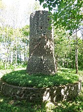
On the summit plateau of the Eckerich stands the Eckerichswarte in dense forest , a watch tower built around 1350, part of the medieval city fortifications of Fritzlar. The round tower made of natural stone with a wall thickness of 1.35 m is about 8 m high, 20.8 m in circumference and 4.5 (above) and 5.4 m (below) in diameter. The tower is surrounded by a deep ditch, a retaining wall around the inside with a diameter of almost 14 m and the remains of a ring wall surrounding the ditch . The entrance door is about 3.5 m high; there is no longer any staircase leading to it.
Quarry
On the steep western slope of the Eckerich, limestone was mined from the mighty deposits of the lower shell limestone (wave limestone) raised by volcanic basalt eruptions until the 1950s . It was transported with tipping lorries over a short field railway to a lime kiln on the south-western slope and processed there into quicklime , which is important in the construction industry . The former quarry is now used as a barbecue area.
Opportunities for viewing
From the slopes of the Eckerich, depending on the direction of view, there are excellent views: to the west into the Edertal in the direction of Bad Wildungen , to the south and east to the city of Fritzlar, to Homberg and to the Felsberger Heiligenberg ( 393.3 m ) with the ruins of the Heiligenburg and to the northeast and north on the basalt peaks of the Gudensberg threshold around Gudensberg .
Traffic and walking
North past the Eckerich, coming from the Fritzlar district of Züschen in the northwest, through the Elbe valley and through Geismar, state road 3214, which then continues eastward to federal highway 450 and ends shortly afterwards northeast of Fritzlar at the L 3150. The L 3383 also reaches north of the elevation, which comes mainly eastward from the Edertal district of Wellen , between Geismar in the west and Fritzlar in the east. The residential streets of Geismar extend to the western slope of the elevation; these also run on the west to south slopes. The Bonifatiusweg runs over the Eckerich, which also leads through Fritzlar and Borken in Hesse, and a few kilometers south of the Ederaue is the 326 km long Barbarossaweg , which leads from Korbach in Hesse and to Tilleda in Thuringia .
Individual evidence
- ↑ a b Water map service of the Hessian Ministry for the Environment, Climate Protection, Agriculture and Consumer Protection ( information )
- ↑ Martin Bürgener: Geographical Land Survey: The natural spatial units on sheet 111 Arolsen. Federal Institute for Regional Studies, Bad Godesberg 1963. → Online map (PDF; 4.1 MB)
- ↑ Fritzlar Environment and Nature Conservation Group ( Memento of the original from June 2, 2015 in the Internet Archive ) Info: The archive link was automatically inserted and has not yet been checked. Please check the original and archive link according to the instructions and then remove this notice. , on fritzlar.de
- ↑ FFH area Eckerich near Fritzlar ( Memento of the original from June 2, 2015 in the Internet Archive ) Info: The archive link has been inserted automatically and has not yet been checked. Please check the original and archive link according to the instructions and then remove this notice. , on natura2000-verordnung.hessen.de
- ↑ Map services of the Federal Agency for Nature Conservation ( information )
- ↑ Eckerichswarte , on warttuerme.de
Web links
- ... Signposts through the landscape protection area and future FFH area "Eckerich" ... (Flyer), on fritzlar.de (PDF; 574 kB)
literature
- Reallexikon der Germanischen Altertumskunde , 2nd edition, Vol. 10, de Gruyter, Berlin / New York, 1998, p. 89, ISBN 978-3-11-015102-2


