
Gudensberger sleeper

The Gudensberger Kuppenschwelle ( topographic map TK25 no. 4822) is a 29.72 km² natural subunit (number 343.24) west of the Eder and north of the Eder tributary Ems in northern Hesse . It is part of the Hessengau (natural area 343.2) and thus the West Hessian Basin (natural spatial main unit 343).
Geographical location

The domed sill encompasses the wider area surrounding the small town of Gudensberg in the Schwalm-Eder district and lies between the Fritzlarer Börde (343.23) in the south and the Kassel basin (343.3) in the north and northeast. Neighboring the Fritzlarer Ederflur (343.211) is in the southeast and the Langenberg (342.02) in the northwest . The Gudensberger Kuppenschwelle is often regarded as the northeastern part of the Fritzlarer Börde, as it differs from the Börde in the narrower sense only in the occurrence of a number of mostly wooded basalt knolls of volcanic origin.
It is drained by the Eder tributary Ems and several smaller Eder tributaries such as Sommerbach and Pilgerbach to the east and crossed by the federal motorway A 49 and the federal highway 254 in a generally north-south direction.
Basalt domes
- Bußbalg ( 253 m above sea level ), near Gudensberg
- Gudensberger Burgberg ( 305.8 m above sea level ), in Gudensberg
- Hahn ( 255.8 m above sea level ), near Holzhausen
- Hasenberg ( 304 m above sea level ), near Lohne
- Lamsberg ( 322 m above sea level ), near Gudensberg
- Corpse head ( 265 m above sea level ), at Gleichen
- Lotterberg ( 305 m above sea level ), near Deute
- Mader Stein ( 265 m above sea level ), near Maden
- Nacken ( 227.3 m above sea level ), near Gudensberg
- Nenkel ( 307.1 m above sea level ), near Gudensberg
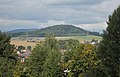
- Odenberg ( 381.2 m above sea level ), near Gudensberg
- Scharfenstein ( 304 m above sea level ), near Gudensberg
- Wartberg ( 306 m above sea level ), near Kirchberg
- Basalt domes of the Gudensberg domed sleeper
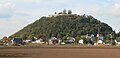
Gudensberg Castle Hill

Rooster

Lamsberg

Corpse head
Lotterberg

Mader Stein

Nenkel

Odenberg

Scharfenstein

Wartberg


History
The Gudensberger Kuppenschwelle and the Fritzlarer Börde were the center of the Chatti settlement area, from which the Franconian Hessengau emerged in Franconian times . The settlement history of the area with its fertile loess and black earth soils goes back at least to the Neolithic ; after the Wartberg near Kirchberg, their main find, the Wartberg culture from the time of 3500 BC. BC to 2800 BC And the stone chamber grave of Züschen is an impressive ground monument from this era.
Coordinates: 51 ° 10 ′ 12 ″ N , 9 ° 23 ′ 24 ″ E
Web links
literature
- Marion Gunreben: Black Earth Relics. A regional comparison of soils in the Magdeburg Börde, the Schöppenstedter Lößmulde, the Fritzlarer Börde, the Amöneburg Basin, the Wetterau and the Rheinhessen table and hill country. Dissertation, Philipps University of Marburg, Department of Geography, 1992
- C. Hauptenthal: About black earth in the Lower Hessian Depression. In Geol. Jb. Hessen , year 106, Wiesbaden, 1978, pp. 319-366.