Lohne (Fritzlar)
|
Rewards
City of Fritzlar
Coordinates: 51 ° 10 ′ 45 ″ N , 9 ° 16 ′ 0 ″ E
|
|
|---|---|
| Height : | 237 m above sea level NHN |
| Area : | 11.73 km² |
| Residents : | 700 approx. |
| Population density : | 60 inhabitants / km² |
| Incorporation : | December 31, 1971 |
| Postal code : | 34560 |
| Area code : | 05622 |
Lohne is a district of the cathedral city of Fritzlar in the north Hessian Schwalm-Eder district with approx. 730 inhabitants. Even today, Lohne is almost entirely agricultural. The three neighboring towns of Dorla , Werkel and Lohne are popularly known as "Hessenlandes Krone". The fertile, deep soils of the Fritzlarer Börde are among the most productive between the Eder and Ems in the Lower Hessian valley. There are nine clubs in the village.
history
In a register of the monk Rudolf from 850 about donations from the noble Ratolf to the Fulda monastery , Lohne is mentioned for the first time as "villa Loha". (Other sources, however, give the year 817.)
Around 1300, Lohne belonged to the Landgraviate of Hesse . In 1312, Landgrave Otto I pledged the villages of Lohne, Gleichen and Heimarshausen , which belonged to the "castrum" (office) of Gudensberg , to the Waldecker Count as compensation for military service ; the pledge was redeemed again in 1365. From 1403 the place belonged again to the Hessian office Gudensberg. In the Mainz-Hessian War of 1427 between the Archdiocese of Mainz and the Landgraviate of Hesse, Mainz troops under Gottfried von Leiningen plundered the place.
The lower jurisdiction was exercised until 1536 as a Hessian fiefdom by the noble family of the Lords of Elben ; after their extinction, the landgraves withdrew the fief and exercised the inferior and embarrassing jurisdiction themselves.
From the Thirty Years' War Lohne was not spared. In 1631 Tilly's troops sacked the village. In 1640, almost the entire village including the school burned down, only 11 houses were spared.
On December 31, 1971, the previously independent community of Lohne was incorporated into the city of Fritzlar.
politics
The current mayor is Margot Sauer. (As of October 2013)
church
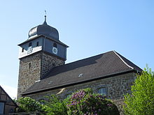
The medieval tower, which was used as a defensive tower in earlier times , has been preserved from the Romanesque church . The nave in its current form was built from 1793 to 1794. The church tower was given an onion-shaped tower dome in the 17th century. The tabernacle inside the church dates from before the Reformation .
Stone chamber grave and Hasenberg
The Züschen stone chamber grave , located between Züschen and Lohne, provides information about the thousands of years of settlement history in this region. It is one of the most important prehistoric soil monuments in Central Europe and dates from the 4th to 3rd millennium BC. The stone box is named after the neighboring town of Züschen, but is in the district of Lohne. It was named because the grave was discovered in the field of a miller from Züschen and the inspector and owner of the Züschen Garvensburg initiated the archaeological investigation.
About 700 m southwest of the village is the 304 m above sea level. NHN high Hasenberg , a wooded basalt knoll , on which there was a late Stone Age hill settlement of the Wartberg culture . There, in particular, arrowheads from the late Wartberg culture (3000-2700 BC) were found, which are now exhibited in the Fritzlar Regional Museum. The stone chamber grave probably served the settlement on the Hasenberg as a burial place for their deceased.
Web links
- Pay on the website of the city of Fritzlar
- "Lohne, Schwalm-Eder District". Historical local dictionary for Hessen. In: Landesgeschichtliches Informationssystem Hessen (LAGIS).
- Literature on wages in the Hessian Bibliography
Individual evidence
- ↑ a b "Lohne, Schwalm-Eder District". Historical local dictionary for Hessen. (As of November 11, 2014). In: Landesgeschichtliches Informationssystem Hessen (LAGIS).
- ↑ The location on the website of the city of Fritzlar , accessed in February 2016
- ^ Federal Statistical Office (ed.): Historical municipality directory for the Federal Republic of Germany. Name, border and key number changes for municipalities, counties and administrative districts from May 27, 1970 to December 31, 1982 . W. Kohlhammer GmbH, Stuttgart and Mainz 1983, ISBN 3-17-003263-1 , p. 392 .
- ↑ Map services of the Federal Agency for Nature Conservation ( information )
- ↑ http://museen-in-hessen.de/de/museen/regionalmuseum_fritzlar

