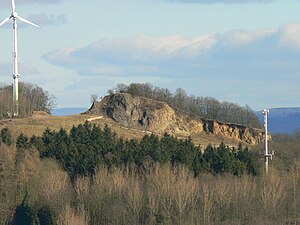
Lamsberg
| Lamsberg | ||
|---|---|---|
| height | 322 m above sea level NN | |
| location | Gudensberg , Schwalm-Eder-Kreis , Hesse , Germany | |
| Mountains | West Hessian mountainous region | |
| Coordinates | 51 ° 10 '41 " N , 9 ° 23' 29" E | |
|
|
||
| rock | basalt | |
The Lamsberg is a 322 m above sea level. NN high basalt knoll located in the north Hessian Schwalm-Eder district near Gudensberg in the West Hessian highlands .
Geographical location
The Lamsberg rises as part of the Gudensberg threshold in the West Hessian Depression east of the Gudensberg town center. A little east-south-east of the mostly forested mountain is the Ittersberg, and south-south-east is the Mader Heide .
East-southeast of the Lamsberg, in the depression of the Ittersberg, the Eder tributary Sommerbach rises , which is also fed by the Sonneborn north of the mountain . District road 7 runs from Gudensberg to Deute to the north, in a west-east direction . The Grifte – Gudensberg small railway , which the loading ramp of the former open-cast mine still bears witness to today , also ran past Lamsberg.
useful information
Finds from the Rössen culture (4500 to 4300 BC), an epoch of the Middle Neolithic , were discovered at Lamsberg . There used to be an open pit basalt mine on the mountain . Nowadays there is a wind turbine on the mountain and at the south foot there is a rifle house with a shooting range and a barbecue hut . From the mountain, the view of Gudensberg and the chat with the nearby Edertal can be enjoyed.
legend
According to legend, the devil wanted to smash the first church of Bonifatius in Fritzlar from Lamsberg or Mader Stein , which was built from the wood of the Donar oak , with a stone. This got stuck in his sleeve when he was thrown and fell on a field on the outskirts of Maden. The stone is called the Wotan stone .

