
Love Island (Edersee)
| Love island | ||
|---|---|---|
 |
||
| Waters | Edersee | |
| Geographical location | 51 ° 10 '35.7 " N , 9 ° 0' 8.8" E | |
|
||
| length | 190 m | |
| width | 54 m | |
| surface | 0.76 ha | |
| Highest elevation | 248 m | |
| Residents | uninhabited | |
| main place | Bring Castle (historical) | |
 |
||

The love island is a former castle hill in the Eder valley near Bringhausen in the north Hessian district of Waldeck-Frankenberg . The island, which was created from the construction of the Edertalsperre , which was built at Hemfurth-Edersee from 1908 to 1914 , is located in the Edersee and is the only continuous island in the largest reservoir of the Eder when it is fully flooded . There are remains of Bring Castle on it .
geography
location
The Love Island is located in the central part of the Edersee in the Kellerwald-Edersee Nature Park - in the northern vicinity of the Kellerwald-Edersee National Park . It is located in the Bringhauser Bay between the approximately 800 m west of the Edertal municipality of Bringhausen and the approximately 400 m east-northeast of the Scheid peninsula , which belongs to the Nieder-Werbe district of Waldeck . The island is about 300 m away from the original Eder river bed, which runs east-northeast .
The Love Island consists of a small and a large island and, even when the Edersee is fully blocked, rises up as the only islet - although only a few meters - out of the water of the reservoir . The islands are covered with bushes and trees (e.g. old oaks with roots running over the rock).
Natural allocation
The island of love belongs to the natural spatial main unit group West Hessisches Bergland (No. 34) and in the main unit Kellerwald (344) to the subunit Ederseetrog (344.4).
Castle Bring
On the partly steep and rocky, but only about 25 m above the valley floor towering Bringhauser Burgberg - today's love island - was formerly the small castle Bring , also called "Burg Bringhausen" or "Bringhauser Burg". It is unclear when it was built. The local noble lords of Bringhausen were first mentioned in a document in 1196, but the castle was probably built earlier. The builder is said to have been called "Brunink", and "Burg Brunink" became "Burg Bring" in the course of time.
A few remains of the wall remain from the castle, which essentially consist of a foundation wall. Around these remains there are legends not only of knights , but also of imaginative creatures, the elves , who are said to have guarded the gold of the Eder.
Altbringhausen
The village of Bringhausen or Altbringhausen extended west below Bring Castle until the Edertalsperre was built . When the water level in the Edersee is high enough, it is submerged. A bridge, built in 1897, led over the Eder, connecting the village with today's Scheid peninsula and thus also with the town of Waldeck north of the Eder. When the water level of the reservoir is low, there are few remains of the wall of the former village, and the pillars and abutments of the nearby former Eder bridge.
tourism
If the Edersee is completely blocked, the love island can be reached by boat , with an air mattress or by swimming. When the water level of the reservoir is low, a further smaller elevation appears to the west of the island in the Bringhäuser Bay, the tip of which is about 5 m below the water surface when the water level is full. If the water levels continue to decrease, both islands can then be reached on foot. This can be done in late summer and autumn in most years. Remnants of Altbringhausen are also visible. At very low water levels, such as in autumn 2003 and autumn 2008, the remains of the piers of the Bringhausen bridge and the old river bed of the Eder are visible again.
Picture gallery
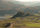
Love island with an adjacent elevation, in the foreground remains of stone from Altbringhausen (extremely low water, October 2008)

At low water (October 2008) 
Foundation walls as the last stone remains of Bring Castle


Individual evidence
- ↑ Martin Bürgener: Geographical Land Survey: The natural spatial units on sheet 111 Arolsen. Federal Institute for Regional Studies, Bad Godesberg 1963. → Online map (PDF; 4.1 MB)
literature
- Rudolf Knappe: Medieval castles in Hessen. 800 castles, castle ruins and fortifications. 3. Edition. Wartberg-Verlag, Gudensberg-Gleichen 2000, ISBN 3-86134-228-6 , p. 111.
Web links
- The castle ruins of Burg Bring in the Edersee ( memento from October 25, 2007 in the Internet Archive ) (photos of the island with castle ruins ), on archive.org