Ellenberg (Guxhagen)
|
Ellenberg
community Guxhagen
Coordinates: 51 ° 11 ′ 7 ″ N , 9 ° 28 ′ 1 ″ E
|
|
|---|---|
| Height : | 197 m above sea level NHN |
| Area : | 2.78 km² |
| Residents : | 687 (June 1, 2009) |
| Population density : | 247 inhabitants / km² |
| Incorporation : | 1st February 1971 |
| Postal code : | 34302 |
| Area code : | 05665 |
|
Ellenberg from above
|
|
Ellenberg is a district of the municipality of Guxhagen in the Schwalm-Eder district in northern Hesse .
The village is located south of the core town of Guxhagen, east of the Eder . The federal motorway 7 runs east of the village .
history
The village of Ellinberg was first mentioned in a document in 1357, when Landgrave Heinrich II of Hesse agreed with the abbot of the Breitenau monastery that in the Ellinberg court the lower jurisdiction should belong to the abbot and the higher jurisdiction to the landgrave.
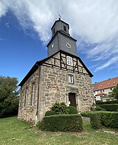
In 1585 the first church was built. The present day church dates from 1787.
The steles by Ellenberg found in 1907 and 1923/24 belong to the rare ornate archaeological rarities in the Fritzlar-Kassel area , along with the waves menhir .
Territorial reform
On February 1, 1971, the municipality of Ellenberg was incorporated into the municipality of Guxhagen as part of the regional reform in Hesse .
Population development
The village, which was once dominated by agriculture, experienced forced population growth in the last years of the war and the first few years after the war, due to the reception of bombed out people, refugees and displaced persons . After that, the population gradually declined again due to emigration, before it grew again relatively quickly from the 1960s onwards with the development of new building areas in the south of the village.
|
|
Personalities
- Gerhard Grau (* 1947), soccer player and coach
Individual evidence
- ↑ Ellenberg, Schwalm-Eder district. Historical local dictionary for Hessen. (As of July 29, 2015). In: Landesgeschichtliches Informationssystem Hessen (LAGIS).
- ^ Municipal reform: mergers and integration of municipalities from January 20, 1971 . In: The Hessian Minister of the Interior (ed.): State Gazette for the State of Hesse. 1971 No. 6 , p. 248 , item 328, para. 43 ( online at the information system of the Hessian State Parliament [PDF; 6.2 MB ]).
- ^ Federal Statistical Office (ed.): Historical municipality directory for the Federal Republic of Germany. Name, border and key number changes in municipalities, counties and administrative districts from May 27, 1970 to December 31, 1982 . W. Kohlhammer GmbH, Stuttgart and Mainz 1983, ISBN 3-17-003263-1 , p. 404 .
Web links
- Districts and history on the website of the municipality of Guxhagen.
- Ellenberg, Schwalm-Eder district. Historical local dictionary for Hessen. In: Landesgeschichtliches Informationssystem Hessen (LAGIS).
- Literature about Ellenberg in the Hessian Bibliography


